TECTONICS BLOG
Rev.
2025-03-02
Gregory Charles Herman,
PhD
Flemington, New Jersey, USA
Structural and geophysical aspects of some
known and suspected astroblemes
of the Great Lakes region, North America
A geology report with maps, cross sections, field photographs and
structural records from the Sudbury, Slate Island, and Wanapitei astroblemes in Ontario Canada
leading to a tectonic interpretation of the Great Lakes region invoking impact tectogenesis,
including a suspected large-bolide impact event in the Ohio River basin of
early
Grenville age.
Click on a picture for more detail.


Figure 1. Google Earth (GE) displays of Ontario known and suspected
multi-ring astroblemes using 4 geospatial themes including (B) the
bedrock geology of Canada and the USA, (C) Global magnetics, (D) Global
Bouguer gravity anomalies and (E) the NASA ETOPO1 global physiography.
The locations of the known Sudbury, Slate Island, and Wanapitei
craters and the suspected Lake Nipigon strewn field
circled at varying radii for mapping far-field strain effects. The down-range
headings of each impact are mapped using the thick yellow lines. Note
the location of the Lake Nipigon igneous suite where the leading crater
of a suspected impact strewn field is located.

Figure 2. Time line and stratigraphic column summarizing the relative ages of
the Ontario astroblemes in relation to the bedrock geology and some other large impacts and
igneous provinces. Crater sizes are scaled at 1 in. = 300 km.
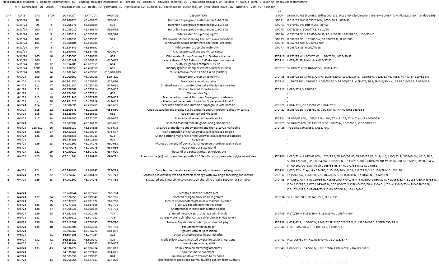
Figure 3. A summary of outcrop locations, photographs, and structural
readings taken during the excursion.


Figure 4. Nineteen photographic contact sheets for the set of Ontario
photos. Click on an image to see the file names. Access a photo by
typing in a file name using the following filename prefix: www.impacttectonics.org/2024/Ontario/.
For example:
www.impacttectonics.org/2024/Ontario/sulfidelacing.jpg
Table 1. Location, size, and age parameters for the known and suspected impact craters
addressed in this work.


Figure 5. The Sudbury and Wanapitei Lake astroblemes in GE using three
spatial themes including the (A) bedrock geology (ref), (B) global
magnetics (ref) and (C) a Space Shuttle Radar Tomography (SRTM) digital
terrain model.

Figure 6. SRTM image of the Sudbury and Wanapitei Lake astroblemes.
Interpreted own-range headings traced with yellow lines. Field stops and
roads taken highlighted along with the axial traces of anticlines (red
polylines) and syncline (blue polylines) .

Figure 7. GE bedrock geology map of the Sudbury basin. The roads
traveled, field stops, bedrock units and faults, copper mines, and mafic
dikes associated with the basal, mafic melt layer and superjacent
granophyre.


Figure 8. GE maps using a 100-km scale to summarize the geological
expression of the Slate Islands astrobleme. A. Features mapped on a
standard GE satellite image. B. Bedrock geology. The central peak of
Slate Islands lies close to the Terrace Bay shoreline along the head of
Lake Superior. The roads traveled, field stops, mapped bedrock faults,
copper mines, and seismic-reflection surveys in Lake Superior are
labeled. Concentric rings around Slate Islands and the suspected impact
crater at Lake Nipigon to the North are labeled using radii noted in
kilometers (km). Interpreted down-range heads are mapped for each
impact crater.
Please note that the Lake Nipigon one appears to be one of many in a
strewn field extending southward (fig. 1).

Figure 9. GE base imagery (left) and a registered SRTM image covering
the Slate Islands impact area along the north shore Of Lake Superior.
Down-range headings for the Slate Island's and suspected Lake Nipigon
impact craters are accompanied by line tracings of magnetic anomies and
seismic-reflection lines in the Lake Superior. White lines trace
interpreted
faults intersecting ground surface and the circular histogram summarizes
their strike orientations using 10o bins.

Figure 10. Dave Buthman points to one of the many faults cutting
rocks along the shoreline of Terrace Bay. We collected a combined set of
28 fault readings along a shoreline traverse. A dominant fault set
strikes sub parallel to the interpreted down0range heading (SW) and dip
away from the Slate Islands central uplift. The assortment of faults
having variable slip directions cutting the Mesoproterozoic basalt was
highly varied and complex. Fault orientations and dip azimuths
are summarized with the lower-hemisphere equal-angle stereographic
projection (above) and a circular histogram (below, using 10o
bins). The rocks have been multiply deformed with presumed Paleozoic, brittle-ductile faults offsetting earlier,
copper-mineralized veins with autoclastic breccia of
probable Keweenewan age (lower right).

Figure 11. A SketchUp Pro model of the Slate Islands impact crater was
made using the GLIMPCE seismic-reflection line A-A'. The line runs due
south from the crater and is mirrored on the other half to complete the
structural model. The assumption that the structure is symmetric as
portrayed is likely improbable but nevertheless is built to see if the
structures imaged beneath Lake Superior can be extended onto land.

Figure 12.
A suspected large-meteorite strewn field may be headed up by a crater
lying beneath the Lake Nipigon basin in Ontario. A set of aligned
geophysical anomalies stretch from lake Nipigon to the south end
of Lake Michigan. This event may have stemmed from a fragmented, larger
body or entered the atmosphere as a clustered set of projectiles. It's
alignment and association with Keweenewan age igneous activity suggests
that the enigmatic mid-continental rift may have originated from impact
tectogenesis

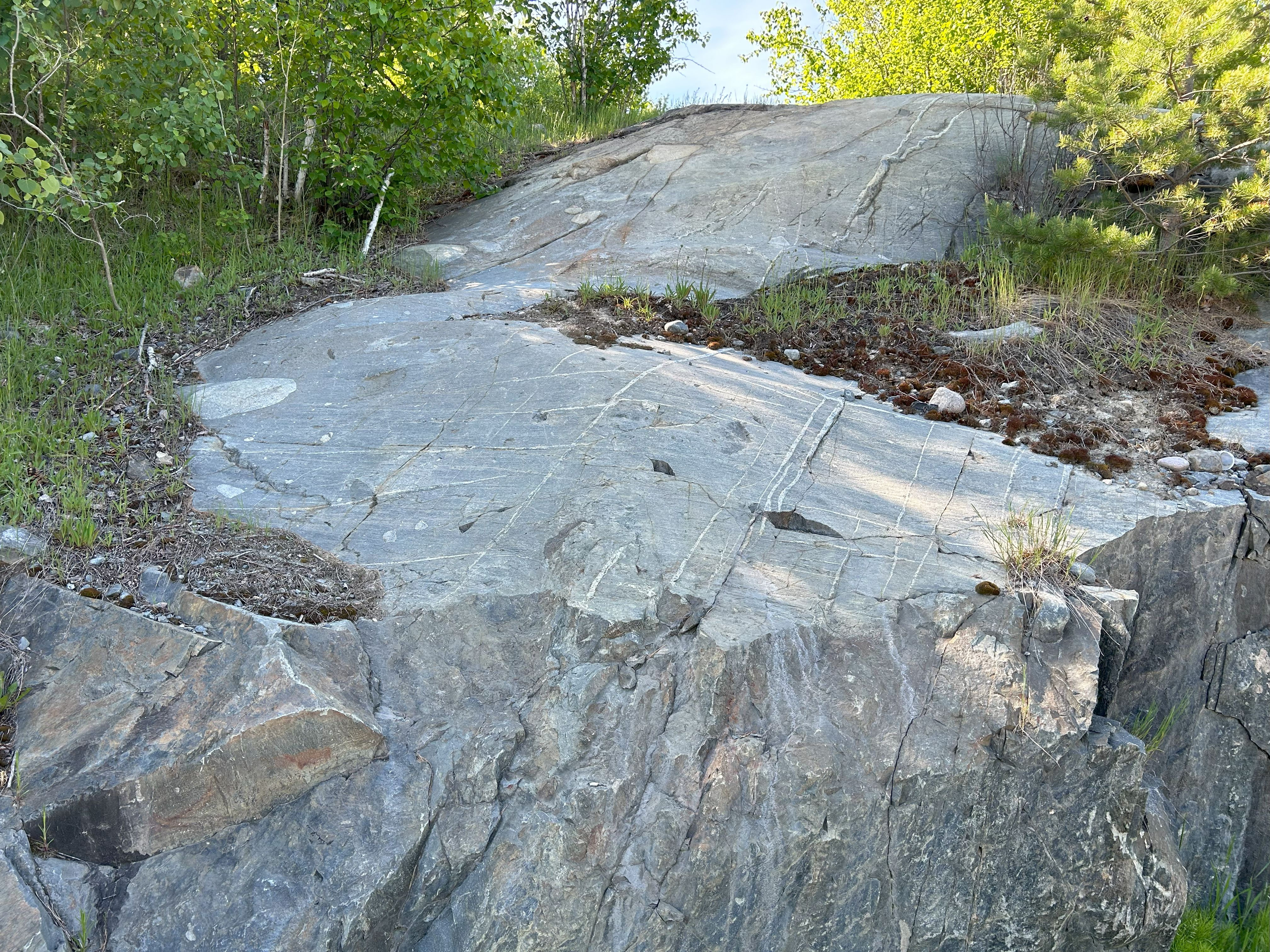
Figure 13. STOP 30 folds part of the upturned rim of the transient crater at 28 km (~17 mi.) distance from the
Slate Islands central
uplift. The outcrop holds sub vertical
layering including sills of Keweenewan age that are sheared with a sense
of western displacement.

Figure 14. Geological map centered on the Great Lakes
region of North America summarizing the distribution
and form of high-intensity magnetic and gravity anomalies thought to
reflect mid-continental rifting. Cross sections A and B included below
in figure 15.

Figure 15. Interpretive cross sections constructed across the southernmost part of the Canadian
shield (top) and the mid-continental rift system (bottom),

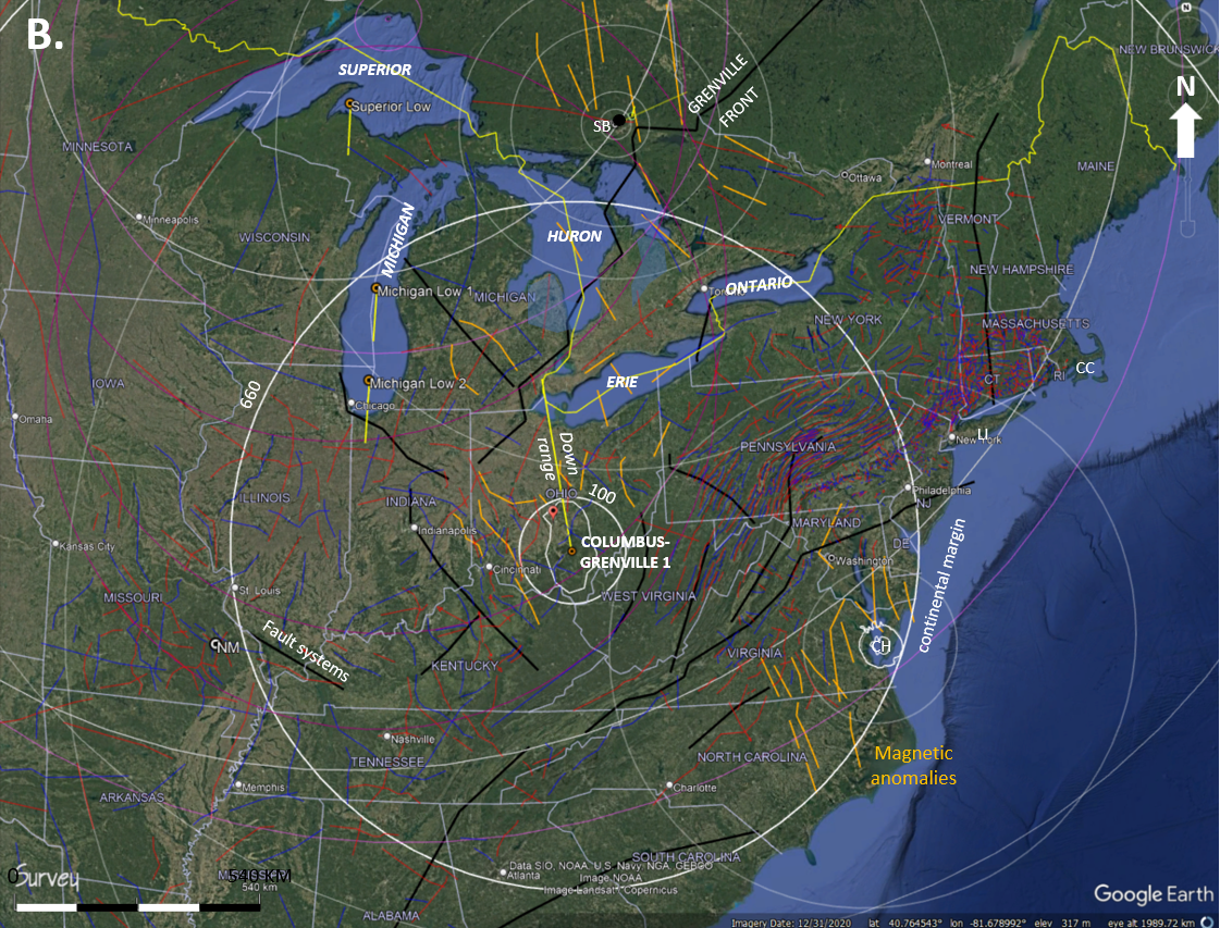


Figure 16. A series of maps centered on the suspected Columbus-Grenville
1 astrobleme.

Figure 17. Structural framework of the suspected Columbus-Grenville 1
astrobleme.

Figure 18. The high-intensity band of the EMAG2.0 vers. 3.0 Earth
magnetics theme was extracted and augmented with labeled tectonic
elements, large impact craters, and cross section trace A-A' (fig. 15). |
Data and methods *
Sudbury and Wanapitei Lake astroblemes *
The Slate Islands Astrobleme and suspected Lake Nipigon - Superior - Michigan strewn
field * The suspected Columbus-Grenville 1 astrobleme *
Summary * References *
Google
Earth KMZ file (4.9 MB)
Introduction
The energy absorbed by Earth from km-scale bolide
(asteroid or comet) impacts is tremendous. If just 10% of the total available
energy from the flight of a 1 km diameter bolide is absorbed upon impact, then
the sudden energy flux instantaneously exceeds the total amount of energy
estimated to be expended by plate tectonic over the course of a years time
(Swedan, 2013; Herman, 2022). In other words, km-scale bolide impacts occurring
at hypervelocity speeds immediately perturb Earthly tectonics. Most of the geological community
are unaware of this probability and the geological consequences. Most modern tectonic
studies still attempt to explain
plate-tectonic fluxes by invoking uniformitarian agents rather than the
obvious, catastrophic ones that periodically come to bear on global systems. A good
example of this in seen in a recent Nature article that correlates the
sudden, accelerated drift northward of the Indian tectonic plate 66 Ma ago to
sediment loading in a subduction zone but ignores the probability of
plate acceleration being
catalyzed by the grounded energy of the Era-ending Chicxulub impact (66 Ma) in the Gulf of Mexico (Zhou
and others, 2024). The Indian tectonic plate used to lie near the geographic
antipode of this event near the middle of the Indian Ocean and the introduction
of impact energy helps explain accelerated drift beginning at that
time. But in order to prove that impact tectogenesis is an integral part of
Earthly plate tectonics, it is necessary to find the geological proof everywhere
stemming from the periodic, catastrophic impacts that suddenly form great basins
and mountain ranges from rapid tectonic processes occurring at many hundreds to
thousands of kilometers beyond the actual impact
crater. Therefore, geological inquiry is needed beyond the impact crater where
the 'near-field' geological strains occur, and an accounting of the
impact-tectonic far-field (ITFF)
strains will result in the communion of the
catastrophic ones with the more uniform, orogenic ones and a clearer picture of
Earthly tectonics.
Initial recognition of far-field tectonic effects
stemming from the
Chicxulub impact on the North American plate occurred in the early
2000's after integrating ground-fixed global position systems data into a
neotectonic study of the central Appalachian region (Herman, 2006). That
impact event currently registers as the second largest known crater on Earth
(Earth impact database, 2024), brought the Mesozoic Era to a close, setup a new geodynamic
regime for
the world's tectonic plates, and likely sent India speeding off in the
direction of Asia proper. Upon recognizing far-field strains stemming
from the
Chicxulub event, I then suspected that many field structures that I had mapped
and reported on
in the Pennsylvania and New Jersey region were imparted directly down range by the
oblique Chesapeake impact (35.5 Ma) within the impacted geological foreland of
the Central Appalachian mountains (Herman, 2016; Mathur, 2016).
More recently in 2021, David Buthman contacted me after visiting
impacttectonics.org to share his similar views on impact tectogenesis that he
has realized from decades of hydrocarbon exploration and his recognition of far-field structural
effects around large impact craters that come to bear on petroleum entrapment
and commodity production (Buthman, 2022). After vetting one another
virtually over a year's time, and with continued interaction, we arranged to meet
to explore the Nevada desert in 2023 to see the grounded strains of the elusive
Alamo impact crater
who's near-field effects have been confirmed despite having a firm solution to
where the crater lies! This initial effort of studying large impact
structures together in the field was an attempt to better understand their
nature, reach, and significance. In retrospect, launching a combined effort starting
with the Alamo impact was somewhat frustrating but exhilarating at the same time
as we failed to find the crater but touched upon some amazing geology. The
frustration stemmed from realizing that the crater
central peak probably lies within military grounds with restricted access, so we
had to
focus solely on ITFF strains occurring just beyond the transient crater, of which there were many. Exhilaration
came
from gaining a new perspective over a week's time on the regional disruption
within a central Nevada astrobleme.
Our second, collaborative field venture was formulated
soon afterwards when we took aim at the Sudbury and Slate Island astroblemes of
Ontario (fig. 1). The Sudbury lies at the northern head of the Georgian Bay to
the east of Lake Huron and Slate Islands lies at the northern head of Lake
Superior (fig. 1). Sudbury is the third largest and fifth oldest (~1085 Ma)
known impact crater on Earth with an estimated transient crater of 139 km
diameter and radiometric ages of about 1850 million years (Ma; Earth impact
database, 2024). The Slate Islands crater is ranked 27th in size having an
estimated transient crater of 30 km diameter and is the 50th oldest known crater
with radiometric ages constraining a 436-450 Ma age range (upper Ordovician to lower Silurian). The Sudbury basin has been mapped in detail because of
its high-grade nickel-copper ore bodies including platinum, silver, tin and gold
that stoked Sudbury-area mining beginning in the late 19th century. The Slate
Islands structure is comparatively less defined beyond the central uplift that
forms the set of islands for which its named. It too has spatial association
with iron, copper and gold mines in the region. We planned a trip for May
31 to June 7 and met in Toronto with the goals of exploring both structures over
the course of a long week. We met on the morning of May 31 near the Toronto airport
and immediately drove
North to Sudbury before hitting outcrops starting about noon. Following is an
illustrated account of the preparation, field excursion, and findings leading to
some unexpected conclusions and hypotheses about the physical nature of the
Great Lakes basin.
Trip preparations included virtually mapping the bedrock geology
with the available regional geology and
geophysics themes using Google Earth (GE) Pro and the QGIS
Geographic Information system software. Three regional geology themes include
polygon shape files covering the USA and Canada (fig. 1; Schruben and others, 1974; Wheeler
and other, 1997), and a detailed polygon shape file supplied by the Ontario
Geological Survey (2011) . A regional stratigraphic column
is compiled in figure 2 that places
the bedrock geology units into a temporal perspective with respect to the large impacts
mapped below. It includes some other large, significant impacts and notable
geological events. Figure 3 summarizes the data and photographs that I collected
over the course of our 8-day expedition. Altogether we drove about 1600 miles
(fig. 1) and I logged 44 field stops with notes including 149 structural readings (fig. 3).
The complete set of photographs and field data collected in those eight days are
listed in figure 3. Photographic details can be accessed by following the
directions included in the figure 4 caption, or by downloading the
associated Google Earth
KMZ project file that
includes field stop place marks that are dynamically linked to the photographs at each
outcrop. The GE KMZ file includes geospatial elements for three known and two
suspected large impact events whose parameters are compiled in table 1. The GE
file is provided as an
otherwise undocumented project file lacking detailed explanations of features
that are organized by appropriately named object folders holding the various
geospatial themes and elements. Only the SRTM imagery for the Sudbury and Slate
Islands astroblemes are included as image files in order to reduce the size of
the shared file. The regional geology themes are also excluded for the same reason,
but are available upon email request.
Sets of global and national geospatial data themes were assembled and used to
examine the geophysical expression of each astrobleme that served as a basis for
mapping surface traces of
crustal faults and folds axes around each structure (figs. 5 to 10). The global geophysical themes include GE's surface
imagery, the United States of America (USA) National Aeronautics and Space
Administration (NASA)
ETOPO multi-color surface physiography (Amante and others, 2008), satellite-derived Bouguer gravity (Sandwell and other, 2014) and
two versions of the EMAG2 magnetics theme (Maus and other, 2014; Meyers and
others 2017). Digital
terrain models used in the study are from the February 2000 NASA Space Shuttle Radar Tomography
(SRTM; www.earthdata.nasa.gov/data). SRTM data are gathered using using
dual radar antennas and processed using interferometry to extract ground
heights. The distributed products are 30-meter resolution surface-elevator
models and associated imagery covering over 80 percent of Earth's land lying between latitudes 60 degrees north
and 56 degrees south. Monochrome images
were downloaded as sets of adjacent tiles that when assembled using QGIS with
geographic coordinates to build a uniformly
gray-shaded theme of the detailed physiography (figs. 5, 6, and 9). The SRTM visual terrain variations help constrain the
location and nature of geological faulting in an area. Historical GE aerial
imagery is also available for many years and provides a comparison of seasonal variations
in the photo-compiled ground cover. Together these geospatial themes are used to
virtually map geological faults that are seen intersecting Earth's surface. GE's historical
imagery is in particular very useful in providing a basis for mapping geological
gold axes where the geological strata are bent and folded.
Structural features
were manually digitized on the virtual ground surface using polylines in GE and
the QGIS geographic information system. Polylines are formed by connecting
straight line segments end to end at vertices. Polyline traces of fault traces
were manually digitized along apparent structural discontinuities from visual
scrutiny of
the stock GE imagery augmented by the various geophysical themes including the SRTM imagery (figs. 4D, 5 and 9). Anticlines are
mapped using red polylines and syncline blue, respectively. Surface-water drainage systems typically follow
crustal faults where they intersect the land surface because stream and rivers
are focused along and cut down through highly fractured bedrock associated with faulting. Surface water bodies also commonly pond in the
keel of crustal synclines where the rock is tilted inward toward a center line
along their axial traces. Synclines are therefore easier to
map using satellite and space-born imaging than anticlines where the Earth
is arched upward and comparatively dry at the surface along the map trace of the axial surface
(fold axis).
Once the faults were mapped, a QGIS plugin by Håvard Tveite (ver. 3.1.1) was
used to generate circular histograms of fault strikes selected within
the boundary of each SRTM image. The circular histogram use 10o
bins to summarize the most frequently occurring fault strikes in each region. Because
their are commonly overlapping astroblemes in a region, the comprehensive plot of fault strikes
reflects the finite strains accumulated from many tectonic events
formed in response to the different impact and orogenic episodes.
Tectonic inheritance and structural overprinting of one astrobleme by
another is a common phenomenon in the Great Lakes region that requires discriminating between structures
generated by each event in order to understand each incremental strain field. This is a highly subjective, laborious pursuit requiring complimentary field
and laboratory work to
ground truth virtual interpretations. But in some instances, relatively young
and topographically pronounced faults and/or fault systems are clearly seen overprinting, cutting across, and interfering
with older faults and fault systems. A good example of this occurs in the Slate
Islands astrobleme, where a comparatively young fault system striking parallel
to the interpreted bolide heading cuts across and offsets all earlier structures
in the area (figs. 8 and 9). These fault system are mapped over 60 km away from the Slate Islands
central impact peak and lie between 30 to 50 km away from the central peak on shore within the Canadian shield.
These bracketing fault systems reflect axial splitting of the crust from
impact-generated shock strains generated by an oblique indenter that are further
elaborated on below. Structural inheritance occurs here from Slate Islands
structures overprinting earlier 'rift' structures that may instead stem from a
suspected meteorite strewn field headed up by the Lake Nipigon structure (figs. 9
and 12). Such tectonic inheritance profoundly
complicates the geology of an area by former structures directing the course of
subsequent structures imparted during younger tectonic episodes. This is also
seen with respect to the Sudbury astrobleme (1.85 Ga) influencing
the fault geometry of the ensuing Grenville tectonic cycle beginning around (~1.4 Ga).
Aspects of the overlapping strain fields are mapped and below and as a composite, finite-strain field covering much of the
Great Lakes where there are probably other large impacts that still remain to be
identified and confirmed.
The first three field days were spent visiting outcrops
around the Sudbury and Wanapitei Lake craters that I had never seen before including shatter cones and
a variety of thick-bedded impact-generated breccia that struck me with a sense
of enormity and widespread disruption that was awe inspiring. During that time
we logged 19 field stops along traverses across the Sudbury basin's western and
eastern ends, the latter of which touched upon the smaller Wanapitei impact
crater (figs. 1, 4, 5, and 6). A local
billboard there welcomes visitors to the
Wahnapitae First Nation. But the name Wanapitei is used
here in conformance with that listed in the EID and in GE Pro.
Dave had prepared the first day's itinerary based on
some field guidebooks covering the area including those by Lightfoot and others (1997) and Rousell and Card (2009).
The first outcrop that we visited within the Sudbury City limits has pervasive,
nested sets of shatter cones (photos
0585,
586,
587,
588,
589) within Paleoproterozoic metasedimentary bedrock of
the Huronian Supergroup. These bedrock units are elsewhere extensively brecciated and
cemented with impact-generated melt (photos
0592,
593,
594,
595).
We also touched upon the the impact-generated
melt sheet (figs. 4A, 4B, and 6) and
fall-back breccia (photos
0606, 0608), both of which also carry post-impact,
hydrothermal mineral veins and tectonic fractures. Nearby outcrops of the subjacent impact-injection breccia (photos
0610, 0611,
0612, 0613) preceded stops in the superjacent basin fill of sedimentary
origin (photos 0597,
0598, 0599,
0600) that were once deeply buried and then tectonically compressed and
compacted,
uplifted and exhumed to reveal the astrobleme core structure today. There are
probably similar, fractionated melt sheets associated with other large craters
around the world, but they remain deeply buried beneath thick sediment blankets
until regional tectonism may one day reveal their roots too.
The elliptical geometry of the Sudbury basin partly
reflects post-impact tectonic overprinting of the basin from compression
directed subnormal to the current basin axis during the Grenville Orogenic cycle
(fig. 2). The Grenville post dates the the Sudbury impact by about 700 Ma with
the deformation front skirting the southern side of the Sudbury basin (fig. 4C). The line drawn along the Grenville front corresponds to a pronounced, linear
magnetic low where crustal rocks have been structurally compounded and thickened
from tectonic accretion along the southern margin of the Canadian
shield (fig. 1C). The
Grenville front angles acutely away from the Sudbury basin to the south and
merges with the straight-line projection of the down-range heading line to the
northeast. The front appears structurally complicated immediately south of the
Sudbury basin from crustal compounding of previously impact-faulted bedrock
lying within the southern, lateral blast sector of the Sudbury astrobleme where
large crustal faults flare outward from the basin into adjacent bedrock to the
north and south along with probable dike emplacement signaled by high-intensify
magnetic anomalies (fig. 4). The southern blast sector of the Sudbury astrobleme was
therefore first subject to mixed-mode
faulting striking about normal to the basin axis resulting from the low-angle
impact of less than 30o obliquity based on the elliptical crater, and
impact experimentation (Gault,
D.E., and Wedekind, 1978). Crustal compounding of
heterogeneous bedrock with shock-induced faults striking about normal to the
subsequent shortening direction therefore results in a complex block-fault slip history with complicated geological
history and
geophysical expressions. An example of complex structure exhibiting these traits
occurs on Route 400
that was our last stop of the trip during the day 7 drive back to Toronto (photos
0627, 0628,
0629). It occurs about 150 km
SSE from the Sudbury basin and exemplifies the structural complexity of multiply
deformed Mesoproterozoic basement subject to at least two tectonic episodes. It
is reasonable to assume that one was Sudbury and another Grenville; those
tectonic events of which we have radiogenic ages for. STOP 21 on day 4
located about 170 km to the west of Sudbury also held probable ITFF structures
including massive stock-work veining with secondary mineralization including Bornite
(photos 0649,
0650,
0651, 0652,
0653, 0654,
0655). The impact-generated crustal faults and dikes swarming
laterally outward and away from the Sudbury basin (figs. 4, 5 and 6) extend for over 500 km and link
with highly complex crustal structures elsewhere in the shield like the
Kapaskasing fault zone and prior dike swarms. ITFF strains stemming from the Sudbury impact event
therefore cover a map diameter exceeding 1000 km.
The
Sudbury impact is thought to have succeeded the Penokean orogeny, a proposed
orogenic event reported in the Lake Superior region where a
volcanogenic arc was docked onto the Archean Superior craton just prior to
impact and during a time when the region experienced major contraction (fig. 2;
Schulz and Cannon, 2007).
But sedimentation in the subsiding foreland began at 1850 Ma in the south and
slightly later to the north correspond in age with the Sudbury impact,
so the need for a Penokean orogeny is unnecessary if the recognized tectonism resulted
from the Sudbury impact. Traditionally, the Grenville Orogeny is also
thought to stem from arc collision accompanying tectonic plate drift, plate subduction and suturing of accreted Mesoproterozoic terrane
onto the Superior craton (Stein and others, 2017). But as exemplified below, there are
also alternative explanations for the
Grenville tectonic cycle that hypothetically arise from impact tectogenesis. The Grenville front in this region was influenced by crustal heterogeneity
imparted by the Sudbury impact and then structurally overprinted by the
Wanapitei Lake crater. The manner in which structural interference is
manifest is portrayed in figures 5 to 7, but
more work is needed to better understand how the Eocene-aged Lake Wanapitei impact
structurally modified the Sudbury basin and the bedrock shield down range where the SRTM data
show areas of anomalous crustal reflectance within 100-km distance of the crater
(fig. 5D).
The serendipitous alignment of the Wanapitei Lake impact
crater immediately downrange of the Sudbury one has created overlapping strain
fields that complicates the area's geology (figs. 4 and 5). The Wanapitei
Lake astrobleme is younger (table 1) and one-order-of-magnitude smaller than
Sudbury with a transient crater mapped at ~20 km diameter (table 1). It too holds ample shock
evidence including localized suevites, shatter cones, and breccia (Dressler,
1982). We only stopped at a few places on the western side of the Lake where the
two transient craters overlap. A recent road excavation exposed some shatter
cones within a finely crystalline diorite (photos
0632,
0633, 0634,
0635) that may have resulted from the Wanapitei
event, but assignment to a specific event is hypothetical as it falls within the
area covered by both transient craters. Another stop in the overlap area held
younger quartz veins overprinting an offsetting older ones within a low-grade
metamorphic, subarkosic wasckestone near the base of the Huronian Supergroup (Mississagi Fm. photos
0637, 0638). The complex
vein interplay demonstrates the need for detailed
field mapping in order to understand how inherited
structure here are systematically modified by younger episodes of impact
tectogenesis. Over the course of those three days, the tapestry of structures
that we saw in the Sudbury astrobleme are of such variety
and magnitude that it left us somewhat stunned, but more familiar with the
geological havoc arising within these energized structures.
On day 4 we arose earlier, grabbed breakfast and hit the
road west and north to Wawa, ON, bringing us into the realm of the Slate
Island astrobleme. Day 4 was thus spent driving over half of the ~700 km between Sudbury
and Terrace Bay on the northern tip of Lake Superior (fig. 7). We planned to
stop at a motel in Wawa by mid afternoon so that we could head out to find
outcrops of the Firesand carbonatite located nearby (close to STOP 23 on figure
7). This intrusion is of Keweenewan age (1090 +
10 Ma; Symons, 1989) and forms a low hill within a forested area accessible by
an unpaved and rutted dirt trail. Prior to this we had been conducting urban and
suburban geology but this was rural; big-animal country. The trial was dry
so we drove in as far as we could in our sedan, got netted and deated up to
counter the black flies and mosquitos, but by the time we hiked to the hill, it
was dusk and an imposing swamp situated between the trail and hill thwarted our
attempt. Sometimes plans just don't work out, so we headed back to the motel,
nevertheless excited for what lay ahead.
Upon descending from the shield uplands into Terrace Bay,
the sky was vivid blue with puffy white clouds being wind swept northward. It
was a brilliant vista with the dark green evergreen forests rolling unbroken
beneath the drifting clouds that altogether struck me with a sense of majesty. We
didn't know at the time that this would be the last fair weather that we would
see over the next few days as a fog bank set in shortly afterwards that
led to periods of intermittent showers that hampered our field work somewhat
over the next three days. Field work during days 5 through 8 left
us damp but exhilarated by providing evidence of the transient crater reaching
at least 120 km diameter based on the distributed pattern of crustal faulting
and shatter structures. As mentioned above, the Slate Islands transient crater
is officially listed at 30 km, but we found evidence making it at least four
times larger than previously thought. This impact likely helped sculpt the Lake
Superior physiography, overprints and partly remobilized older copper deposits
of likely early Keweenewan age (~ 1100 Ma; fig. 2) and emplaced new polymetals in
the area; especially down range to the west. We saw proof of this at many places
around Terrace Bay with some road cuts providing amazing glimpses into
the structural and hydrothermal processes operating near the edge of the transient crater.
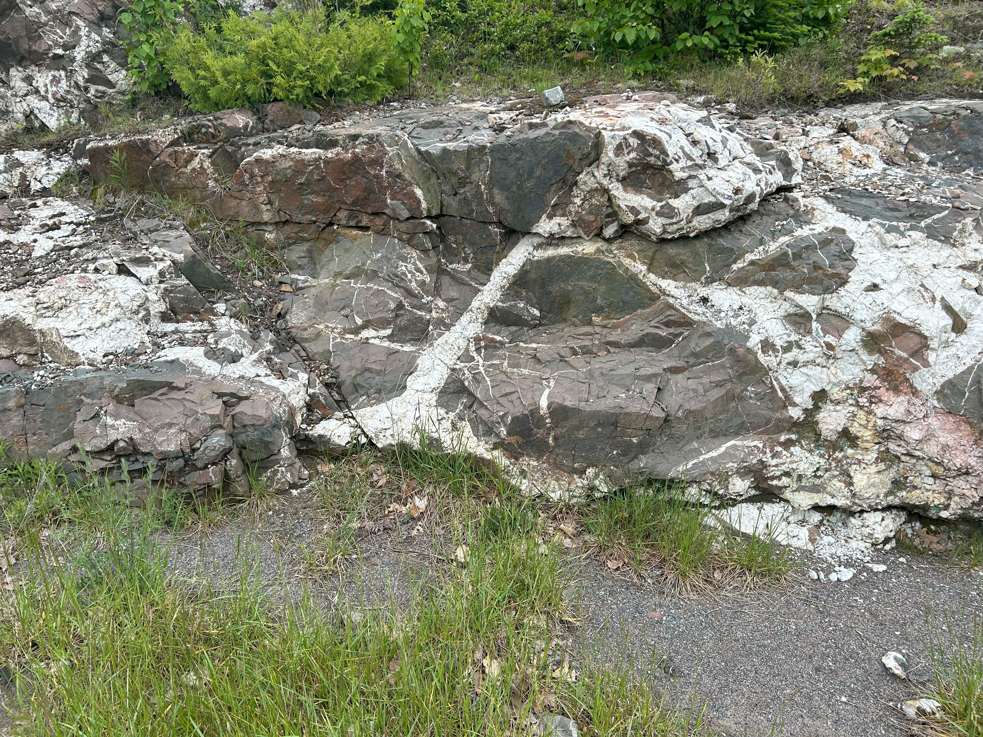
For example, a series of three road cuts (STOPS 30-32) just to the west of
Terrace Bay on Route 17 hold a spectacular assemblage of impact-generated
structures including very thick (>3), sulfide-laced pseudotachylyte showing dynamic metal emplacement
accompanying shock-generated frictional melting (STOP 32 photos annotated below). These road cuts are about
28 km distance from the
central uplift and testify to the manner in which crustal rocks are melted,
plasticized, and broken within the transient crater from the impact's grounded energy.
Structural details and photographs collected at these three stops are outlined
and summarized below. Please follow the instructions provided in the caption of
figure 4 to view the photographic details.
STOP 30 Archean granodiorite cut by younger granite
and even younger (~1.10 Ga?) sills cut by pseudotachylyte w/ sulfides (photos 0691-0721).
This outcrop includes Archean intermediate rocks that are intruded with younger
granite, both of which are cut by basic sills and dikes of presumed Keweenewan
age (~110 Ma; fig. 2). The rocks are turned up on end with layering dipping near
vertical (fig. 12). Relatively young, low-angle shear
planes and faults with slip lineation cut all older structures and show western-directed reverse shearing, compounding and transport.
STOP 31 Complex quartz-calcite vein in sheared,
sulfide-infused diorite. The lesser of the three series of outcrops
nevertheless holds some intriguing features, among which is a
thick calcite vein holding
euhedral, milky quartz crystals in the medial
area. Sulfide-infused, quartz-mineralized shear planes are also seen here that were a
prelude to what we were about to see in splendor in the next set of outcrops likely
corresponding to the rim of the transient crater.
STOP 32 Tectonic mélange with low-angle
thrusting, massive pseudotachylyte and polymetal infusion. I was
motivated to see the
Ontario astroblemes in order to experience the suite of impact-generated structures
including pseudotachylyte
that I had only read about but hadn't never see before. We didn't recognize any
in Nevada, and we saw some at Sudbury, but we were both somewhat startled to see it
developed so profoundly here and holding evidence of polymetal infusion
accompanying the sudden, frictional melting of the shield basement down range at
28 km distance from the central peak. This was the next to last outcrop sequence
seen on day 6. It was so impressive that we decided to revisit in as part of our
day 7 itinerary which was first aimed at seeing ITFF structures further west before
backtracking and heading north to explore structures at around the 28 km radius
there. Below is an annotated list of features photographed at STOP 32 by IMG
number.
1. Hydrothermal blistering and polymetal infusion
0729, 0732,
0734, 0735,
0736, 0737,
0738
2. Sulfur-infused meso-scale shear zone and tectonic
mélange 0730,
0732, 0733,
0739, 0742
3. Polymetal infused, massive pseudotachylyte showing
ductile shearing
0769, 0770
4. Sulfur-infused meso-scale injection breccia
0740, 0741,
5. White, milky effluent seeping from the shear zone
0743
The furthest western reach of our excursion brought us
near to
where the a relatively young fault system striking parallel to the interpreted
heading helps bracket the Slate
Island central peak at 66 km distance when combined with its mirrored equivalent
to the south (figs. 8 and 9). Together they exemplify axial splitting as
part of the Slate Islands astrobleme surface expression. Rocks approaching the
trace of the bracketing fault system are
complexly sheared with thin pseudotachylyte planes cutting and offsetting both
granite and younger trap rock of
probable Keweenewan age (photos 0765, 0766). On a return trip to see STOP 32
again, we pulled over to photograph a new road cut that exposed a thicker
pseudotachylyte shear zone and other uncovered
structures that remain to be studied.
The Slate Islands impact is indeed profound, but visually
and geologically subordinate to the Keweenewan-age structures in the
region currently ascribed to mid-continental rifting (MCR; figs. 3, 4, and 11). But
one problem portraying the MCR as a failed continental rift zone is that as such
it would be the only known not to develop into an oceanic spreading center. The MCR is
currently interpreted as continental rift system developed above a rising
mantle plume resulting in the Nipigon large-igneous province with basic sill and dike emplacement
that just ceased along with continued rifting at some point in time. Alternatively, if one looks at the
physiographic expression of Lake Nipigon, and recognizes the probability of this ovoid basin being a melt-filled impact basin, then the
MCR interpretation can be relaxed in favor of one involving many aligned impacts
spread south across Lakes Superior and Michigan for which thee is ample
geophysical evidence for to entertain this as a reasonable tectonic alternative to the
current reigning hypotheses.
The prominent physiographic, geological, and geophysical expression of Lake Nipigon
lines up with other suspected, buried impact craters stretching south over the Great Lakes
region (figs. 1, 11, and 14). I suspect that mid-continental rifting stems from
crustal strains imparted by many large impacts in the region including one abbreviated as LSNM for the suspected Lakes Nipigon-Superior-Michigan
strewn field of early Keweenewan age (~ 1100 Ma). Rather than the enigmatic MCR
resulting from an upwelling mantle plume randomly situated beneath the Canadian shield,
it's possible that the continent interior was partially split by a clustered set of
km-scale bolides impacting the shield obliquely along a southerly heading and
spurring an associated large-igneous province (LIP). The fault geometry is compatible with an oblique event with a southern
bearing headed up by the Lake Nipigon structure and stretching southward to Lake
Michigan (figs. 1, 11, 14, and 15). A set of low-intensity magnetic anomies are aligned but slightly
offset with the Lake Nipigon structure that together help define its pronounced
geophysical expression that led to the popular MCR structural interpretation .
The suspected LSNM strewn field gives cause to the effect of interior
continental rifting that during the Mesoproterozoic from a bolide-impact
episode involving multiple, or fragmented projectiles hitting and splitting the
shield with resulting structures symmetrically disposed about its oblique,
down-range heading (figs. 11, 14, and 15). However, if this is the case, then
logically, it may not be the only impact event contributing to such an
expansive, complex structure.
The close scrutiny of one thing sometimes leads to the
discovery of another thing. Late during execution of the aforementioned work when tracing the Grenville
front across eastern North America using the EMAG2 ver. 3.0 theme, I noticed a
very large, ovoid magnetic anomaly centered in southeast Ohio that has the
geophysical expression of large, old, buried astrobleme based on complimentary
geospatial and structural constraints (fig. 16). This structure is enormous and
may be responsible for not only the overall architecture of the Grenville front,
but much of the Ohio River basin and surrounding regions including the Great
Lakes and Pennsylvania. It likely kick started the Grenville tectonic cycle
(fig. 2). I prefer using the phrase tectonic cycle rather orogenic
cycle because what has been formerly interpreted as a set of incremental, orogenic pules resulting from the docking of an island arc onto the
southern margin of the Superior shield starting at about 1180 Ma., may have
resulted from impact tectogenesis.
The oval-shaped magnetic anomaly has a long axis measuring ~170 km that is
surrounded by symmetrical crustal-gravity anomalies forming nested sets of
v-shaped, high-intensity structures opening to the north toward the Great Lakes
basin (figs. 16 and 17). The northern end of the elliptical anomaly encompasses
the city of Columbus and it's southern end corresponds to the southernmost dip
of the Ohio River Valley by West Virginia. In comparison, the long axis of the
SIC within the elliptical Sudbury basin is only 60 km, thus giving us an insight
into the enormity of this suspected astrobleme that ties structurally into the
architecture of the Grenville front.
To further characterize this crustal structure I filtered the EMAG2 ver. 3.0
theme using the Irfanview (ver. 4.62) image to isolate the high-intensity
magnetic anomalies represented by the image red band (fig. 18). The location of
the suspected Columbus-Grenville 1 impact crater was then mapped together with
three other large impacts in the region and some other noted geological features in
order to assess structural trends seen in the derivative map with the large,
regional impacts. The resulting map supports the hypothesis that the
suspected impact in the Ohio valley played a significant role in establishing
the regional crustal architecture.
Dave and I traveled to Ontario in order to gain a better understanding of the physical
nature of astroblemes by visiting one of the biggest and oldest ones on Earth.
Having two sets of eyes trained on
the same geological features enabled us to cover more ground and compare our
characterizations. What
we saw provided insights into the nature of some very old, very complex
geological structures. But
geological inquiry usually is expansive, that is, more often than not, when
inspecting something closely, unexpected results oftentimes lead to more
questions and ensuing mysteries. Such is the case for this study which led
to a reassessment of the Grenville tectonic setting. This was completely unexpected and
quite serendipitous as I have been concurrently working on a detailed 3D model of the
New Jersey Zinc Company ore deposit within the Highlands of Sussex County
(location noted on fig. 18). That work
details the geometry and nature of Grenville isoclinal folding in Mesoproterozoic marble
hosting the zinc ore, and is the subject of my next blog. To imagine that a large-bolide impact in Ohio could
have led to granulite ductility of the metamorphosed limestone previously formed during the
rise of oceanic life on Earth is a fascinating prospect. But could that
impact directly contributed to such complex structures lying 700 km to the east
within a marginal blast sector? Could that happen? This hypothesis needs further
testing.
In addition to the splendid geology, I found
Canada's culture
rich and their people friendly. It's a societal blend similar to that in the USA
with deep, indigenous roots overprinted by a colonial culture in a sparely populated
region with many recent immigrants. I was particularly impressed by the
extensive array of cairns perched atop bedrock outcrops that lined the
trans-Canadian highways (photos 0805,
0806, 0824).
A waitress at dinner in Terrace Bay one evening explained that most of the
cairns are Inuksuks; anthropomorphic cairns erected by indigenous peoples
for whatever reason. I suspect they're representative sentries erected to remind
those travelling through the land of the original dwellers, or perhaps that
we're being watched. Below is sketch of a typical structure that she drew
for us.
 A
second noteworthy cultural event occurred at breakfast on Day 4 when I experienced my
first robotic waitress in a restaurant. It wasn't as advanced as Rosie
from The Jetsons, but nevertheless was programmed to
autonomously trail our waitress around through the aisles wheeling plates of
food stacked onto 'her' tray tiers. She was named 'Kiwi' the Bellabot and
we couldn't help but take note. I found it somewhat remarkable to first see such a
technological adaption in this mining town.
A
second noteworthy cultural event occurred at breakfast on Day 4 when I experienced my
first robotic waitress in a restaurant. It wasn't as advanced as Rosie
from The Jetsons, but nevertheless was programmed to
autonomously trail our waitress around through the aisles wheeling plates of
food stacked onto 'her' tray tiers. She was named 'Kiwi' the Bellabot and
we couldn't help but take note. I found it somewhat remarkable to first see such a
technological adaption in this mining town.
To conclude, this Ontario excursion was the most
fulfilling, exciting geological venture that I have participated in to date. But
Dave and I are planning a trip to
South Africa this fall to evaluate tectonic aspects of the world's largest astrobleme, the
Vredefort complex near Johannesburg. We expect that the splendor of that one
will likely surpass this one. Please stay tuned.
Amante, C. and Eakins, B. W., 2008, ETOPO1 1
Arc-Minute Global Relief Model: Procedures, Data Sources and Analysis, National
Geophysical Data Center, NESDIS, NOAA, U.S. Department of Commerce, Boulder, CO,
www.ngdc.noaa.gov/mgg/global/relief/ETOPO1/docs/ETOPO1.pdf.
Braun,
M.G., et al., 2024, Early Mississippian global δ13C excursion is not a
diagenetic artifact: Geology, www.doi.org/10.1130/G52109.1
Buthman, D. B., 2022,
Impact crater tectonics; The future of resource exploration: Impact Crater
Studies Group, 285 p. ISBN: 979-8-9853971-0-0
Dressler, B. O., 1982, Geology of the Wanapitei Lake
Area: Ontario Geological Survey Report 213,
Dressler, B. O., Sharpton, V. L., and Copeland, P., 1999, Slate Islands, Canada:
A mid-size, complex impact structure. Geological Society of America Special
Paper 339, p. 109-124.
Earth impact database, 2024, Planetary and Space Science Centre, University of
New Brunswick, Canada; managed by John Spray:
www.passc.net/EarthImpactDatabase/New%20website_05-2018/Index.html
Fairchild, L. M., Swanson-Hysell, N. L., Ramezani, J., Sprain, C. J., and
Bowring, S. A.,2017, The end of Midcontinent Rift magmatism and the
paleogeography of Laurentia. Lithosphere vol. 9, no. 1. p 117–133.
www.doi.org/10.1130/L580.1
Gault, D.E., and Wedekind, J.A., 1978, Experimental studies of oblique impacts:
Proceedings of the Lunar and Planetary Science Conference, vol. 9, p. 3843–3875.
Herman, G. C., 2022, Punctuated
Tectonic Equilibrium, www.impacttectonics.org.
202 p.
Hollings, P., Smyk, M., Heaman, L. M., and Halls, H., 2010, The geochemistry,
geochronology and paleomagnetism of dikes and sills associated with the
Mesoproterozoic Midcontinent Rift near Thunder Bay, Ontario, Canada: Precambrian
Research, Volume 183, Issue 3, p. 553-571, ISSN 0301-9268, doi.org/10.1016/j.precamres.2010.01.012.
Lightfoot, P.C., Naldrett, A. J. and Morrison, G., 1997,
Sublayer and Offsets Dikes of the Sudbury Igneous Complex—an Introduction and
Field Guide, Ontario Geological Survey, Open File Report 5956, 37p.
Maus, S., Barckhausen, U., Berkenbosch, H., Bournas,
N., Brozena, J., Childers, V., Dostaler, F., Fairhead, J.D., Finn, C., von Frese,
R.R.B., Gaina, C., Golynsky, S., Kucks, R., Lühr, H., Milligan, P., Mogren, S.,
Müller, D., Olesen, O., Pilkington, M., Saltus, R., Schreckenberger, B.,
Thébault, E., and Caratori Tontini, F., 2009, EMAG2: A 2-arc-minute resolution
Earth Magnetic Anomaly Grid compiled from satellite, airborne and marine
magnetic measurements: Geochemistry, Geophysics, Geosystems, Technical Brief,
vol. 10., no. 8., 12 p., doi.org/10.1029/2009GC002471.
Meyer, B., Chulliat, A., & Saltus, R., 2017, Derivation
and error analysis of the earth magnetic anomaly grid at 2-arc min resolution
version 3 (EMAG2v3): Geochemistry, Geophysics, and Geosystems, vo/ 18, p.
4522–4537. doi.org/10.1002/2017GC007280
Mints, M. V., 2017, The composite North American Craton,
Superior Province: Deep crustal structure and mantle-plume model of Neoarchaean
evolution: Precambrian Research, vol. 302, p. 4-121, doi.org/10.1016/j.precamres.2017.08.025
Mole, D.R., Thurston, P.C., Marsh, J.H., Stern, R.A., Ayer, J.A., Martin,
L.A.J., and Lu, Y.J., 2021, The formation of Neoarchean continental crust in the
south-east Superior Craton by two distinct geodynamic processes: Precambrian
Research, vol. 356, 23 p.
www.sciencedirect.com/science/article/pii/S0301926821000140/pdfft?md5=2176a9311b03d824fd049abe7ab96e77&pid=1-s2.0-S0301926821000140-main.pdf.
NOAA, 2017, EMAG2v3: Earth Magnetic Anomaly Grid
(2-arc-minute resolution): U.S. National Centers for Environmental Information
(NCEI) sourced as www.ngdc.noaa.gov/geomag/data/EMAG2/UpCont_shade_KMZ.kmz.
Ontario Geological Survey 2011. 1:250 000 scale bedrock geology of Ontario;
Ontario Geological Survey, Miscellaneous Release---Data 126-Revision 1.
Petrus, J. A., Ames, D. E., and Kamber, B. S., 2015, On the track of the elusive
Sudbury impact: geochemical evidence for a chondite or comet bolide: Terra Nova,
vol. 27, p. 9-20. doi.org/1.1111/ter.12125
Rivers, T., 2008, Assembly and Preservation of lower, mid, and upper orogenic
crust in the Grenville Province-Implications for the evolution of large hot
long-duration orogens": Precambrian Research, v. 167, nos. 3–4, p. 237–259.
www.doi.org/10.1016/j.precamres.2008.08.005.
Rousell, D. H. and Card, K. D., 2009, Part 1 - Sudbury area geology and mineral
deposits: in Rousell, D. H., and Brown, G. H., A Field Guide to the
Geology of Sudbury, Ontario; Ontario Geological Survey, Open File Report 6243,
p. 1 - 6.
Sandwell, D. T., R. D.
Muller, W. H. F. Smith, E. Garcia, R. Francis, 2014, New global marine gravity
model from CryoSat-2 and Jason-1 reveals buried tectonic structure, Science,
vol. 346, no. 6205, pp. 65-67,
www.doi.10.1126/science.1258213.
Schruben, P. G., Arndt, R. E., and J. Bawiec, W. J., 1974, Geology of the
Conterminous United States at 1:2,500,000 Scale — A Digital Representation of
the 1974 P.B. King and H.M. Beikman Map: By GIV display software by
Russell A. Ambroziak; Abacas display software by Innovative Technologies Inc.
(ITA); DIGITAL DATA SERIES 11, Release 2
Schulz, K. J. and
Cannon, W. F., 2007, The Penokean orogeny in the Lake Superior region:
Precambrian research, vol. 157, iss. 1-4, p. 4-25. doi.org/10.1016/j.precamres.2007.02.022
Stein, C. A., Stein, S., Elling, R., Keller, G. R.,
and Kley, J., 2017, Is the "Grenville Front" in the central United States really
the Midcontinent Rift?: GSA Today, v. 28, 7 p., doi.org/10.1130/GSATG357A.1.
Swedan, N. H. 2013: Energy of plate tectonics
calculation and projection, Solid Earth Discussions,
vol. 5, p. 135-161, https://doi.org/10.5194/sed-5-135-2013.
Symons, D. T. A., 1989, Age of the Firesand River
carbonatite complex from paleomagnetism: Canadian Journal of Earth Sciences, vol
26., no. 11., 2401-2405, doi.org/10.1139/e89-205
Therriault, A. M., Fowler, A. D., and Grieve, R. A. F., 2002, The Sudbury
Igneous Complex: A Differentiated Impact Melt Sheet: Economic Geology, vol. 97,
no. 7, p. 1521–1540. doi.or/10.2113/gsecongeo.97.7.1521.
Wheeler, J.O., Hoffman, P.F., Card, K.D., Davidson, A., Sanford, B.V., Okulitch,
A.V., and Roest, W.R. (comp.), 1997, Geological Map of Canada, Geological Survey
of Canada, Map D1860A: By 1997:
Zhou, H., Hu, J., Dal Zilio, L. et
al. India–Eurasia
convergence speed-up by passive-margin sediment subduction. Nature 635,
114–120 (2024). www.doi.org/10.1038/s41586-024-08069-6