
2002 Appalachian Tectonic Studies Group Field Trip
Sequential Alleghanian Deformation in the Valley and Ridge of south central Pennsylvania
Richard Nickelsen, Bucknell University , Emeritus
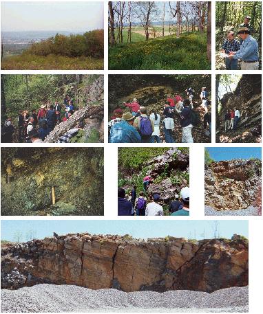
The 2002 ATSG field trip was held May 10 - 12 in south central Pennsylvania . Nick showed us evidence for Alleghanian sequential deformation expressed in the counter-clockwise rotation of layer-parallel shortening or vergence directions and coincident change in the nature of fault fabrics. Saturday May 11 was spent traversing the Big Cove anticline and Sunday May 12 was spent in the Path Valley. Seven of the stops are marked on the index map.
Click on any image to enlarge it
|
|
|
Field Stops
Stop 1 Array of conjugate strike-slip faults in the Keefer SS define the pre-folding layer-parallel shortening direction. Land owners are John and Sonja Blattenberger.
Stop 2 Lunch Stop
Stop 3 An outcrop of the Antes/Coburn detachment. A pre-folding, thin cleavage duplex in the Antes Shale at the top of the Ordovician carbonate section shows early fault transport and a marked strain discontinuity.
Stop 4 The steep, reverse Cove Fault displayed in a megabreccia where the Tuscarora Qtzt. is distributed along the fault zone in brittle, separated blocks floating in more ductile shales and sandstone of the Ordovician, Silurian and Devonian. An example of the the last stage of Alleghanian deformation.
Stop 5 Mellott carbonate quarry showing evidence of pre or syn-folding shortening directions. We also crossing the Cove Fault and walked through a vertical Ordovician to Middle Devonian section showing significant thinning.
Stop 6 A newly discovered normal fault that splays off the Cove Fault and parallels it for 3 miles. An important feature is Cambrian carbonate and Gatesburg sandstone, the oldest rocks in the Big Cove anticline, that are obliquely truncated against the Cove Fault.
Stop 7 – Shows a magnificent array of fairly well exposed Az. 50-60 degree trending fault blocks with repeated right-lateral separations of the Tuscarora-Juniata-Bald Eagle section. The Az. 50-60 fault blocks are bounded by fault surfaces that show no slickenlines, that could provide slip directions. The surfaces are not slickensided but are recognized as fault surfaces because they terminate outcrops and, in some places, contain iron-oxide staining and small patches of breccia. Within beds of Bald Eagle sandstone truncated by these late faults it is possible to find remnants of the early strike-slip faults seen at Stop 1.
Published topographic and geologic information for the region
The area where we will spend the weekend is divided up between three 1:250,000 quadrangles – NE corner Cumberland, NW corner Baltimore, SW corner Harrisburg. I have mapped on parts or all of the following 7.5 minute quadrangles: Big Cove Tannery, Burnt Cabins, Cherry Run, Doylesburg, Fannettsburg, Meadow Grounds, McConnellsburg, Mercersburg, and Shade Gap.The region is well represented on the 1980 edition of the Geologic Map of PA. George W. Stose prepared a map of the 15 minute Mercersburg quadrangle, including the Mercersburg and McConnellsburg 7.5 minute quadrangles, during 1901-1907 which was published in the USGS Folio series.
The most recent published mapping was:
Pierce, Kenneth L., 1966, Bedrock and Surficial Geology of the McConnellsburg
Quadrangle, Pennsylvania, Atlas 109a, PA Geological Survey, 4th
series. AND Okuma, Angelo, 1970, Geology of the carbonate rocks of Path Valley,
Franklin County, PA, Progress Report 179, PA Geological Survey, Okuma shows
the fold in the carbonate section which is truncated by the Path Valley steep
reverse fault.
Gwinn 1964, GSA Bulletin, v. 75, p.863-900 drew a regional section through the McC area and this was followed by another section by Mitra, S. and Namson, J. 1989, A.J.S. v. 289, p. 563-599 along essentially the same line.
In a different context,
Root, S.I. and Hoskins, D.M. 1977, Lat 40 N fault zone, Pennsylvania: A new
interpretation, Geology, v. 5, p.719-723 have described a major E-W system
of faults that enter this region from the west along the Pennsylvania
Turnpike.
Markley, M., and Wojtal, S., 1966, Mesoscopic structures, strain, and volume loss in folded cover strata, Valley and Ridge Province, Maryland: American Journal of Science, . v. 296,have demonstrated sequential deformation: a pre-folding early dissolution cleavage trending Az.55 is overprinted counter-clockwise by folding that trends Az. 28 at a locality along Rt. 40 in MD, 35 miles WSW of the Big Cove valley.
Richard Nickelsen,
Bucknell University, Emeritus