![]() 2 Known and 6 Suspected Large-Bolide Impacts on Earth, with Plate
Boundaries and Current GPS Plate Horizontal
Velocities.
2 Known and 6 Suspected Large-Bolide Impacts on Earth, with Plate
Boundaries and Current GPS Plate Horizontal
Velocities.
Click here to download the Google Earth KMZ implementation of this map (GPSmotions.kmz 1KB)
Far-field strains on Earth from 2 known (Chicxulub and Chesapeake) and 6 suspected impact sites (Canada basin, Congo basin, Mid-Pacific Mountains, Norfolk basin, Shaanxi, South Georgia) are shown below. Splash rings are shown using colored line traces at 660, 1550 and 2900 km radius around each impact. The rings trace circumferential regions of uplift and subsidence around each site. Black vectors show current, horizontal azimuth and magnitude of tectonic-plate motions based on NASA JPL GPS data. Vector lengths are variably-scaled with the horizontal velocity for each GPS station multiplied by 0.25 geographic degrees. The average horizontal velocity for the crustal plates is about 27 mm/yr based on time-series data for 778 GPS stations. Station points are color coded blue for stations having negative vertical motion (subsidence) and green for positive (uplift), respectively. Red-dashed lines originate at impact craters and extend foreland of each crater in the direction of crustal compression; in line with interpreted paths of oblique descent for the different projectiles. The thin-dashed, colored lines trace surface features including ocean-floor transform faults and other continental lineaments that highlight crustal fractures and faults that either stem from far-field strains associated with the different impact events, or are perturbed by them. Tectonic-plate boundaries are shown as thick maroon and black lines. The thin gray lines on the sea floor trace the M34 magnetic isochron.
Click on the image for higher resolution
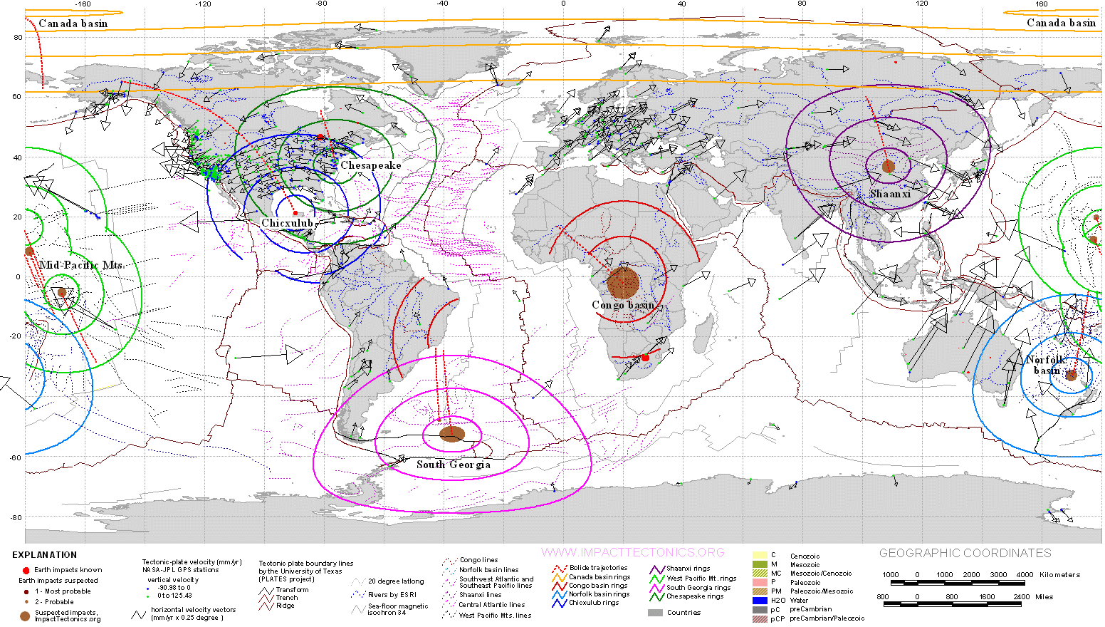
Plate motions worldwide currently diverge northward away from the suspected
South Georgia impacts
in the Southwest Atlantic Basin. Exceptions are plate motions associated
with the Chicxulub impact and a suspected (Middle Paleozoic?) impact in the
Shaanxi province of China. In both of these latter instances, plates pivot
around impact sites. These relationships are intended to show that large
impact events produce long-lasting geodynamic responses, probably operating
to dissipate energy fluxes imparted by large-impact events. Moreover,
most of these impacts show nearby fragmentation of tectonic plates, especially
in hinterland regimes of crustal extension. Large-bolide impacts therefore
appear to drastically influence Earth geodynamics to a degree that we are
only beginning to realize. The South Georgia event may have occurred in the
Middle Miocene during the Langhian (13.65–15.97 mya) stage when there
was a sudden
warming
trend in Antarctica (~15.7 mya ), changes in Atlantic and Pacific
ocean
circulation, and subsequent
extinction
waves of terrestrial and aquatic life forms (~14.8 to 14.5 mya).
The distribution of tektites
in the North American tektite strewn field also shows a remarkable spatial
coincidence with the proposed foreland trajectory of the Argentine impact
even though it is currently thought to stem from the Chesapeake impact of
Eocene age (~35 Ma).
![]() www.impacttectonics.org
03052008
www.impacttectonics.org
03052008