Oblique-Impact Complex on Mars including Syria and Sinai Planum Rev. 2016-03
![]() IMPACTTECTONICS.ORG
IMPACTTECTONICS.ORG
Oblique-Impact Complex on Mars including Syria and Sinai
Planum
Rev. 2016-03
Syria Planum and Sinai Planum lie at the center of a complex crustal
structure interpreted
to be the result of a multiple, hypervelocity
(> 6 km/sec) impact event on Mars. Syria
Planum is shown to be a composite,
asymmetric crater formed by impact of at least two
bolides whereas Sinai
Planum is the result of a chain of tightly-clustered impacts
(fig. 1),
perhaps from a frgameted cluster of bolides or partly the result of spalled projectiles
(Schultz and Gault,
1990). The impact complex is portrayed below as having tectonic
elements
including a circumferential crustal welt, a compressed foreland wedge and an
extensional strain regime in it's wake where Olympus
Mons and Tharsus Montes
volcanisim lie (fig. 1).
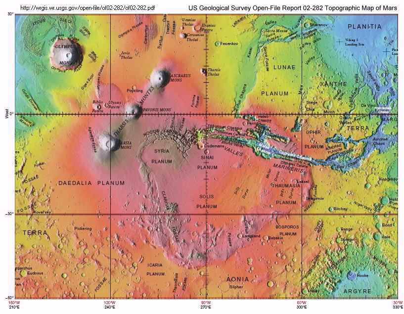
Figure 1. Part of the Topographic Map of Mars (2002) centered on the Syria,
Sinai,
and Solis Planums.
Click on the central
part of the image for a more detailed view.
A set of craters located between longitudea 20o
to 60o W and 0o to 30oS latitude are
centered in a crustal
welt having about 135o surface span. Other
tectonic features include
near-crater fracturing and symmetric topographic ridges fanning outward from
the wedge
apex toward a prominent foreland scarp. Solis Planum and Thaumasia
Planum are probably
plateaus along with other foreland fault scarps forming the toe of the crustal wedge.
Details of the proposed craters are capture in figure 2. Figures
2a (uninterpreted), 2b
(interpreted), and 2c show a series of faint outer
rims within Syria Planum that probably
result from multiple, overlapping
oblique impacts. Figure 2d covers the Tharsis Montes
region and the symmetry
of the volcanisim with respect to the crater complex. The
horizontal
component of the bolide trajectories as modeled in figures 3 and 4 are based on
crater alignment.
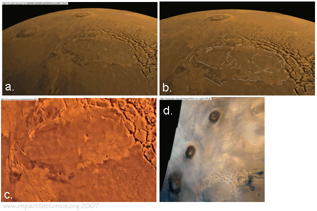
Figure 2. NASA photographs showing details of the crater region.
Figures 3 and 4 include primitive and rendered views of the impact complex
mapped in
kilometers using AutoCad software. Map sectors are
defined relative to the impact
center that include compressional (C), extensional
(E), and marginal (M) regions. The
compressional region of crustal wedging
lies foreland of the craters in the direction
of the inferred flight
trajectories. The model shows a set of three overlapping wedges
having structural
components including lateral shear fracture systems, topographic
ridges,
and crustal scarps associated with crustal thickening and uplift. Valley
Marineris
flanks the compressional wede to one side and coocides with a fault zone
of intense
crustal fracturing, although this well known crustal feature has
a complex structutal
history including other impact overprints.
The volcanic center of Olympic Mons and Tharsis Montes occupy the crater
hinterland
where the crust
and mantle were extended with steeply-dipping extension fractures
that
needed to penetrating
to mantle depths in order to initiate decompression melting
and generation of mantle melts that subsequently ascended along these fracture
that
fed the
volcanoes. The inferred fractures are now buried beneath
volcanic flows. Even
the
alignment of Tharsis Montes belies the strike angle and concomminant extension
directions lying approximatley normal to the bolide flight trajectory (fig. 3).
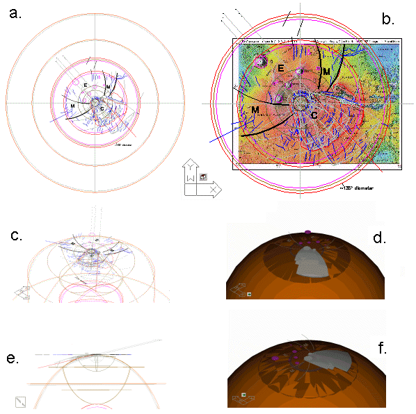
Figure 3. AutoCADR14 model of the impact complex. Click on any image for more details.
Marginal regions have the lowest topographic elevations in the circumferential
crustal welt and correlate to areas that probably contain near-impact ejecta
and
crustal fractures having a different trend from those in the compressional
region.
The diameter of the circumferential welt roughly corresponds
to the diameter of
the Martian core (1700 km) as detailed in profile (fig.
4). The crustal welt is also
cut by arcuate lineations assumed to parallel
fracture dispersed in front of the
impacts, as ripple marks cast in front
of a stone splash. The bolide angle of descent
is modeled below as being
about 30o from horizontal, although this is highly
speculative.
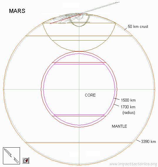
Figure 4. Profile diagram of Mars showing the geometric relations
associated
with the proposed impact structure.
Two global perspectives of the impact complex are shown in figure 5 using
NASA's Mars
Global Surveyor, orbital laser altimetry (fig. 5a) and gravity
(5b) data. Digital traces
of geological structures from the Viking Orbiter-based
geologic maps of Mars are
superimposed on the geophysical coverage that include
undifferentiated grabens,
calderas, wrinkle ridges, channels, crustal scarps,
depressions, and crater rims (Skinner
and others, 2006).
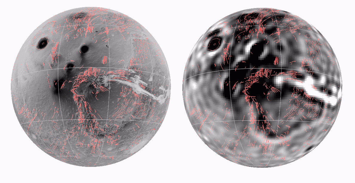
Figure 5. Mars Global Surveyor altimetry (left) and gravity (right) data
rendered
using ESRI ArcGlobe. Click on any image for more details.
The composite set of tectonic features are proposed to result from impact
shock, crust
and mantle fracturing and upheaval, and perhaps relaxation.
Here, the impact tectonic
features are frozen in time due to the lack of
active orogenic processes that would
otherwise mask such effects.
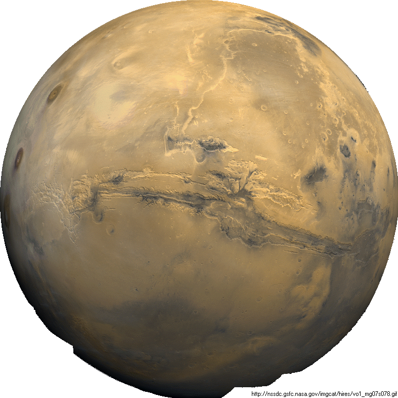
Figure 6. NASA Viking Orbiter image showing global view of
Sinai Planum and Valley
Marineris and other components of the proposed impact
complex. Click on the image
for a more-detailed view.
This impact event created a huge energy flux and solid-body disturbance on
Mars,
that genrated body waves that reflecting and refracting
off major phase boundaries
in the planet's interior while leaving telltales
scars of brittle deformation at the surface.
The nature of the mantle deformation
necessary to produce such a crustal signature
is only speculative but may originate
from primary reflections of compression waves
gnerated by impact and
resounding off the core-mantle boundary
back to the surface
to produce giant concentric welts welts in the planetary
lithopshere. Similar geometric
relationships are seen on Earth for known
(Herman, 2006) and suspected
(Cuvette Central
of Rajmon, 2007) impacts, among other supsected ones. The
relative timing and
development of the various ductile and brittle strains
and associated volcanic activity
are also unknown. However, most of the brittle
crustal disturbance must have been
relatively instantaneous with both ductile
flow and igneous activity ensuing. It's
possible that tectonic activity in
the form of mantle plumes, perhaps even mantle
dynamics with associated crustal
stains persist today, thereby reflecting long-lasting
regional strain effects
from this catastrophic event.
REFERENCES
Herman, G. C, 2006, Neotectonic setting of the North American Plate in relation
to the
Chicxulub impact: Geological Society America Abstracts with Programs,
Vol. 38, No. 7, p. 415
Rajmon, David , 2007, Suspected Earth Impact Sites database, April 13, 2007:
Shell,
Houston, TX, USA. http://eps.utk.edu/ifsg_files/SEIS/SEIS_database9.xls
(Excel 708KB).
Schultz, P. H. and Gault, D. E., 1990, Prolonged global catastophes from
oblique
impacts in Sharpton V.L., and Ward, P.D., eds., Global catastrophes
in Earth history;
An interdisciplinary conference on impacts, volcanism,
and mass mortality: Geological
Society of America Special Paper 247, p. 239-261.
Skinner, J. A., Jr, T. M. Hare, and K. L. Tanaka 2006, Lunar and Planetary
Science
Conference XXXVII, abstract #2331
![]() G.C. Herman,
www.impacttectonics.org Rev. 2016-03-05 / 2007-10
G.C. Herman,
www.impacttectonics.org Rev. 2016-03-05 / 2007-10