• Immediately precedes the Moskovian/Kasimovian boundary
and the Carboniferous Rainforest Collapse.
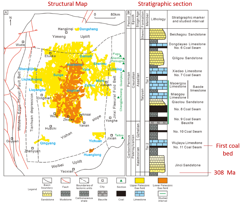
• First coal measures in the Ordos are late Kasimovian
• GPS Horizontal plate-motions show that the Himalayas have been stacking up
against the strain-hardened core of the astrobleme for over 300 Ma with basin
and mountain augmentation from plate orogenesis.
• All prior bedrock was shock fractured
• This impact event established the tectonic framework of China’s Mesozoic and
Cenozoic depositional Basins
• Probably a high-angle impact of a large, km-scale asteroid based on micro
spherules of that age found in Russia (Sungatullin and others, 2017)
Figure 1 of Hao and others (2023).
Since 2010 the Tarim Basin has produced over 7.7 billion of barrels of oil from Lower and Middle Paleozoic ultra deep reservoirs drilled to 5800 to 8000 m. These reservoirs produce from fracture porosity with the most productive plays located within 1000 m of major faults. The tectonic effects of large-bolide impacts together with ordinary plate orogenesis and thermal maturation models help explain why, where, and when hydrocarbons in the basin were produced, mobilized, and trapped.
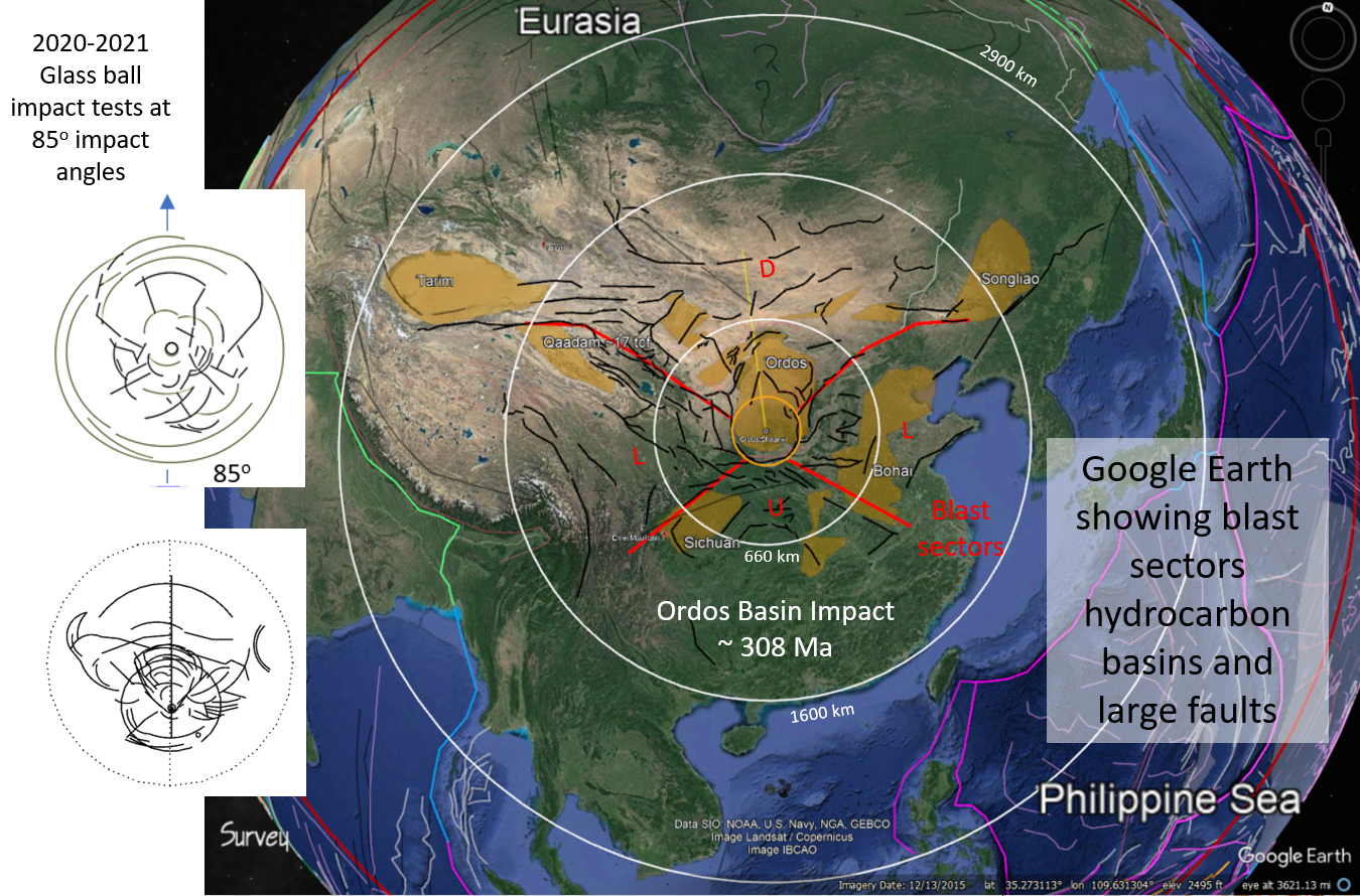
Two km-scale, meteor impact events may have significantly affected the structural geology of the Tarim basin: 1) A suspected Late Paleozoic Ordos impact event of Carboniferous age (~308 Ma) that helped established the tectonic framework of the central Asian platform and, 2) A suspected Early Cenozoic, Mid-Eocene (43.5 Ma) impact that may have directly impacted the Tarim basin (Buthman, 2022). The suspected nature of these impacts is based upon geological map patterns, gravity and magnetic field intensities, physiography, crustal-stress regimes, and GPS ground-fixed, plate-motions (fig. 2). The first impact event likely set the stage for hydrocarbon basin development in the region because large-scale faulting and geological symmetry is consistent with impact-tectonic far-field (ITFF) strains produced by a high-angle impact directed northward in line with the Ordos basin axis.
Click on an image for more detail


 +
+

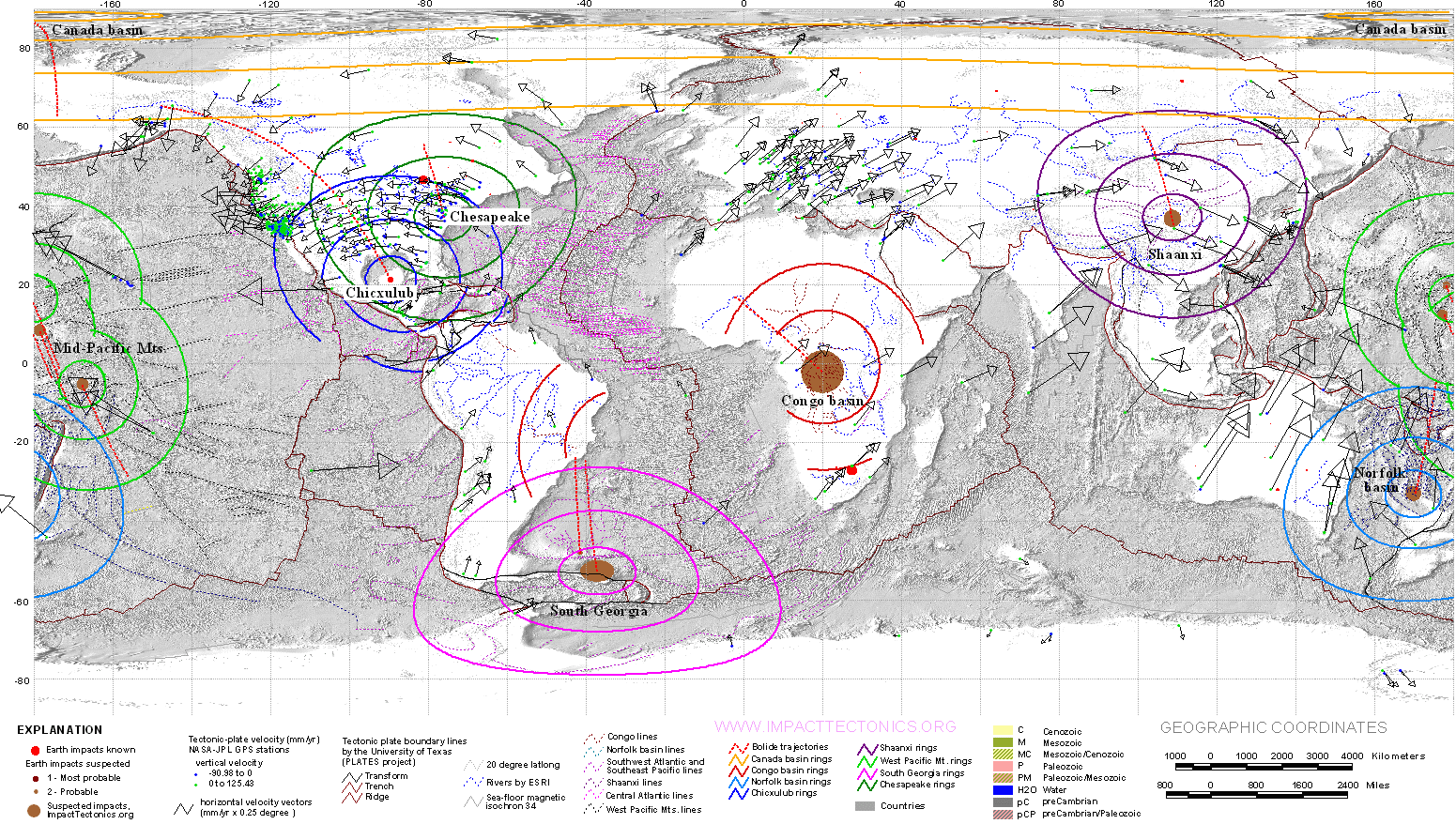
Figure 2. The Ordos astrobleme is centered on the Ordos Basin, China and likely resulted from a km-scale asteroid impact having a northerly heading and a very steep impact angle. The Himalayan Mountains are stacking up against the west side of the basin within a lateral blast sector. The region shows focused tectonic thickening and uplift down range that opposes crustal stretching with magmatism up range. The hydrocarbon basins of China show systematic spatial distribution relative to the Ordos basin, with the Tarim and Songliao basins developed at the lateral margins of the down-range strain sector. Continental geology by Era theme by Herman (2014), gravitational-field intensity theme by Maus and others (2009), magnetic-field intensity theme by NOAA (2017), and the physiographic theme by Amante and others (2008). GPS-based plate-drift vectors are shown in white with the phsiography theme. Blast sectors; D - Down range. U - Up range, L - Lateral
The structural expression of the suspected Ordos astrobleme is remarkably consistent with impact strain fields produced at very-high impact angles in little glass balls (fig. 3; Herman, 2022). All prior bedrock was shock fractured, and micro spherules from a stony meteorite of Moscovian age occur in the Cisuralian foredeep of Russia (Sungatullin and others, 2017). The Tarim basin sits at the farthest, western reaches of the ITFF down-range strain sector and is mirrored to the east by the Songliao basin. In this scenario, the impact would have established the tectonic framework for successive basin augmentation through ordinary plate-drift and orogenesis. The Ordos (or Shaanxi) basin is only one of two large basins on Earth that show systematic plate-tectonic rotations around large petroleum basins, with the Gulf of Mexico being the other. The Himalayan mountain range appears to have been stacking up against the strain-hardened core of the Ordos astrobleme for the past 300 Ma. A second, suspected impact may have alternatively directly formed the Ordos Basin as proposed and illustrated by Buthman (2022). Seismic data on the northwest margin shows asymmetric folding with vergence towards the center of the basin center.

Figure 3. Top (upper) and side (lower) views of a strain field produced in a glass-ball by a very high-angle impact. The impact heading is toward the top in the top view.
References
Amante, C. and Eakins, B. W., 2008, ETOPO1 1 Arc-Minute Global Relief Model: Procedures, Data Sources and Analysis, National Geophysical Data Center, NESDIS, NOAA, U.S. Department of Commerce, Boulder, CO, www.ngdc.noaa.gov/mgg/global/relief/ETOPO1/docs/ETOPO1.pdf.
Buthman, D. B., 2022, Impact crater tectonics; The future of resource exploration: Impact Crater Studies Group, 285 p. ISBN: 979-8-9853971-0-0
Herman, G. C., 2022, Punctuated Tectonic Equilibrium, www.impacttectonics.org. 202 p.
Hou, Z., Chen, S., and Liang, Z., 2023, Sedimentary features and sequence stratigraphy of the successions around the Carboniferous-Permian boundary in the Ordos Basin: links to glacial and volcanic impacts: Journal of Palaeogeography, v. 12, No. 3, p. 353 - 383.
Maus, S., Barckhausen, U., Berkenbosch, H., Bournas, N., Brozena, J., Childers, V., Dostaler, F., Fairhead, J.D., Finn, C., von Frese, R.R.B., Gaina, C., Golynsky, S., Kucks, R., Lühr, H., Milligan, P., Mogren, S., Müller, D., Olesen, O., Pilkington, M., Saltus, R., Schreckenberger, B., Thébault, E., and Caratori Tontini, F., 2009, EMAG2: A 2-arc-minute resolution Earth Magnetic Anomaly Grid compiled from satellite, airborne and marine magnetic measurements: Geochemistry, Geophysics, Geosystems, Technical Brief, vol. 10., no. 8., 12 p., doi:10.1029/2009GC002471, ISSN: 1525-2027.
NOAA, 2017, EMAG2v3: Earth Magnetic Anomaly Grid (2-arc-minute resolution): U.S. National Centers for Environmental Information (NCEI) sourced as www.ngdc.noaa.gov/geomag/data/EMAG2/UpCont_shade_KMZ.kmz.
Sungatullin, R. K., Sungatullina, G. M., , Glukhov, M. S., Tselmovich, V. A., Bakhtin, A. I., Kuzina, D. M., Gusev, A., 2017, Cosmic dust in the deposits of the the Moscovian and Kasimovian stages, Usolka Section, Cisuralian Foredeep, Russia: Vol. 80th Annual Meeting of the Meteoritical Society 2017 (LPI Contrib. No. 1987) 6121.pdf