![]() TECTONICS BLOG
Rev. 2024-04-04 www.impacttectonics.org
TECTONICS BLOG
Rev. 2024-04-04 www.impacttectonics.org
Gregory Charles Herman, PhD, Flemington, New Jersey, USA
Introduction * Review * Eighteen lunar astroblemes * Seismological aspects * The South Pole - Aitken basin * Maria Imbrium and Serenitatis * Mare Nectaris * Mare Crisium * Mare Orientale * Mars and Earth models * Discussion * References * GE Pro Moon KMZ file
|
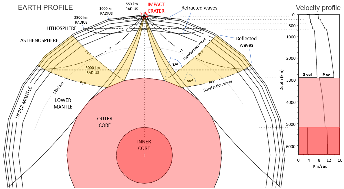
Click on an image to enlarge it Two large bolide strain fields mapped on the North American tectonic plate using GE Pro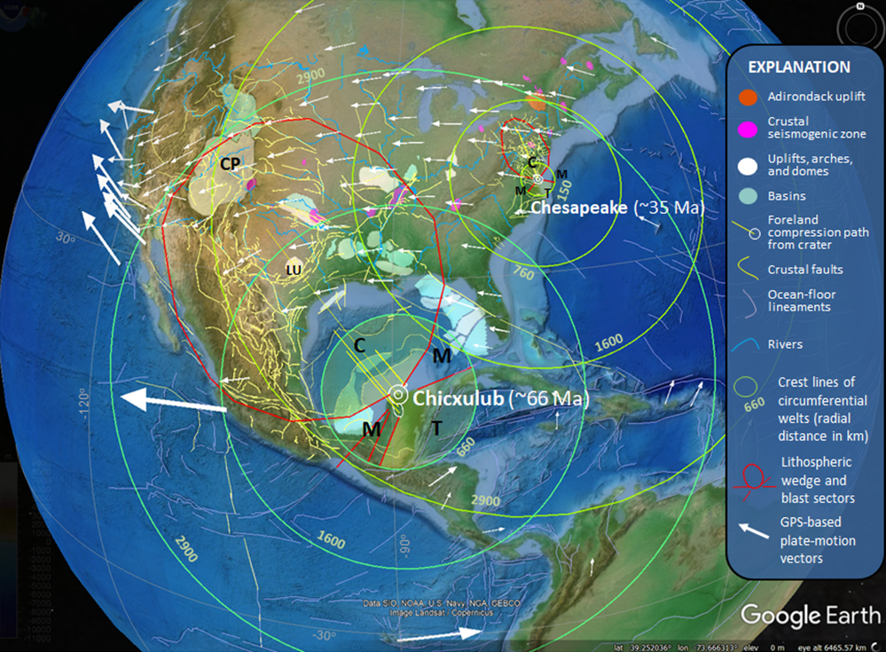 Figure 1. ITFF crustal-strain fields mapped around two large impact craters on the North American tectonic plate. Circumferential blast patterns drawn around each crater include strain sectors dominated by compression and reverse faulting (C - down range), tension and normal faulting (T - up range), or mixed-mode (M) faulting within lateral sectors. Radial arching of the lithosphere is traced around each crater at 660, 1600, and 2900-km radii. The compressed foreland has thickened upper mantle and crust downrange of the crater where grounded impact energy is focused and refracted back to the surface at great distances. Crustal seismogenic zones mapped inside 90oN to 90oS latitudes and 30oE to 150oW longitudes mapped by Herman (2006). Mapped basins and uplifts mapped from Trehu and others (1989), Pindell and Kennon (2009), and Ewing and Lopez (1991). LU – Llano uplift. CP – Colorado Plateau. ETOPO1 surface base theme from Amante and Eakins (2008). 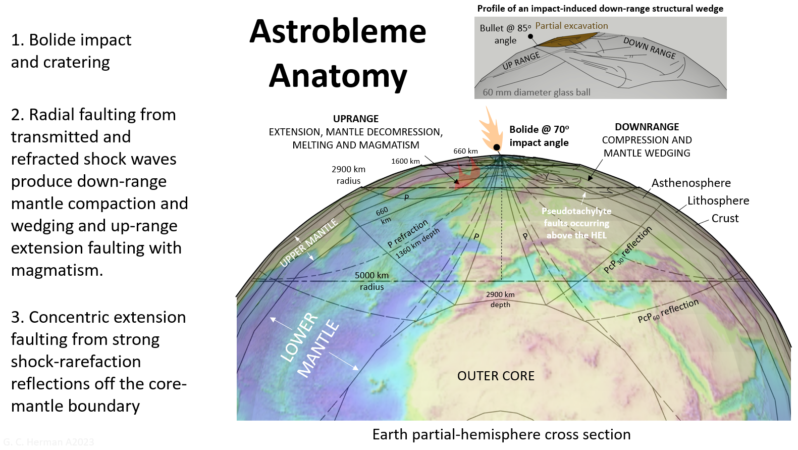 Figure
2
Large, km-scale meteorite impacts on Earth produce
enormous amounts of grounded shock energy resulting in far-field strains
in the upper mantle and crust reaching thousands of kilometers distance
from craters. Experimental
results from impact tests using small glass balls and seismological ray
paths for compressional body waves (P-waves) help constrain the geometry
of planetary-scale impact-tectonic, far-field (ITFF) strains (adapted
from Herman, 2022). The Earth model is part of a SU Pro CAD model. Figure
2
Large, km-scale meteorite impacts on Earth produce
enormous amounts of grounded shock energy resulting in far-field strains
in the upper mantle and crust reaching thousands of kilometers distance
from craters. Experimental
results from impact tests using small glass balls and seismological ray
paths for compressional body waves (P-waves) help constrain the geometry
of planetary-scale impact-tectonic, far-field (ITFF) strains (adapted
from Herman, 2022). The Earth model is part of a SU Pro CAD model.Target and projectile impact parameters 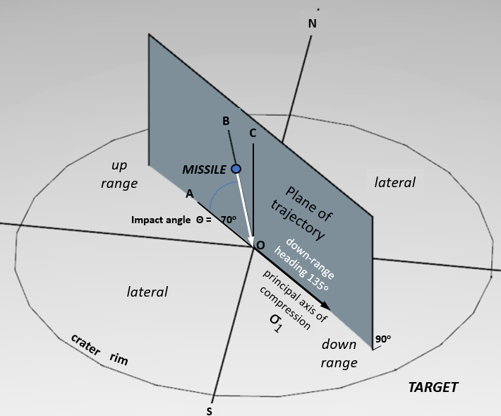
Figure
3.
Model
parameters for an oblique impact including a missile, target, impact point (O) and
impact crater. AO is horizontal to ground surface at the impact point,
CO is vertical, BO is the missile trajectory (impact angle
Θ =
70o). Four equidimensional blast sectors include two up- and
down range ones and two lateral ones split along the plane of
trajectory. Real blast sectors are disproportional and skewed by
impact obliquity and inherited compositional and structural heterogeneity of target materials.
Headings are horizontal in the plane of trajectory measured down range
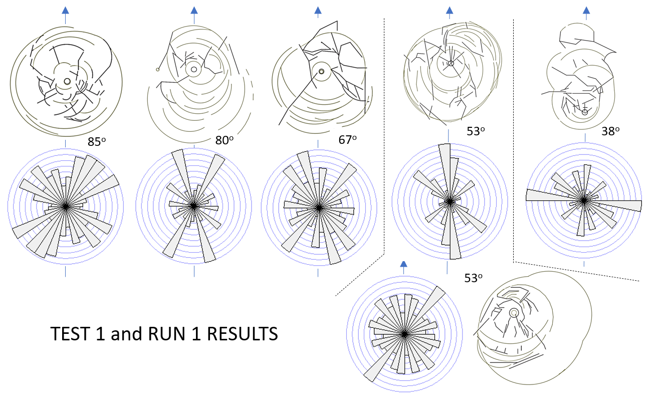
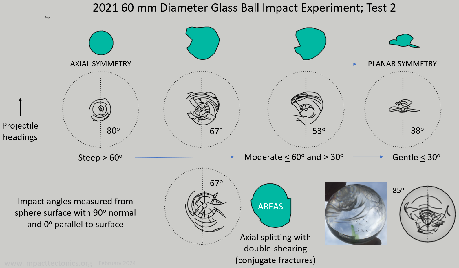
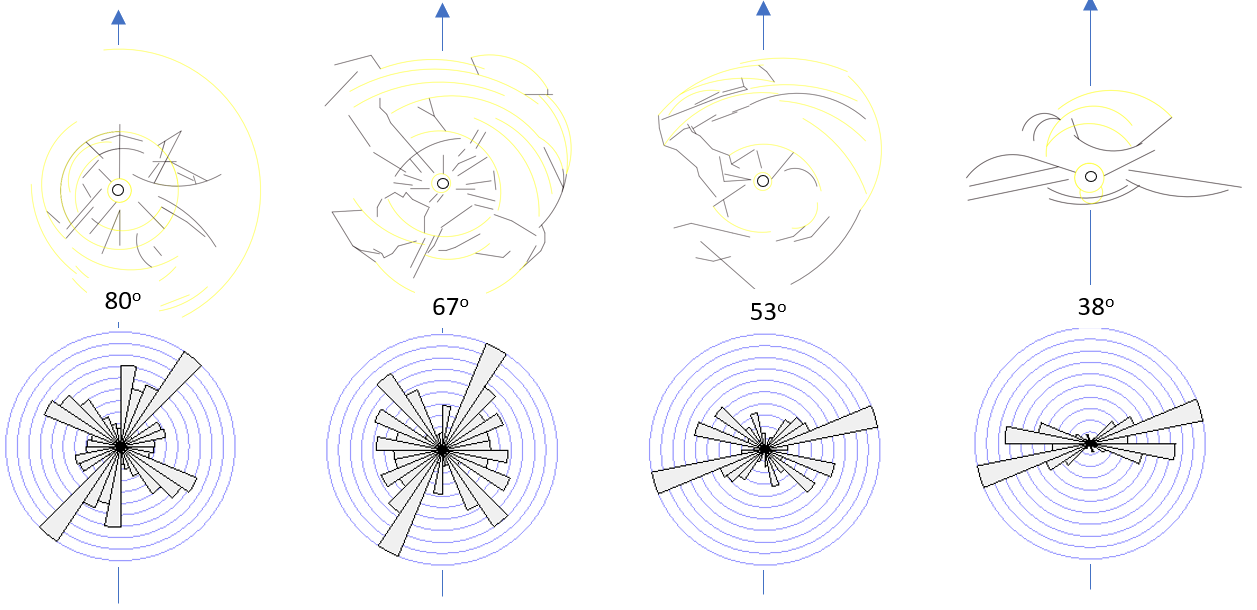
relative to geographic north. Fracture strikes, patterns, and strain areas from glass-ball impact tests conducted at high (>60°), intermediate, and low (<30°) angles
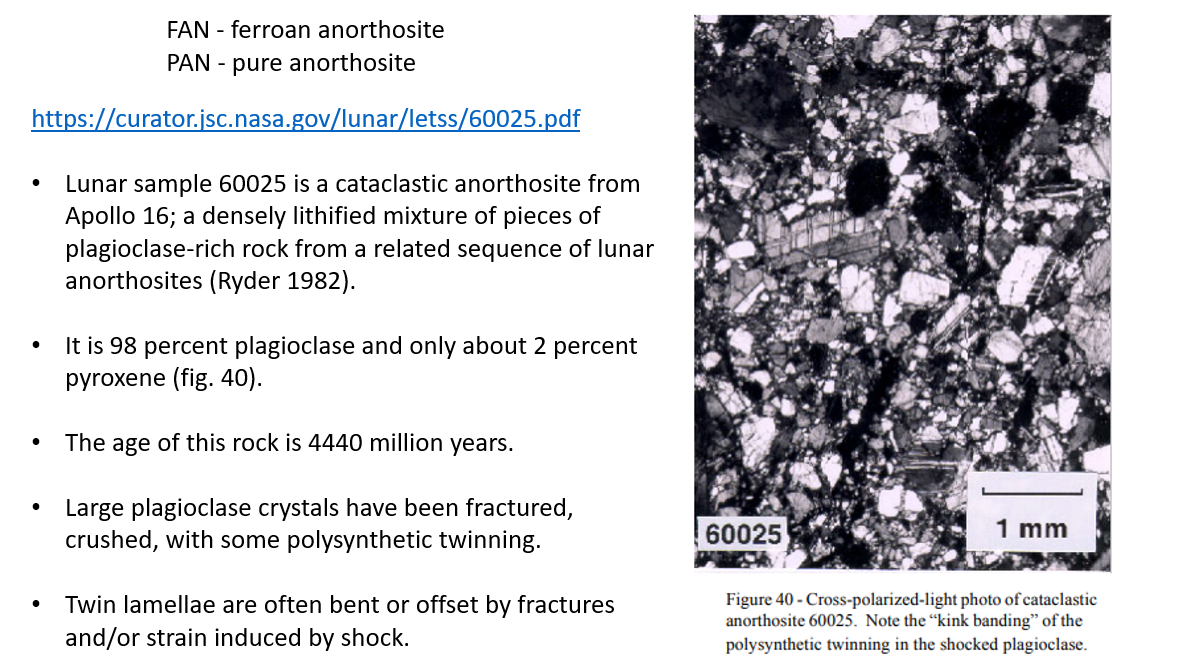
Lunar chronology and Apollo anorthosite sample 600025 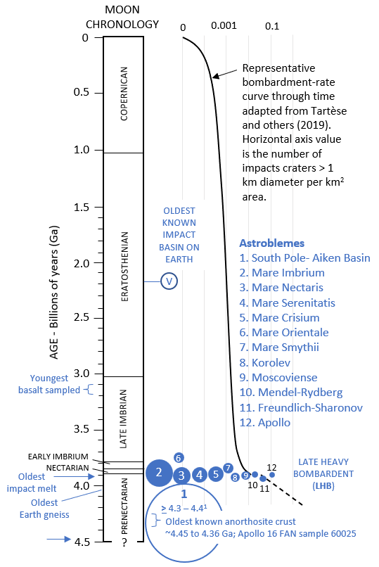
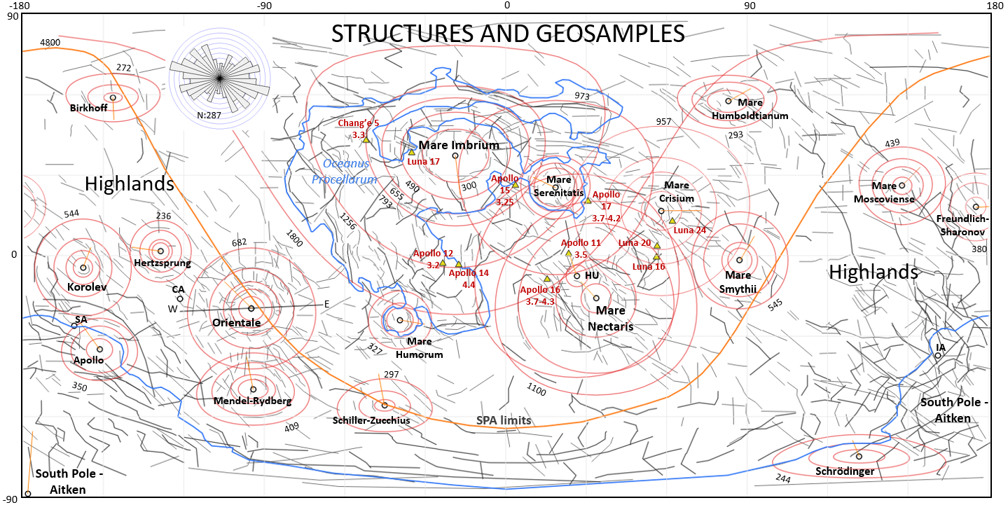
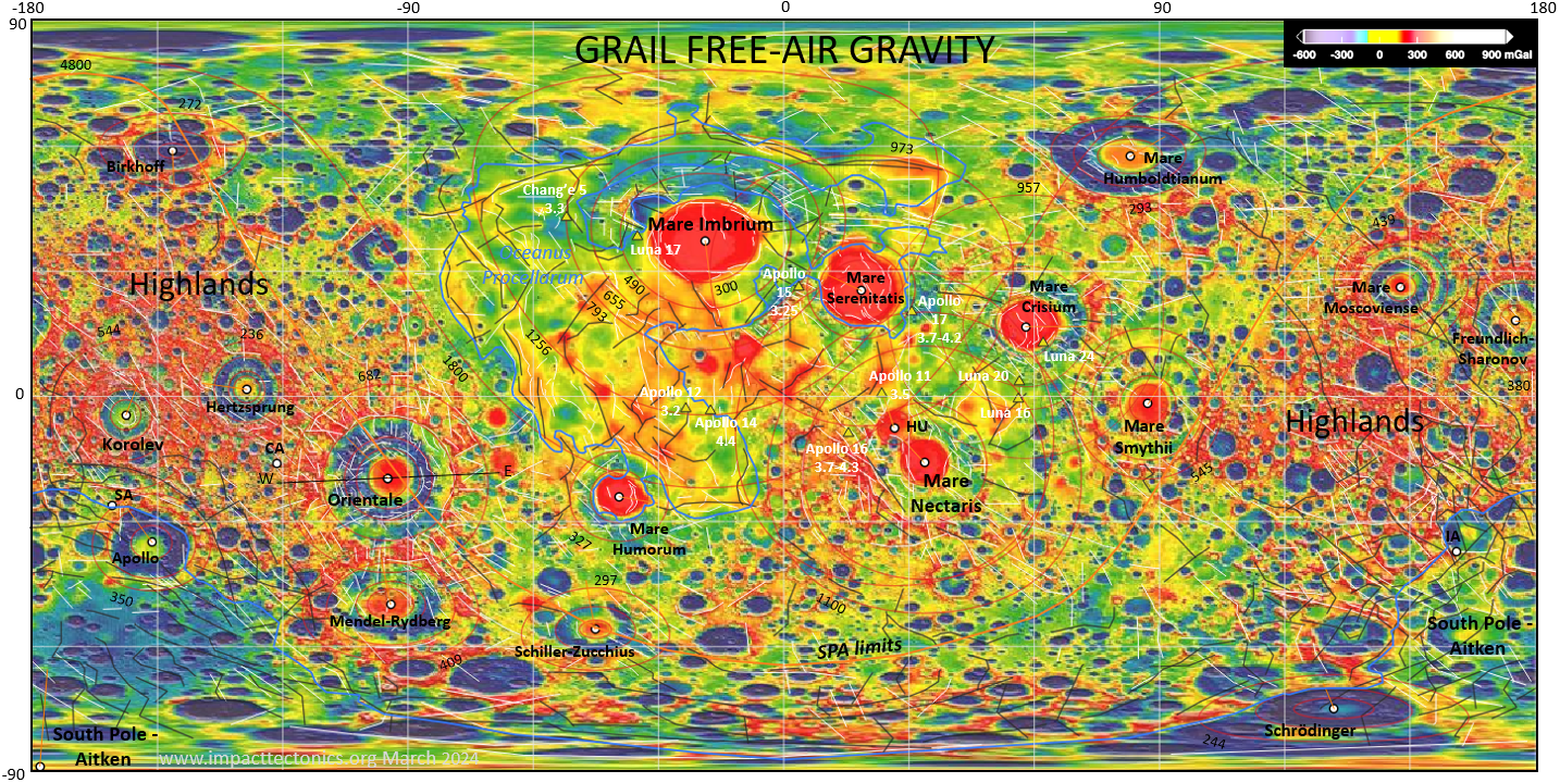
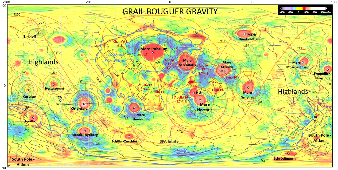
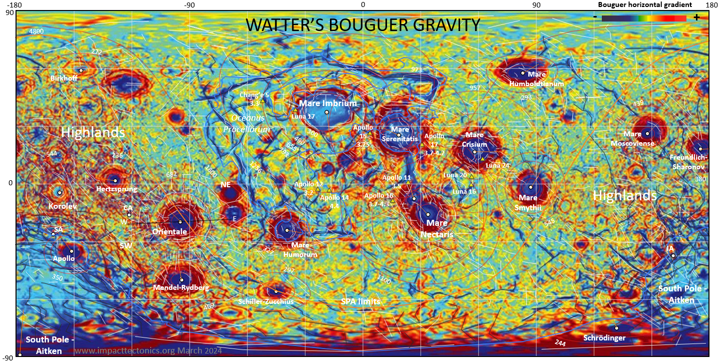
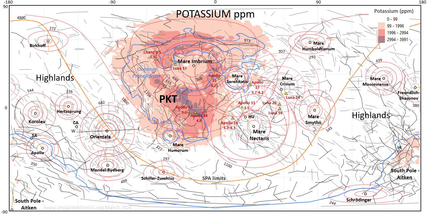
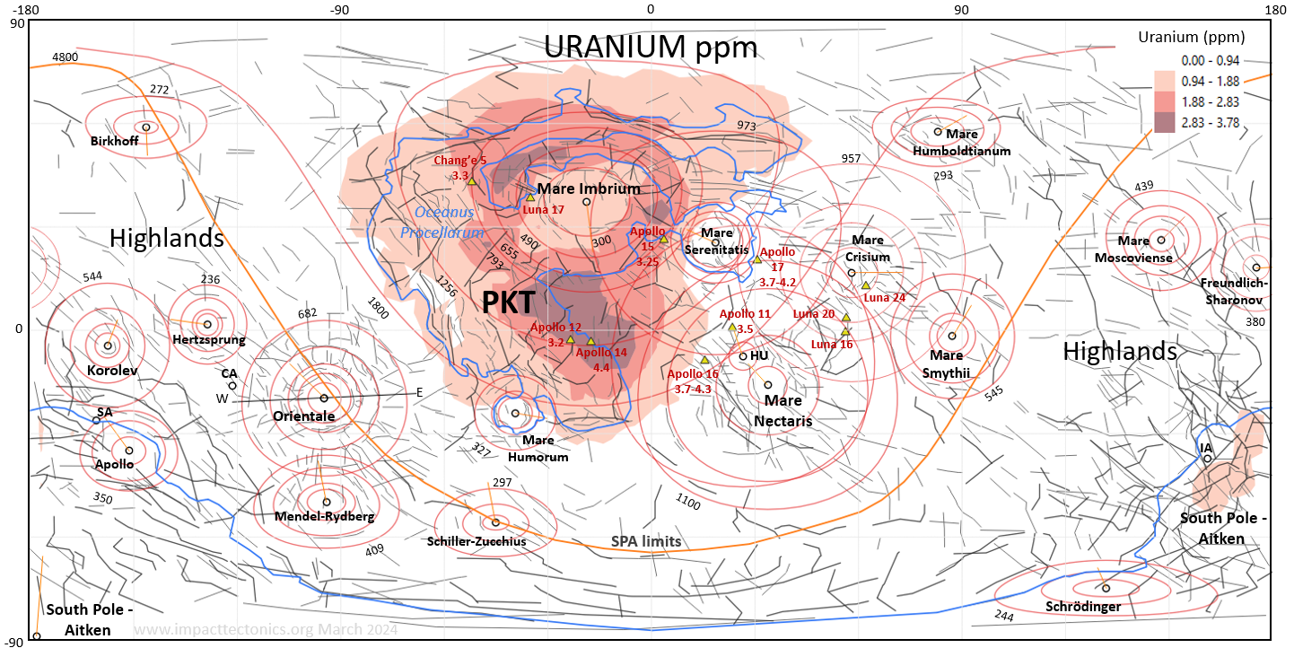
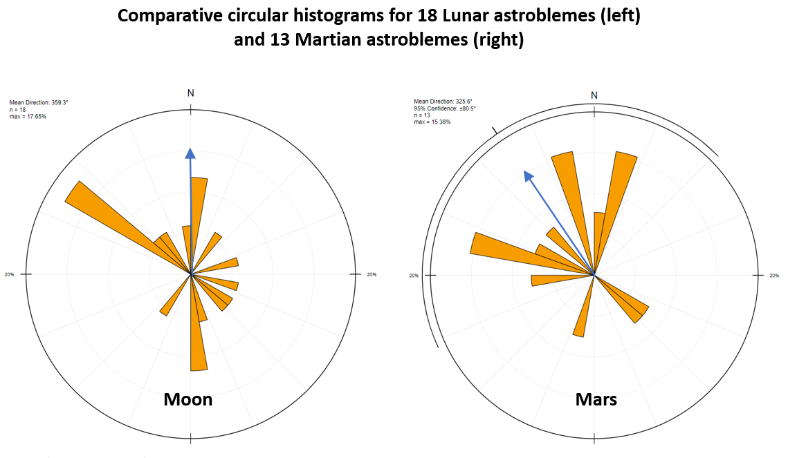
Figure 5. Top - Lunar chronology including large impact basins with temporal placement and symbols scaled to outer-ring diameters (table 1). Twelve of the largest basins mapped in figure 6 are represented, most of which are thought to occur during a Nectarian and Early Imbrium period of heavy bombardment (~3.8 to 3.9 Ga). Basin ages and bombardment-rate curve adapted from Tartèse and others (2019) and Stöffler and Ryder (2001). Note the clustering of ages of the oldest impact melts and the oldest gneiss on Earth. 1 Age of the SPA from Morbidelli and others, 2012). The open circle labeled “V” represents the Vredefort impact crater (2.02 Ga), the oldest confirmed impact crater on Earth (Allen and others, 2019). Bottom - Apollo 16 surface sample 600025 photomicrograph and facts.Table 1. Locations, sizes, and interpreted headings of eighteen lunar astroblemes (fig. 5). Cells highlighted gray fall within +10% deviation of calculated ring dimensions using a Ö2 scaling ratio for adjacent rings. This ratio suits 64% (9/14) of outer rings 4 to 6, 33% (12/36) of inner rings 2 and 3, and 42% overall (21/50). 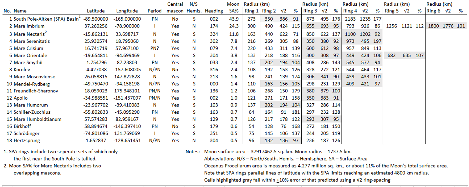 The structure of eighteen lunar astroblemes in geographic space using eleven geospatial themes 6A. NASA Digital Terrain Model 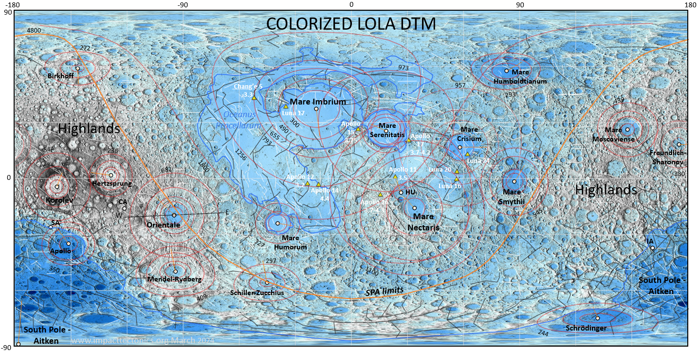
6B. Structures and Geosamples
6E.
Bouguer Gravity (Watters, 2022)
6F.
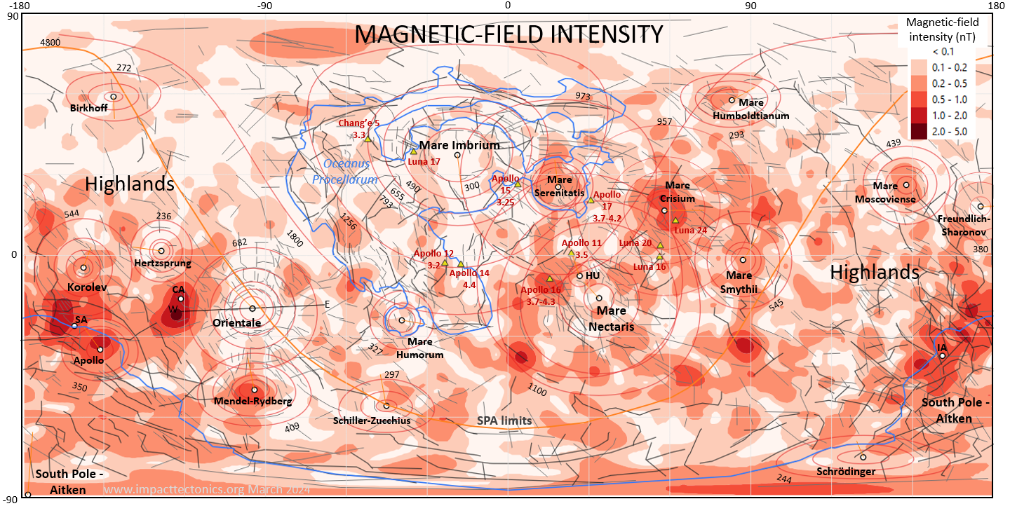
JAXA SELENE Magnetic-Field Intensity
6G.
NASA LP Spectroscopy - Silicon
6H. NASA LP
Spectroscopy - Aluminum
6I. NASA LP Spectroscopy
- Iron
6J.
NASA LP Spectroscopy - Potassium
6K. NASA LP Spectroscopy
- Uranium
6M Circular histograms of
large-bolide headings Figure 6. Top - Eighteen multi-ring astroblemes mapped in geographic space using 11 geospatial themes. Maps include a colorized NASA DTM (5A), GRAIL free-air (5B) and Bouguer (5C) gravity, large faults and geosamples (D, a Bouguer gravity gradient map (5E) by Watters (2002), SELENE magnetic-field intensity (5F), and LP spectroscopy themes of elemental abundances in shallow ground for silicon (5G), aluminum (5H), iron (5I), potassium (5J), uranium (5K) and thorium (5L). Each multi-ring structure is labeled and includes concentric rings of variable radii corresponding to radial and concentric crustal features and ITFF strain limits. Ring dimensions and bolide headings summarized in table 1. Rings radii labeled for the Aiken and Mare Imbrium basins. Outer ring radii labeled for all other basins. NASA and JAXA data sources explained in the text. The orange line labeled SPA limits and large-basin limits are interpreted boundaries used for calculating basin and astrobleme areas. Bottom - Interpreted bolide headings are statistically tallied and compared to large-bolide headings mapped on Mars. Lunar cross section including seismological traces of refracted and reflected shock energy 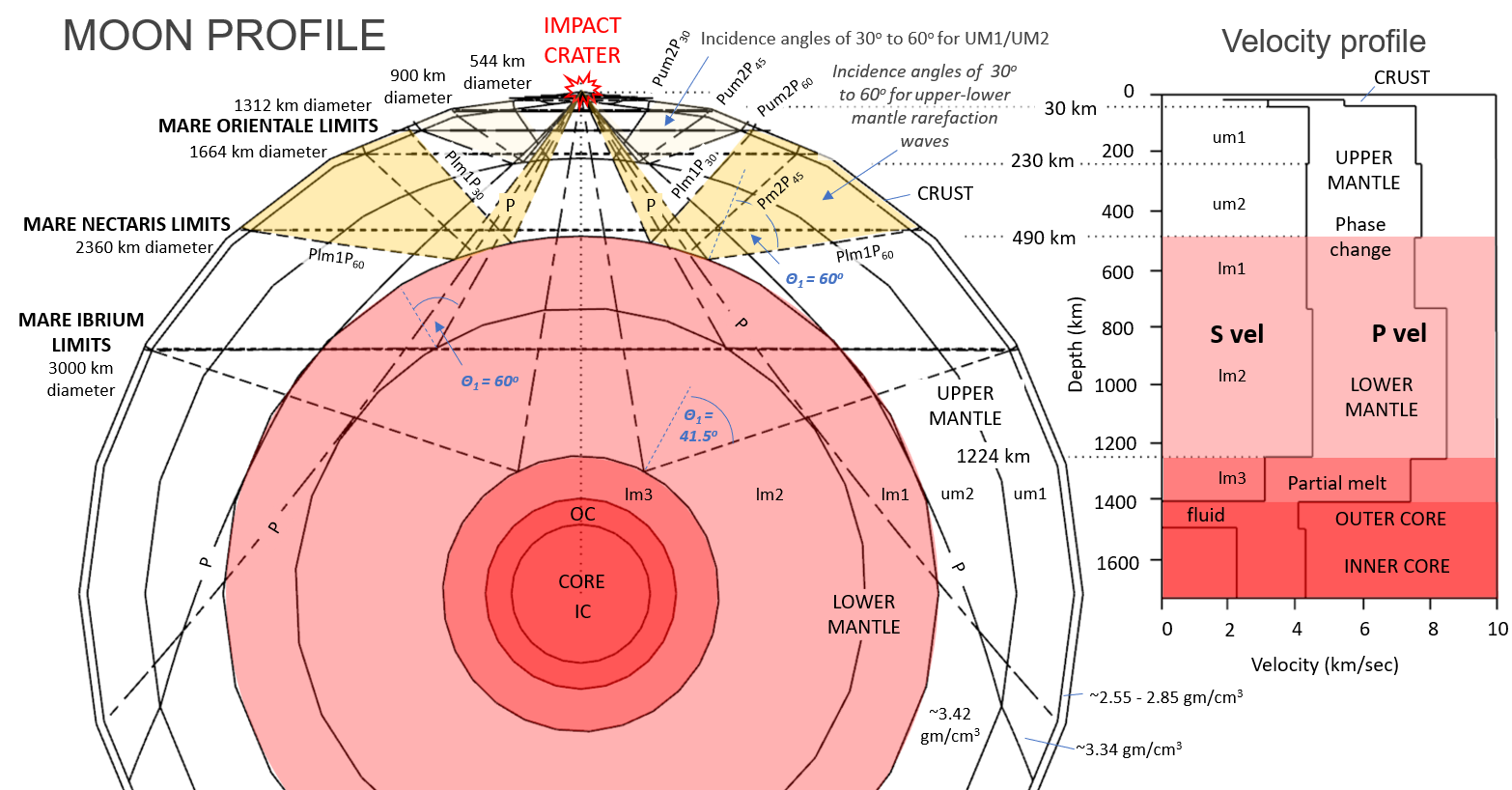 Figure 7. A Moon profile and aligned seismic-velocity profile adapted from Weber and others (2011) used to model interior phase boundaries. Mantle and crustal regions having energetic shock-wave rarefaction reflections are highlighted yellow. The outer rings of some impact basins correlate well with shock reflections of 60° arising from material-phase boundaries with inverted acoustic impedances like the upper- and lower-mantle boundary (fig. 8; Telford and others, 1976). Seismic-wave energy coefficients vs. wave-incidence angles for reflected and transmitted compression waves
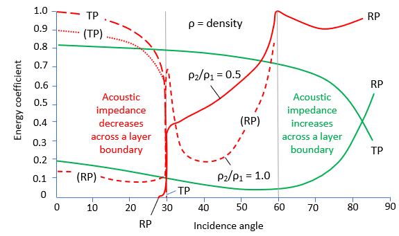 Figure
8.
Graph
adapted from Telford and others (1976, fig. 4.18) of compression-wave energy
coefficients versus incidence angles for partitioning compression-wave
energy at layer boundaries of contrasting densities. Most shock energy
is transmitted across layers having increased density contrasts at
incidence angles less than 60°. But most of the seismic
energy is reflected off all boundaries at high incidence angles above 80°.
The most
reflected energy is focused at a 60°
incidence angle for boundaries having decreasing densities and compression-wave
velocities (inverted acoustic-impedance contrast). Figure
8.
Graph
adapted from Telford and others (1976, fig. 4.18) of compression-wave energy
coefficients versus incidence angles for partitioning compression-wave
energy at layer boundaries of contrasting densities. Most shock energy
is transmitted across layers having increased density contrasts at
incidence angles less than 60°. But most of the seismic
energy is reflected off all boundaries at high incidence angles above 80°.
The most
reflected energy is focused at a 60°
incidence angle for boundaries having decreasing densities and compression-wave
velocities (inverted acoustic-impedance contrast).
Lunar seismic-compression-wave reflection geometry in the
upper mantle
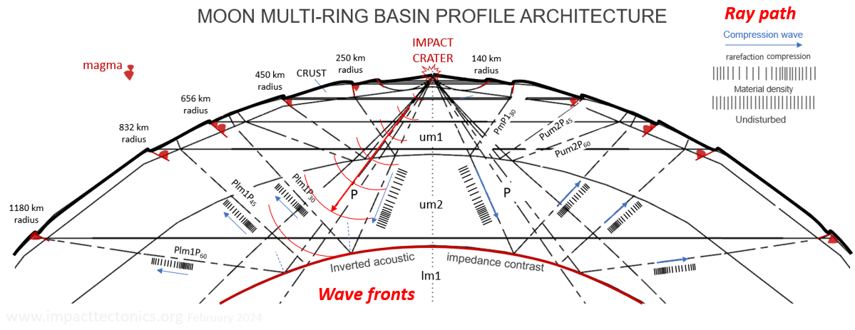 Figure 9. Compression-wave refraction and reflection paths for the Moon’s crust and upper mantle at 30°, 45°, and 60° incidence angles. P-wave refractions follow those of Wieczorek (2009). Note how head waves reflected off phase boundaries with negative impedance contrasts give rise to rarefaction waves that return to the surface with diminished energy but first-arrival tension that induces normal, brittle failure and localized upper-mantle melting along crustal faults. The South Pole - Aiken Basin (SPA) 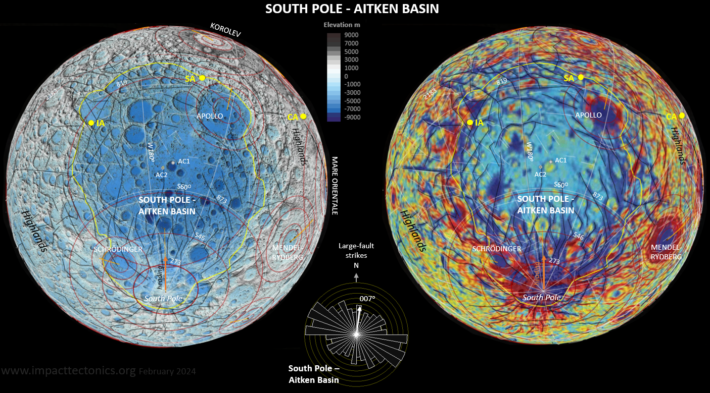 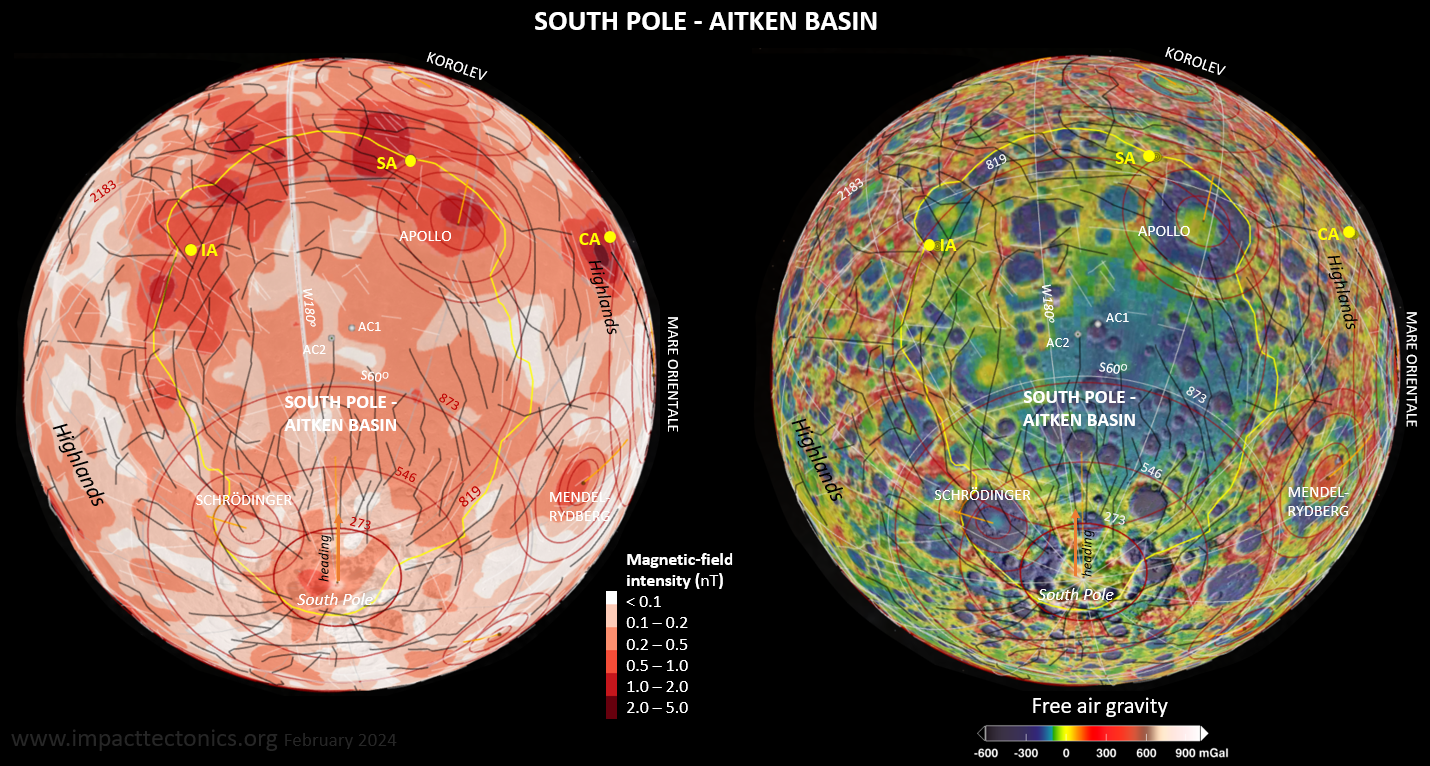 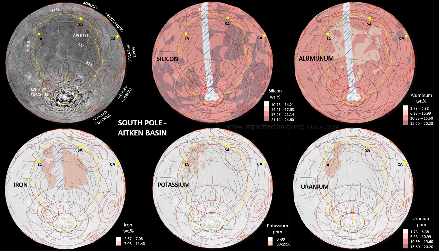 Figure
10.
The SPA basin portrayed in GE Pro using ten
geospatial themes. Top pair includes NASA LOLA DEM (left) and Bouguer
Gravity by Watters (right; 2022). Middle pair is SELENE magnetics (left)
and GRAIL free-air gravity (right). The bottom panel
includes a stock GE
Pro surface image and NASA LP spectroscopy for silicon, aluminum, iron (wt.
%) and potassium and uranium (ppm). The blue stippled area along
longitude W180° is a 5° data gap that is explained
in the text. CA - Mare Crisium antipode, IA - Mare Imbrium antipode, SA
- Mare Serenitatis antipode. AC1 - Aitken basin center of Hurwitz and Kring (2014). AC2 - Aitken basin 890-km radius center ring center. Figure
10.
The SPA basin portrayed in GE Pro using ten
geospatial themes. Top pair includes NASA LOLA DEM (left) and Bouguer
Gravity by Watters (right; 2022). Middle pair is SELENE magnetics (left)
and GRAIL free-air gravity (right). The bottom panel
includes a stock GE
Pro surface image and NASA LP spectroscopy for silicon, aluminum, iron (wt.
%) and potassium and uranium (ppm). The blue stippled area along
longitude W180° is a 5° data gap that is explained
in the text. CA - Mare Crisium antipode, IA - Mare Imbrium antipode, SA
- Mare Serenitatis antipode. AC1 - Aitken basin center of Hurwitz and Kring (2014). AC2 - Aitken basin 890-km radius center ring center.Maria Imbrium and Serenitatis 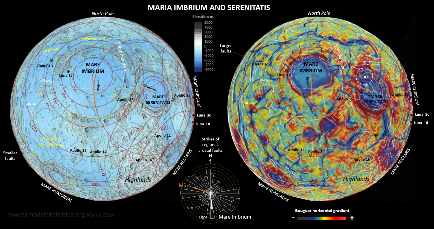 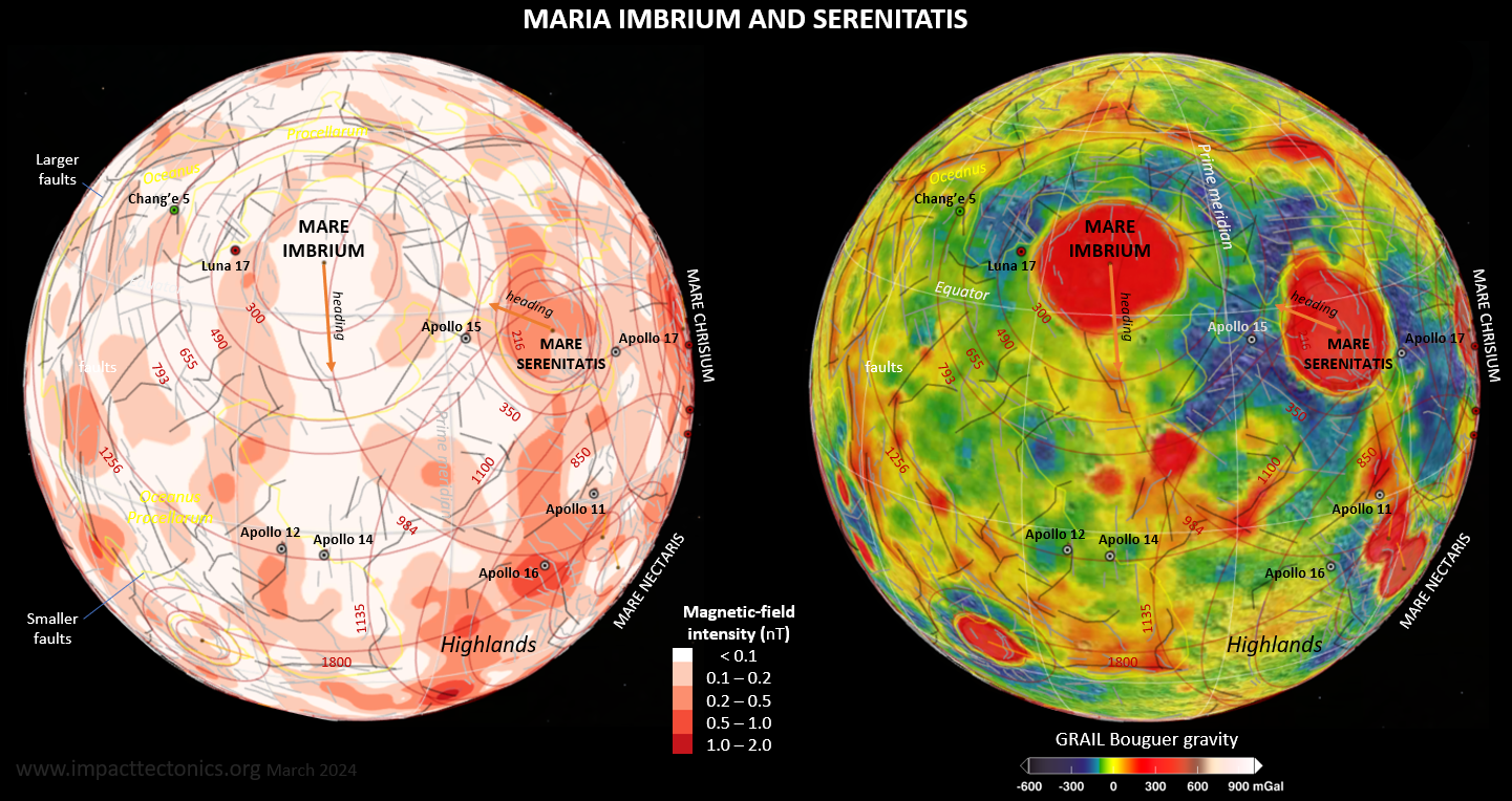 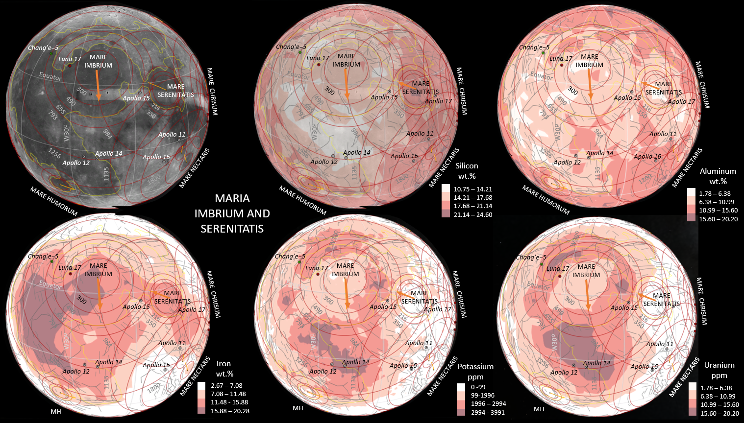 Figure
11. Maria Imbrium and Serenitatis
portrayed in GE Pro using ten
geospatial themes. Top pair includes NASA LOLA DEM (left) and Bouguer
Gravity by Watters (right; 2022). Middle pair is SELENE magnetics (left)
and GRAIL free-air gravity (right). The bottom panel includes a stock GE
Pro surface image and NASA LP spectroscopy for silicon, aluminum, iron (wt.
%) and potassium and uranium (ppm). Geosamples locations noted. Figure
11. Maria Imbrium and Serenitatis
portrayed in GE Pro using ten
geospatial themes. Top pair includes NASA LOLA DEM (left) and Bouguer
Gravity by Watters (right; 2022). Middle pair is SELENE magnetics (left)
and GRAIL free-air gravity (right). The bottom panel includes a stock GE
Pro surface image and NASA LP spectroscopy for silicon, aluminum, iron (wt.
%) and potassium and uranium (ppm). Geosamples locations noted.Mare Nectaris 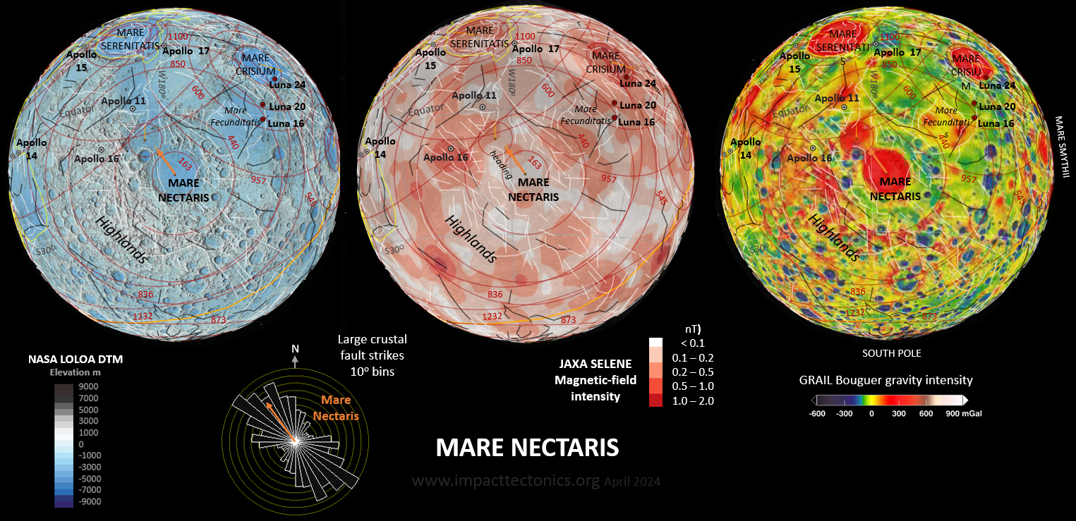 Figure
12.
A GE Pro portrait of the Mare Nectaris astrobleme
overlapping an earlier one using the NASA blue
steel DTM (left),
JAX SELENE magnetic-field intensity (middle), and GRAIL free-air gravity intensity
(right). This astrobleme displays axial splitting with a type,
double-shear fault response. It likely was of moderately high obliquity
and northwest heading. It marks the base of the Nectarian lunar period
before the late-heavy bombardment period. Ring radii marked in kilometers. Figure
12.
A GE Pro portrait of the Mare Nectaris astrobleme
overlapping an earlier one using the NASA blue
steel DTM (left),
JAX SELENE magnetic-field intensity (middle), and GRAIL free-air gravity intensity
(right). This astrobleme displays axial splitting with a type,
double-shear fault response. It likely was of moderately high obliquity
and northwest heading. It marks the base of the Nectarian lunar period
before the late-heavy bombardment period. Ring radii marked in kilometers.Mare Crisium 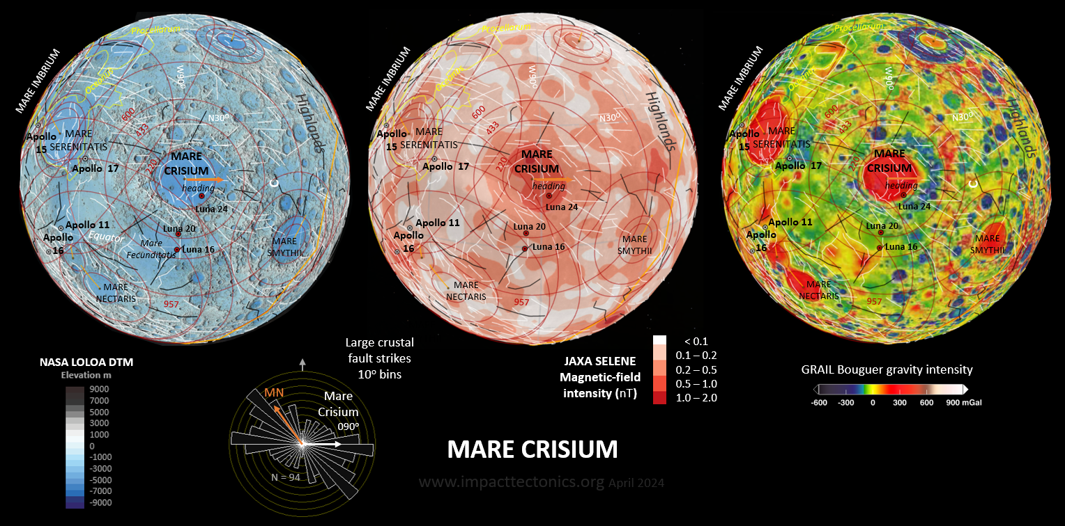 Figure
13.
A GE Pro portrait of the Mare
Crisium astrobleme using the NASA blue
steel DTM (left), JAX SELENE magnetic-field intensity (middle), and GRAIL free-air gravity intensity
(right). This
astrobleme also displays axial splitting and of moderately high
obliquity and eastward heading. Earlier faults from Mare Nectaris are
crosscut by Mare Crisium as seen in the circular histogram. Figure
13.
A GE Pro portrait of the Mare
Crisium astrobleme using the NASA blue
steel DTM (left), JAX SELENE magnetic-field intensity (middle), and GRAIL free-air gravity intensity
(right). This
astrobleme also displays axial splitting and of moderately high
obliquity and eastward heading. Earlier faults from Mare Nectaris are
crosscut by Mare Crisium as seen in the circular histogram.Mare Orientale 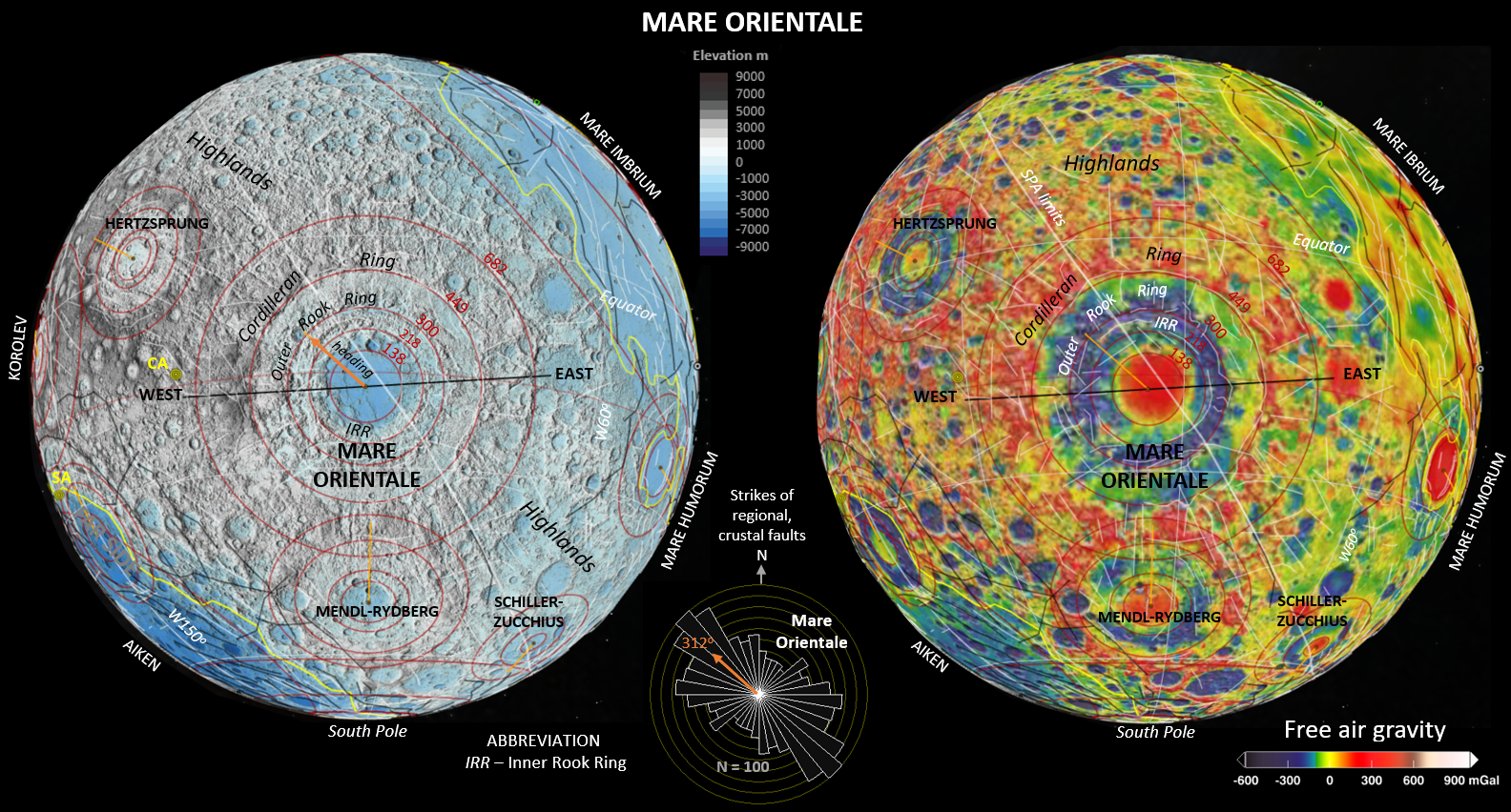 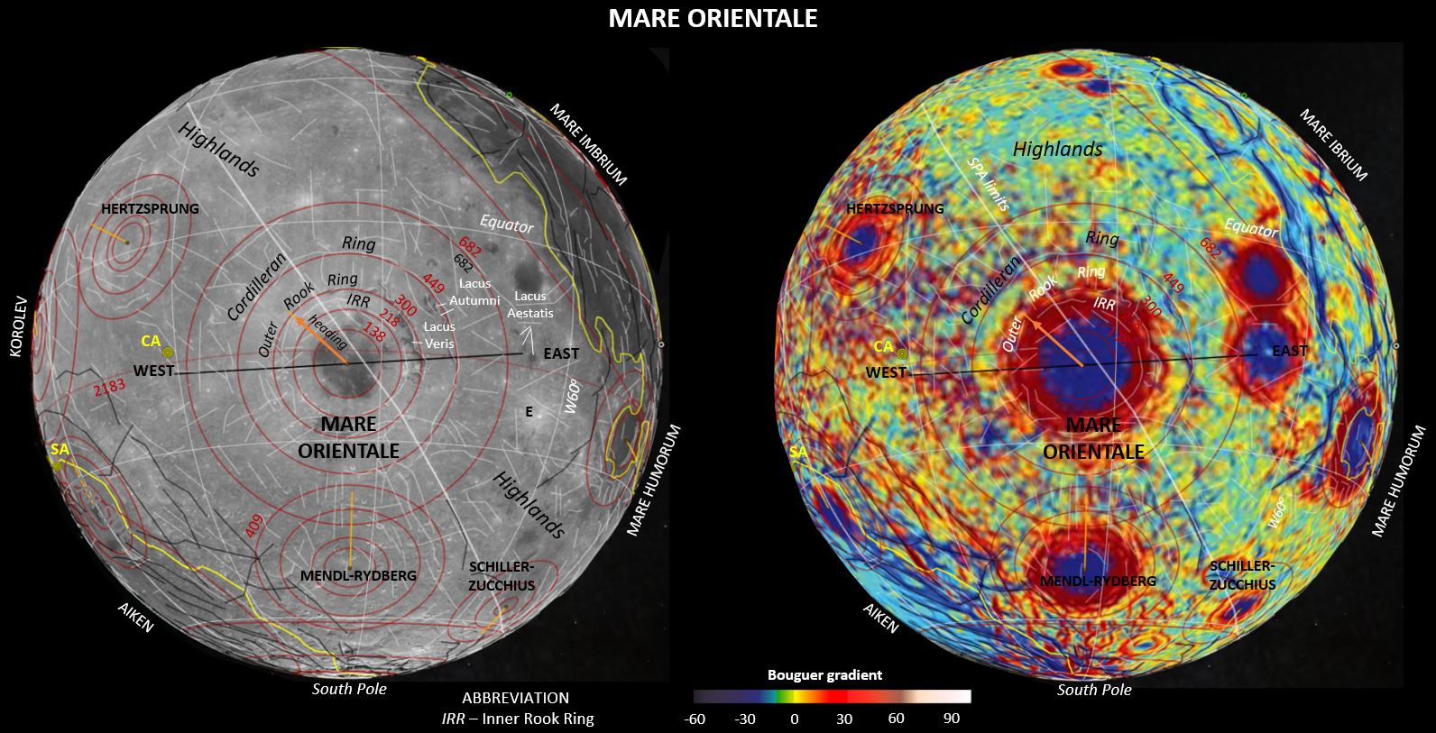 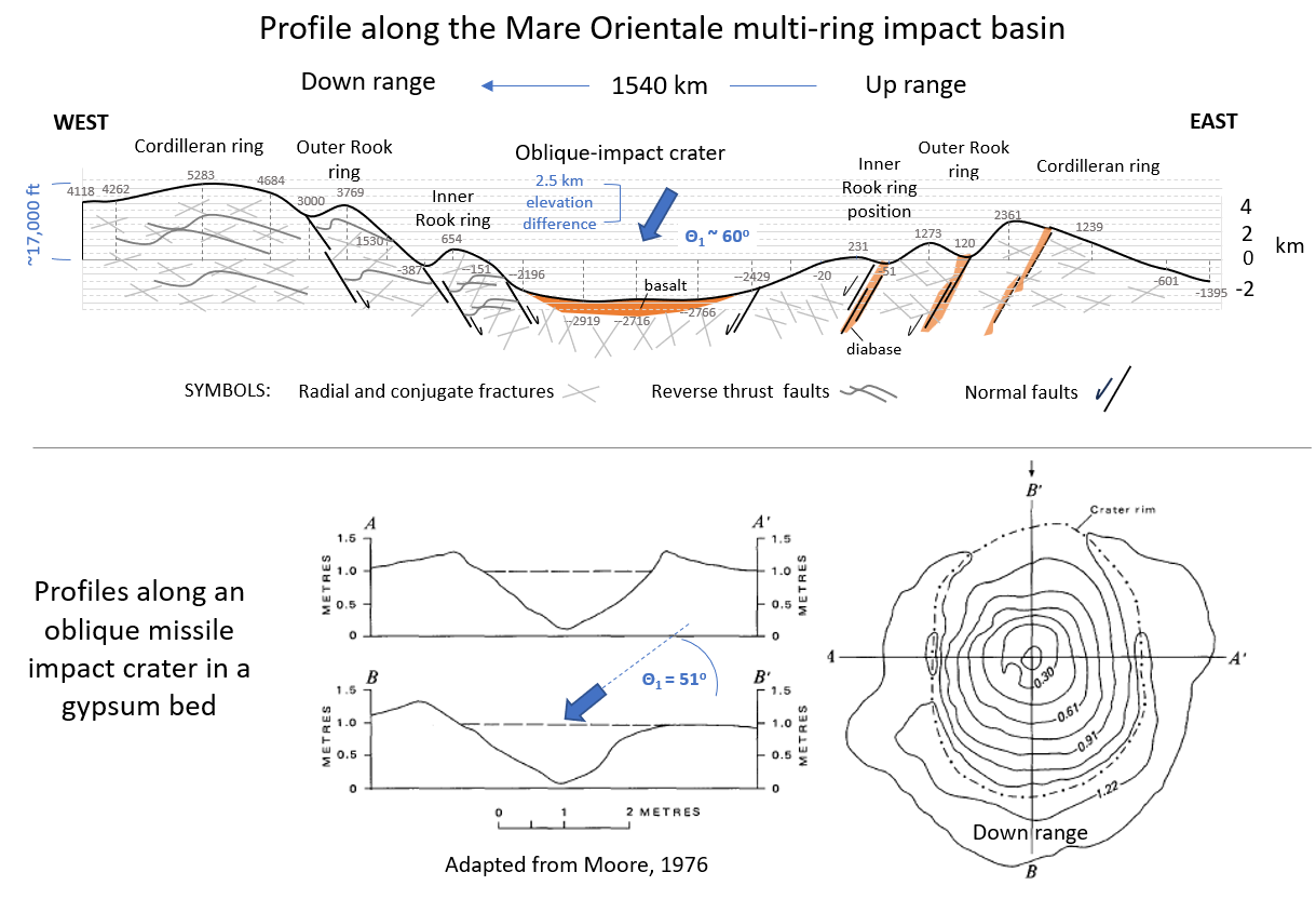 Figure
14.
Mare Orientale in GE Pro (top) and cross section (bottom). Top maps include
the NASA Blue Steel DTM (left) and the GRAIL free-air gravity themes
(right). above maps using GE Pro stock imagery (left) and the Watters (2012) Bouguer gravity theme (right). Bottom diagrams include an E-W cross
section of the Mare Orientale basin above diagrams of Moore (1976)
illustrating maps and profiles of craters formed by oblique missile
strikes. Figure
14.
Mare Orientale in GE Pro (top) and cross section (bottom). Top maps include
the NASA Blue Steel DTM (left) and the GRAIL free-air gravity themes
(right). above maps using GE Pro stock imagery (left) and the Watters (2012) Bouguer gravity theme (right). Bottom diagrams include an E-W cross
section of the Mare Orientale basin above diagrams of Moore (1976)
illustrating maps and profiles of craters formed by oblique missile
strikes.Lunar impact tectogenesis 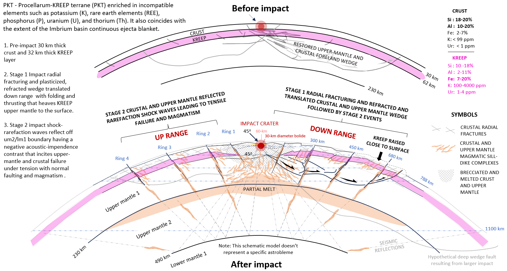 Figure 15. Profile diagrams of lunar, upper mantle and crustal ITFF strains, and a large igneous province stemming from impact tectogenesis that includes ring dikes intruded along concentric faults. A structural solution to having KREEP terrane registered spectroscopically on the lunar surface is to have deep-seated upper mantle and crustal faults bringing uppermost-mantle layers to the surface downrange of a large, oblique impact from rapid, reverse faulting and uplift stemming from focused, refracted shock energy. Cone, cup, and saucer reflection ITFF geometry 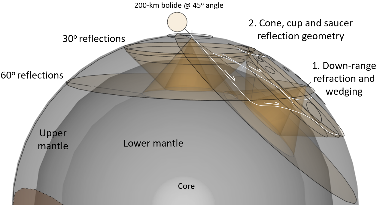 Figure 16. A SketchUp Pro 2022 CAD Moon model illustrating two overlapping sets of ITFF strain models comprising the South Pole -Aitken Basin astrobleme. This event involved a low- to moderate angle, very large, fragmented bolide with multiple projectiles having formed a vast strewn field including the Aiken basin where down-range upper-mantle wedging occurs from refracted, radial faulting that's overprinted by reflected rarefaction structures (fig. 17). SUP CAD model of the SPA and Maria Imbrium, Serenitatis, and Nectaris overlapping astroblemes occupying opposite hemispheres. 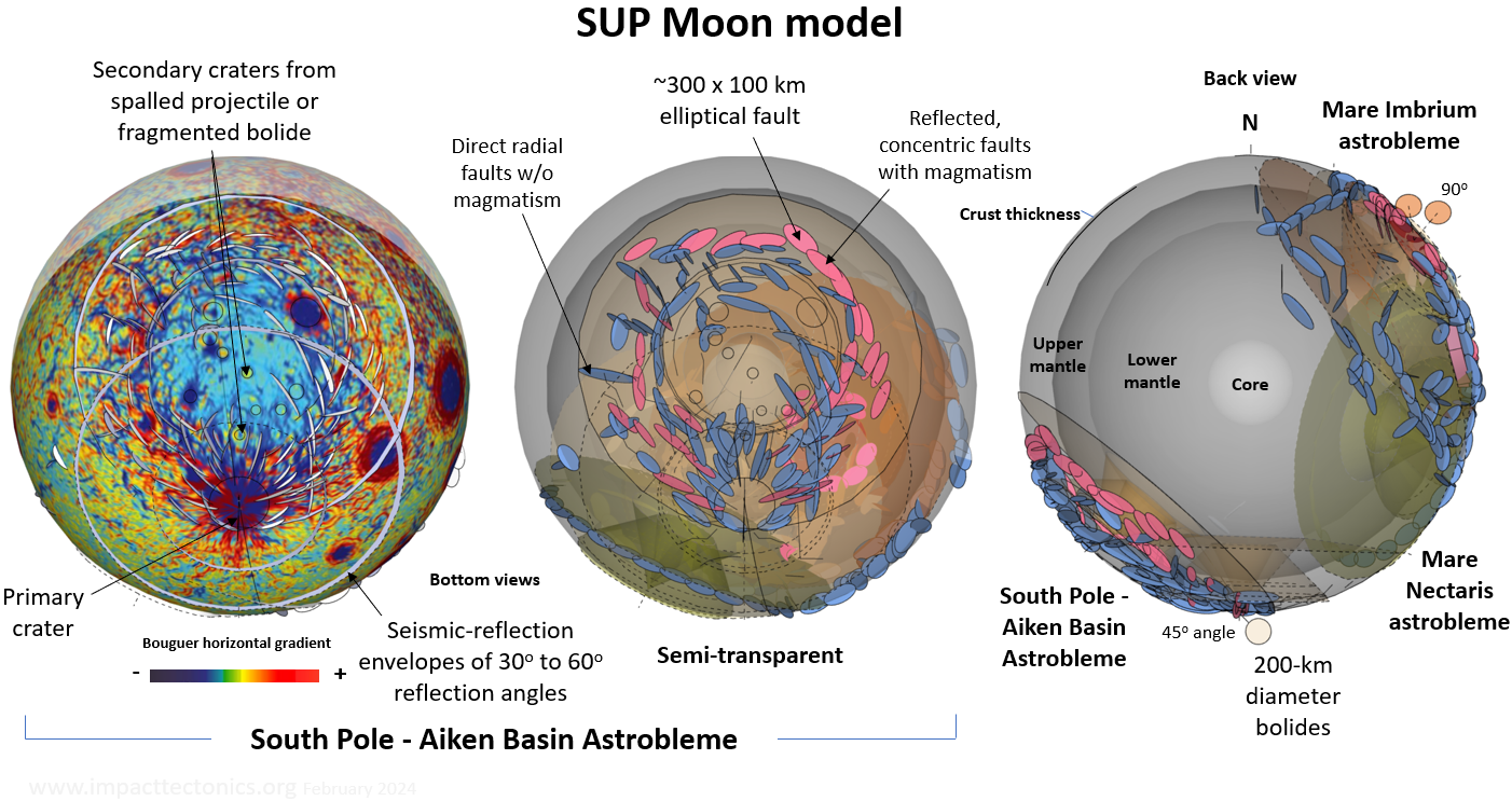 Figure 17. A SUPCAD model of the Moon includes structural details of the SPA and three other large astroblemes occupying the opposite hemisphere that include Maria Imbrium, Serenitatis, and Nectaris (fig. 18)The SPA is modeled with two impact centers, the more northerly having formed by spalling of the parent bolide forming the South Pole crater. Together they constitute an enormous impact strewn field. Low-intensity gravity anomalies peppering the Aitken basin downrange of the South Pole are likely secondary craters formed during this event. Three overlapping lunar astroblemes comprising Oceanus Procellarum 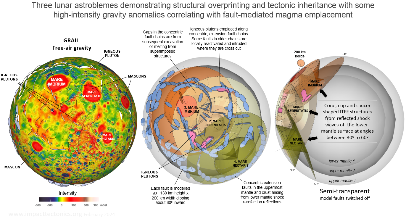 Figure 18. Maria Imbrium, Serenitatis, and Nectaris are three of the largest lunar astroblemes that overlap in close proximity on the Moon's nearside with ITFF strains that cut across and interfere with one another. A SU Pro model in semi-transparent mode is used to demonstrate the spatial alignment of mapped upper mantle and crustal faults caused by refracted and reflected shock-waves arising from the acoustic boundary between the upper and lower mantle. This surface has an inverted impendance contrast for compression waves that gave rise to rarefaction (pressure-release) waves that incited near-surface material failure under tension and upper-mantle magmatism from decompression melting. Igneous plutons intruded along the concentric, tensional faults correlate with localized high-intensity gravity flares. The shock-wave reflection geometry resembles cones and tea cups with saucers. The left two diagrams are overhead views of the overlapping astroblemes whereas the right diagram is a side view illustrating a cross-section perspective of the structural interference using the reflected 30o and 60o compression-wave models (fig. 16).
Lunar tidal locking
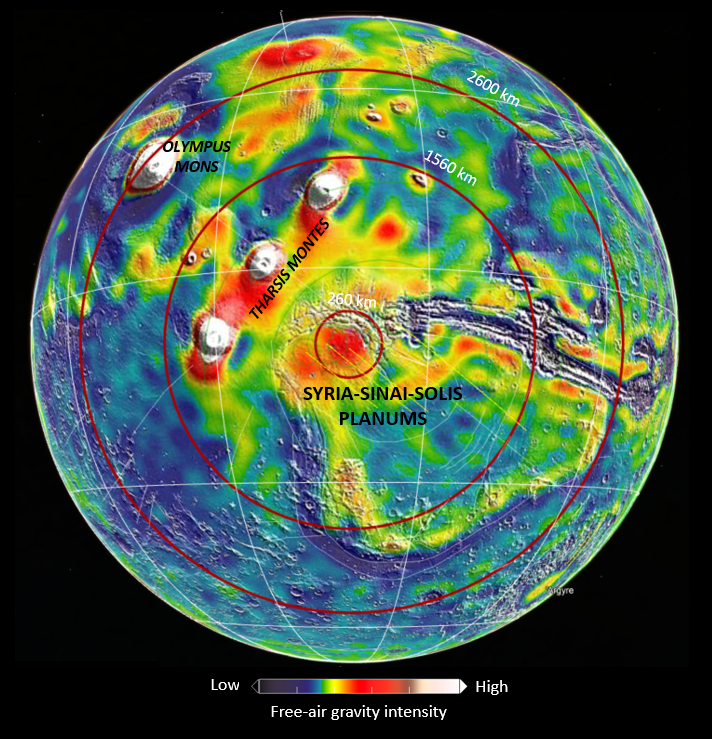
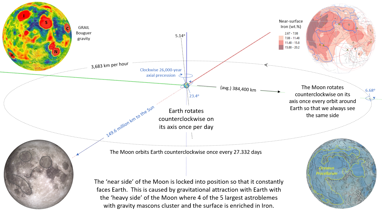 Figure 19. The Moon's heavy side has the densest concentration of mass (mascons) and always faces Earth. It's locked into orbit with Earth so that it spins once on its polar axis for each lunar orbit with its 'near side' always facing us. This is called tidal locking and explains why we only directly see half of the lunar surface. It also gives a spatial perspective on the powerful yet subtle gravitational forces operating over vast distances in space.A SUP CAD Mars model 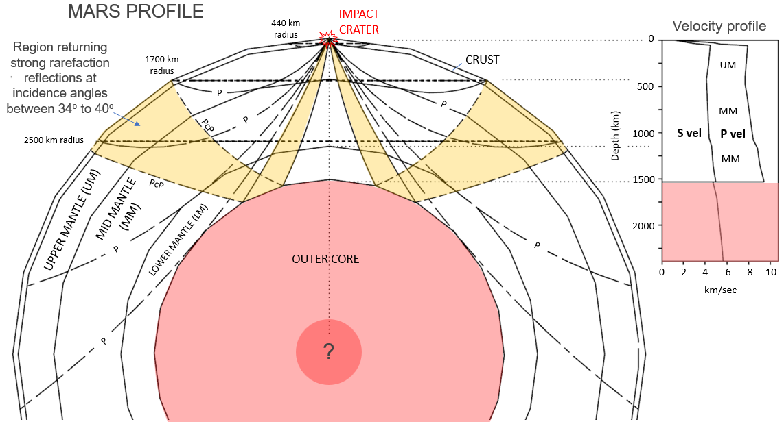 Figure 20. A SUP 2022 Mars model incorporating the seismological constraint on interior layering and the mantle regions where shock rarefaction reflections occur relative to a large impact crater. The major velocity inversion at about 1500 km depth at the boundary between the plastic mantle and liquid core is a major reflective surface. Reflections of 30° to 60° incidence angles are highlighted yellow and correspond spatially with the surface extents of Mars' largest astroblemes at about 2500 km radius. A satellite-derived gravity-intensity map of Mars centered on the Syria-Sinai-Solis Planums astrobleme
A SUP CAD Earth model
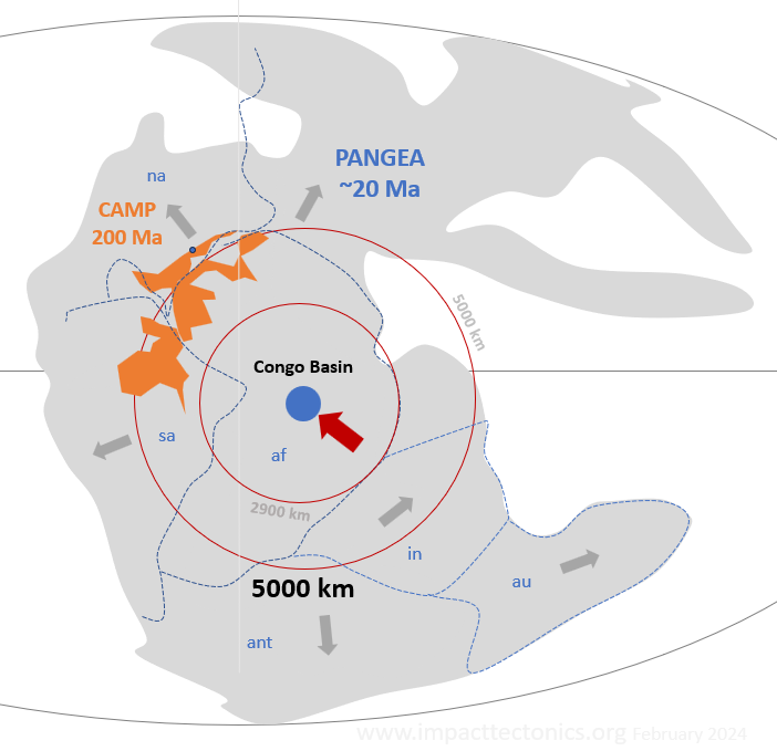
A satellite-derived gravity-intensity map showing the ringed structural nature of the suspected Congo basin astrobleme 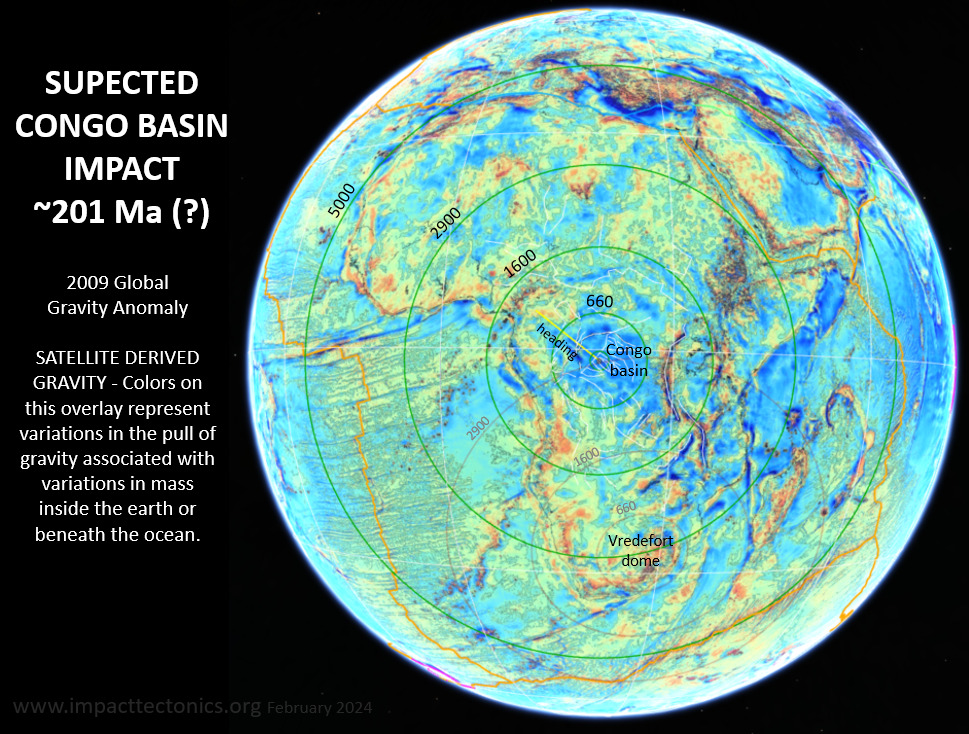 Figure 23.
A
satellite-derived, gravity-intensity theme for Earth made for GE Pro
portraying the crustal and upper-mantle stains centered on the Congo
basin, Africa. The 5000-km radius ring around the basin center
corresponds to the 60o rarefaction reflection off the
core-mantle boundary that directly aligns with the Triassic Newark rift
basins hosting the central Atlantic magmatic province (CAMP; fig. 23)
and the southern oceanic-spreading ridges framing Africa. This is also
when Pangaea
began splitting apart with India, North America, and
Australia drifting rapidly away. Figure 23.
A
satellite-derived, gravity-intensity theme for Earth made for GE Pro
portraying the crustal and upper-mantle stains centered on the Congo
basin, Africa. The 5000-km radius ring around the basin center
corresponds to the 60o rarefaction reflection off the
core-mantle boundary that directly aligns with the Triassic Newark rift
basins hosting the central Atlantic magmatic province (CAMP; fig. 23)
and the southern oceanic-spreading ridges framing Africa. This is also
when Pangaea
began splitting apart with India, North America, and
Australia drifting rapidly away. Stylized map reconstruction of Pangaea near the start of the Mesozoic Era showing how CAMP and continental rifting could have been spurred by a suspected bolide impact forming the Congo basin
|
I recently proposed punctuated tectonic equilibrium as an alternative tectonic theory to uniformitarianism after mapping impact-tectonic far-field (ITFF) crustal and upper-mantle strains in many astroblemes on Earth and Mars using global physiographic, gravity and magnetic geophysical themes, geographic information systems (GIS) and three-dimensional (3D) virtual globes (figs. 1 and 2; Herman, 2022). The ITTF strains are global tectonic components arising from impact tectogenesis; when catastrophic, large-bolide (asteroid or comet) impacts suddenly disrupt a terrestrial bodies' crust and upper mantle during episodes of projectile bombardment and mass accretion. However the manner in which shock stresses are absorbed and dispersed within the target body were underdeveloped then for shock strains stemming from reflected energy because of my initial focus on refracted shock strains after recognition of foreland ITFF compressive strains occurring down range from the Chesapeake (35.5 Ma) impact on the eastern seaboard of north America (fig. 1). This work therefore advances the geometry and structural effects of reflected shock energy as part of the finite strains on terrestrial bodies resulting from impact tectogenesis. The lunar surface and interior are first portrayed with 2D and 3D illustrations including seismological constraints that limit the geometric solutions for where reflected shock energy is focused to produce ITFF strains. The multi-ring astroblemes (impact structures) of the Moon are measured and placed into context with the interior layering to show how km-scale bolides impacting the lunar surface at hypervelocity speeds have produced numerous, large, multi-ring astroblemes having strain components stemming from both refracted and reflected shock energy. Two of the largest impact events, the South Pole - Aitken Basin and Mare Imbrium ones, have played significant roles in lunar geological evolution by generating regional melt bodies upon impact that included major phases of mineral-differentiation and fractionation resulting in the formation of the bright, silicon-rich, anorthosite highlands surrounding concentrations of dark, iron-rich mare (ma-aire); the high density, mafic admixture of impact-melted and reconstituted crust and upper mantle stemming from impact tectogenesis. The Moon lacks atmosphere and plate tectonics, so its surface geology stems from extraterrestrial bombardment and gives the clearest picture of ITFF strains manifest by targeted terrestrial bodies.
The seismological constraints from the lunar study are
then applied to profile illustrations of Mars and Earth that spatially constrain
regions around large terrestrial impact craters subject to focused shock
strains. This work is done using geographic information systems (GIS), the
Sketch Up (SU) Pro computer-aided 3D drafting system (CAD) and Google Earth Pro
(GE Pro). It is an exercise in analytical geometry rather than numerical
modeling, and structural insights are gained from applying empirical results
obtained from missile-impact tests (Moore, 1976), from both traditional (Telford
and others, 1976) and atomic-bomb seismology (Dienes and Fisher, 1961), and from
prior geological analyses of the lunar surface (Wilhem and others (1987) and
Watters and others (2022) among many others.
The concept of tectonic inheritance was also raised in
the aforementioned work because ITFF strain fields stemming from different
impacts overlap to form interfering surface structures with deep roots in
terrestrial bodies. An astrobleme imposes structural heterogeneity in a target
body that subsequently perturbs the shock responses made by subsequent impacts
with superimposed strain fields. Many ITFF structures also exhibit planar
geological symmetry with respect to impacts striking at oblique angles and
producing down-range crustal wedging and thickening opposed to up-range crustal
rifting where large tensile faults give rise to the sudden, concurrent
production of magma in deep reaches from dynamic decompression (figs. 1 to 3).
Mantle melting occurs along ITFF faults in both radial and concentric alignment
to craters that mediated magmatic ascent into the crust to form large igneous
provinces spurred by impact tectogenesis.
I begin by mapping and profiling the structural layering
and seismological nature of the Moon to gain a spatial perspective on how
refracted and reflected impact-shock energy produced its large impact basins and
ITFF multi-ring surface structures. Structural details for eighteen multi-ring
astroblemes are mapped using eleven geospatial themes to demonstrate how impact
tectogenesis produced the contrasting physiography of the bright lunar highlands
with the dark mare flooring deep, centralized impact basins that together
constitute the face of the Old Man of the Moon. The largest lunar impact basins
are portrayed as vast astroblemes where upper mantle and crustal layers have
been melted, plasticized, and brecciated around craters with crustal compaction
and thickening down range of oblique projectile strikes and tensional rifting up
range and circumferential to craters with the latter stemming from reflected
shock waves. LIP production apparently occurs in ways conforming to these two,
incremental, ITFF strains mechanisms with recognizable seismological behavior
and structural interference.
Figure 3 summarizes key geometric impact parameters used
to characterize interpreted bolide or missile trajectories including the
surrounding blast quadrants, angle of impact, and principal axis of compressive
stress. Oblique impacts display symmetry with respect to the plane of trajectory
as opposed to vertical impacts that are axis symmetric with more equally
distributed radial strains given a homogeneous target (Monteux and Arkani-Hamed,
2019). I also demonstrated both axis and plane-symmetric impact strain fields in
little glass spheres with a bench-top impact experiment that used a steel
projectile fired from an air gun into the glass balls at oblique impact angles
ranging between 35° and 85° (fig. 4; Herman, 2022). In the most energetic impact
test set at a very steep impact angle, a down-range structural tongue was
produced from absorbed shock energy that has a structural form resembling the
geometry of refracted elastodynamic compression (P) waves arising from
near-surface seismic sources in Earth’s crust (fig. 2). This experiment helped
constrain the geometry of down-range, foreland ITFF crustal wedging and
thickening seen at the regional scale for Earth and Martian astroblemes, but it
didn’t adequately explore the possibility of reflected impact-shock energy
contributing to the ITFF concentric faulting and crustal welting around large
impact craters. Outboard crustal arching, intra-plate seismic zones and crustal
drift of the North American tectonic plate (NAP) point to ITFF concentric
welting including active intra-cratonic seismogenic zones that define sub-plate
boundaries in North American lithosphere relative to the Chicxulub crater (fig.
1). The ITTF welting includes epierogenic arches and intervening troughs or
moats that together form low-amplitude lithospheric waveforms having amplitudes
on the order of few kilometers. These radial, curved structures are large
mountain ranges and sedimentary basins that likely formed by impact
tectogenesis. A good example of this is where southernmost Mexico and the
Central American isthmus arose from the seas along the 2900-km arch developed
around the Chesapeake impact (fig. 3). The focus here is on exploring how
grounded shock energy arising from large-bolide impacts is manifest in the upper
layers of the Moon, Earth, and Mars. I use computerized geological models that
are constrained by geophysical principles to illustrate how target bodies are
layered, and how those layers systematically dispel impact shock waves resulting
in ITFF regional strains including radial and concentric crustal faulting,
concentric lithospheric welting and large-igneous provinces (LIPS).
The bench-top impact experiments of Herman (2022) using
60 mm glass balls and a hardened steel projectile displayed systematic
variability of the strain-field areas with respect to impact obliquity, and the
typical development of conjugate, secondary, brittle structures bracketing the
crater that varied in their extent and density with respect to gentle (<30°),
intermediate (30° - 60°), and high (>60°) impact angles when measured from the
spherical surface (fig. 4). The geometry and area of each strain field varied
with impact angle such that the near-normal impact has a circular shape and
axial symmetry whereas those formed by moderate to shallow impact angles
developed planar symmetry across the plane of trajectory (figs. 3 and 4). The
moderate-angled impacts produced fan shaped strain fields, and impacts at the
shallowest angle having the largest faults flaring out in lateral sectors in a
direction normal to the impact headings (fig. 4). These forms are referenced
below to help interpret an astroblemes impact obliquity, but impact angles are
not tallied in table 1 owing to the high levels of uncertainty in their
interpretations. More impact testing into spherical surfaces is necessary in
order to derive statistically valid reference models more certain ones. Large
crustal fault striking in conjugate arrangement bracketing an impact strewn
field were also noted in the structural analysis of thirteen Martian astroblemes
using remote sensing (Herman, 2022). The most notable aspect of these impact
experiments and mapping exercises was the production of a down-range, fractured
wedge from refracted shock energy that was focused downward within the target
along the line of impact momentum (fig. 2). The structural tongue descends into
the foreland blast sector where the focused energy was refracted back to the
surface almost one-quarter of the surface span away from the crater. The
downrange wedging stems from uniaxial compression of the targeted media and
opposes the up-range sector where tensile fracturing occurs after the crust is
first compressed, then stretched behind the down-range sector like that seen on
Mars for the Syria-Sinai-Solis Planums astrobleme and up-range volcanism.
Sequential impact-generated shock events on a planetary
surface gradually hardens its exterior from repeated bombardment producing
overlapping, far-field strains exhibiting tectonic inheritance (Herman, 2022).
In other words, pre-existing geological heterogeneity of a terrestrial body will
influence the seismological expression of absorbed energy and hence structural
expression of successive, overlapping strain fields. But the ITFF strains
occurring as regional, large-scale, epierogenic welts are poorly understand and
their geodynamic mechanisms ill defined. I therefore attempt to address these
aspects below by first mapping and parameterizing eighteen multi-ting lunar
impact basins, and then using a 3D Moon model to portray seismologically
constrained, geometric solutions for the shock strains stemming from km-scale
bolide impacts resulting in multi-ring terrestrial astroblemes (fig. 5). Impact
tectogenesis must also include the geological processes and sets of secondary
structures leading to the formation of the lunar highlands where thickened
crustal regions having elevated gravity intensities likely reflecting the
spurred emplacement of basic- to granitic plutons along secondary faults and
mineral veins lying beneath impact-generated regolith and distal ejecta blankets
that radiate outward beyond the crater for hundreds to thousands of kilometers
distance (fig. 6 and Willhelms and others, 1986). Widespread epierogenic, or the
pronounced vertical tectonic shifts that have been noted since the advent of
geology as a science, are placed into geospatial perspective below with the
natural, but extraterrestrial-born, impact-tectonic agents of bolide bombardment
and accretion that are integral agents of solar system evolution.
With respect to the Moon, much of its geologic history is gained by studying the distribution and structural expression of large, multi-ring astroblemes across its surface and from geological analyses of about one-third ton of surface samples and core collected on the near side by the U.S.A, Russia, and Chinas' manned and unmanned missions (figs. 5 and 6, and table 1). According to Wilhelms and others (1987) impacts began to leave a visible record about 4.2 billion years ago (Ga), after the crust and mantle had differentiated and the crust had solidified. At least 30 basins and 100 times that many craters larger than 30 km in diameter were formed before a massive impact created the Nectaris basin about 3.92 Ga. Impacts continued during the ensuing Nectarian Period at a lesser rate, whereas volcanism left more traces than during pre-Nectarian time. The latest basin-forming impacts created the giant and still-conspicuous Imbrium and Orientale basins during the Early Imbrian Epoch, between 3.85 Ga and 3.80 Ga. The rate of crater-forming impacts continued to decline during the Imbrian Period. Beginning in the Late Imbrian Epoch, mare-basalt flows remained exposed because they were no longer obscured by many large impacts. The Eratosthenian Period (3.2-1.1 Ga) and the Copernican Period (1.1 Ga to present) were times of lesser volcanism and a still lower, probably constant impact rate. Copernican impacts created craters whose surfaces have remained brighter and topographically crisper than those of the more ancient lunar features. But so far, no direct sampling has occurred on the far side.
As impact craters increase in size, they become
increasingly complex and change from having central peaks or groups of peaks to
having central depressions surrounded by two or more mountainous rings (Hartmann
and Kuiper, 1962). This transition occurs for structures exceeding about 180 to
300 kilometers in diameter with the latter regarded as impact basins. More than
thirty multi-ring astroblemes are identified on the Moon as these structures
shape the lunar surface (Willhem and others, 1987; Fasset and others, 2012;
Tartèse and others, 2019; among many others). Eighteen of the largest and most
apparent multi-ring impact structures are mapped in figure 6 with the
corresponding ring radii and interpreted heading parameters recorded in table 1.
Hartmann and Wood (1971) provide a thorough review and
synthesis of geological thought surrounding multi-ring impact basins of the Moon
during the first decade of lunar exploration. Ideas for ring genesis ranged from
frozen crustal tsunamis to collapse faulting from propagating standing waves,
but they end their summary with the statement “stresses will be set up in the
Moon by the violent dissipation of energy during basin formation; all authors
agree that these stresses are likely to produce a series of concentric ring
fractures surrounding the basin, through the detailed theoretical models
differ.” A recurring aspect of this early work is the recognition of both
concentric and radial fault systems, the former of which has been characterized
as having a √2 ratio for inter-ring spacing (Hartmann and Wood, 1972). This is
predicated on the assumption that circular plates sagging into an underlying
fluid medium will fracture at distances near a √2 radius values based on the
theoretical and experimental work of Lacke and Onat (1962).
The Moon lacks plate tectonics but has a long history of
impact tectogenesis (fig. 5). It was likely born from an impact of proto-Earth
by a planetesimal about 4.5 billion years ago and its evolution since then
includes continuous meteorite bombardment that added mass to its body (Hartman
and Davis, 1975). Vast surface regions have been pulverized and melted from the
heat and energy absorbed from the largest impacts. Upon the initial hardening
and density stratification of its shell from an early, lunar magma ocean (LMO),
the Moon was subsequently pounded by large projectiles during the formative
stages of the solar system as the planets and their moons were settling into
place. A hypothetical, late-heavy bombardment (LHB) phase early in the lunar
chronology depicted in figure 5 from about 3.7 to 3.9 Ga is proposed to have
been spurred by the orbital adjustments of the four largest planets that
destabilized near-Earth asteroids resulting in a period of path clearing and
heavy bombardment that apparently focused on the near side for the Moon with
probable, coeval periods of impact tectogenesis on Earth and Mars (Gomes and
others, 2005). But as Harrison and others (2018) and Boehnke and Harrison (2016)
have pointed out, the most widely used evidence to support the LHB hypothesis
yields unreliable impact histories but does not preclude the existence of such
events.
Lunar multi-ringed astroblemes were instrumental in the
development of Melosh and McKinnon’s’ (1978) ring tectonic theory that explains
how large, concentric fault scarps develop around large impact craters from the
transient collapse of a crater rim inwards and downwards from gravitational
adjustments toward the crater center shortly after impact. The structural
process involves a rigid, but weakened crust and lithosphere sitting atop fluid
or ductile substrate that allows mantle flow from beneath to accommodate rigid
fault slip and block rotations in response to gravitational instabilities. This
is the only theory available at this time to account for the formation of ringed
basins, and many numerical simulations have been run to test this theory under a
wide range of conditions using variable impactor size, crustal thickness, and
near-surface thermal gradients that reproduce similar results with empirical
observations (Potter, 2015). But by their own admission they have not been able
to reproduce model results that consistently agree with observed ring-spacing
geometry using these methods. Currently, the computational time and fidelity of
the numerical simulations can only be tested for impacts occurring normal to the
surface and in two-dimensions. Three dimensional simulations including variable
impact obliquity have not been attained. But my fundamental concern with
ring-tectonic theory is the assumption of having a fluid layer below the crust
to allow rapid creep of the mantle material that accommodate the differential
movement of overlying solid fault blocks. Perhaps melting of the upper mantle
immediately upon impact temporally provide the fluid substrate needed to
accommodate crustal extension, but according to the lunar seismic data, there is
no fluid substrate beneath the Moon’s crust showing seismic shear-wave
dampening. The first apparent, internal seismological boundary in the upper
mantle having reduced S-wave velocities occur at about 230 km depth but
accompany increased P-wave velocities. This upper-mantle acoustic boundary
therefore likely stems from mineral-phase transitions involving crystalline
anisotropy that retard S-wave transmissions but are denser with more rapid
P-wave velocities. The first noticeable acoustic-layering contrast in the upper
mantle occurs at a depth of about 490 km and separates the upper and lower parts
of the mantle with an inverted impedance contrasts for compression waves (figs.
7 to 9).
Very large impacts also produce widespread ITFF strains in the form of radial and concentric faulting and folding with the consequential development of large igneous provinces (LIPs) fed by deep-penetrating faults that mediate the ascent and dispersal of mantle-derived basic lava covering large areas like surface areas like Oceanus Procellarum (fig. 6). Material ejected from impact basins has also been distributed over vast surface reaches and provide useful markers in analyzing a meteorite's horizontal heading and the geologic history of the Moon (Wilhelm and others, 1987; among others). For example, if a crater or other structure is superimposed, or formed on top of such ejecta, then the crater is younger than the impact basin. On the other hand, if a feature is partially buried by the ejecta blanket, the feature must be older than the impact basin. By analyzing stratigraphic superposition and cross-cutting structures across the Moon, it is possible to derive a relative overview of the lunar geological history that is partly constrained with absolute radiometric dating of collected surface samples of mostly loose material, regolith, and boulder fragments (figs. 5 and 6).
We know from the NASA Grail
mission that the lunar crust ranges in thickness from near zero from excavation
around cratered areas to over 60 km thick in the lunar highlands (Miljkovic,
2018). Planetary geologists generally use the starting assumption that the
excavation depth of a cratering event is about 10% of the excavated diameter (Melosh,
1989; Melosh and Ivanov, 1999). If we use a average crustal thickness of 30 km
for the Moon, then upper-mantle excavation and mixing occurs for astroblemes
with inner rings exceeding 300 km diameter. As detailed below, only the five
largest lunar astroblemes exceed this size. Very large, deep craters are floored
by mare, melted crust + upper-mantle material. Mare is ponded within the
cratered, central regions of large impact basins (fig 6). This also happens
sometimes on Earth (French, 2004). Mascons are circular, high-intensity gravity
anomalies where ponded mare is concentrated (Phillips and others, 1997). Sampled
lunar basalts have an average crustal density of ~ 3.3 gm/cm3, whereas the bulk
Moon crust is ~ 2.95 gm/cm3 owing to the abundant plagioclase feldspar in
anorthosite-rich crust of the lunar highlands that is comparatively light and
thick with respect to mare.
Global geophysical themes have
proven very useful in demonstrating ITFF strains occurring in radial alignment
around large craters as part of planetary astroblemes, or ‘star wounds’ (Dietz,
1962; Buthman 2022; Herman 2022). Eighteen large impact basins displaying
multi-ring architecture are listed in table 1 from the largest to smallest and
mapped in figure 6 using eleven different geospatial themes. The interpretations
use publicly available geospatial data from the United States of America (USA)
National Aeronautics and Space and Administration (NASA) and Japan’s National
Space Development Agency (NSDA). Each impact basin has at least three rings with
the second largest (Mare Imbrium) having six, and the largest (South Pole -
Aitken Basins) having two sets of rings and ITFF strains that span a global
hemisphere (fig. 6). Astrobleme structural analysis relied upon the detailed
topographic, gravity, and seismic-velocity themes to characterize ITFF strains
and obtain model dimensions for the Moon, Earth, and Mars. The largest lunar
astroblemes contain the curvilinear mountains chains surrounding impact basins
as core components of defined ITFF strain envelopes that cover between 0.5% to
over 43% of the globe (fig. 6 and table 1).
The computer methods used to map the astroblemes and
conduct a spatial comparison between mapped lithosphere strains and expected
seismological responses includes Google Earth Pro (GE Pro), QGIS desktop
software (ver. 3.16.14), and the SketchUp (SU) Pro 2020 computer-aided drafting
system (CAD). GE Pro and QGIS provide compatible file formats for exchanging
data files and exporting the results into SU Pro for 3D modeling of the Moon,
Earth, and Mars. The SU Pro extension spirix_textured_sphere by J. Hamilton
(ver. 05.29.2016) was downloaded from the Spirix website and used to wrap
geographic maps around virtual 3D Earth and Moon globes. Circular histogram
analyses were conducted on sets of mapped radial faults within the mapped limits
of the largest astroblemes using the QGIS Line Direction Histogram plugin by H.
Tveite (ver. 3.1.1, 2020). The Contour QGIS plugin by C. Crook and L. Roubeyrie
(ver. 2.0.12, 2023) was used to generate maps of magnetic-field intensity and
near-surface crustal, elemental abundances derived from reduced spectroscopy
data obtained by NASA’s Lunar Prospector (LP) and website (Feldman and others,
accessed 2023). The GE Pro plugin Range Rings for Google Earth by T. Davis and
R. Turner (ver. 2023) was used to generate polyline rings of specified radius
around impact points lying near the center of large craters. Bolide headings and
large faults seen in the various geospatial themes were manually digitized in
both GE Pro and QGIS using geographic spatial coordinates. The SU Pro global
models use kilometer distance units.
NASA’s Lunar Reconnaissance Orbiter (LRO) Wide Angle
Camera and the Lunar Orbiter Laser Altimeter (LOLA) instrument have enabled the
accurate portrayal of the shape of the entire moon at high resolution (www.lunar.gsfc.nasa.gov/lola/index.html).
The LRO was launched and began operations in 1997 that continue today.
Topographic elevations were surveyed to about one-meter accuracy for each
~118-meter pixel in the global digital terrain model (DTM; Mazarico and others,
2013).
The Gravity Recovery and Interior Laboratory (GRAIL) was
another NASA mission run in 2011 and 2012 to obtain high-quality gravitational
field mapping of the Moon to help determine its interior structure. The GRAIL
mission produced high-resolution maps of the Moon’s gravitational field,
including global, free-air and Bouguer gravitational-intensity anomalies (figs.
6C and 6D; www.svs.gsfc.nasa.gov/4014). Bouguer anomalies are derived from the
free-air data by correcting for gravitational effects of variable topography.
The GRAIL mission flew twin spacecraft (Ebb and Flow) in tandem around the Moon
to map variations in the lunar gravitational field. At the end of the mission,
the probes were purposely crashed on the Moon (www.solarsystem.nasa.gov/missions/grail/in-depth/).
A second Bouguer gravity map used in this study is from
Watters (2022) that is the basis for mapping very-large fault systems that
penetrate the crust into the upper mantle (fig. 6E). This map uses a color
scheme that highlights gravity gradients rather than gravity intensities as for
the GRAIL themes. The Watter's map seems to emphasize features that have rapid
field-intensity changes over small distances like where large crustal fault
zones occur that are brecciated, mylonitized, and can locally penetrate to
upper-mantle reaches to mediate the ascent of magma (figs. 12, 15, and ). The
best examples of this are seen is the eastern margin of the South Pole - Aiken
(SPA) Basin astrobleme where braided fault segments stream dark blue through the
eastern, lateral reaches to partly bracket this enormous impact basin (fig. 10).
These earliest anomalies are cross cut by younger, high-intensity anomalies
that are concentric to impact craters and likely highlight impact-generated
igneous dikes that arose from the upper mantle or were generated within the
crust by decompression melting.
Global magnetometer data for the
Moon were obtained by Japan’s SELENE probe that are available to the public from
Japan’s Aerospace Exploration Agency (JAXA) in support of scientific and
educational purposes (fig. 6F; www.darts.isas.jaxa.jp/planet/pdap/selene/).
Japan’s NSDA SELENE probe was launched in 2007 and orbited the Moon collecting
geospatial data until 2009 when it was directed to impact the surface. The
magnetometer data were downloaded as tabular data with gridded, 1° data points
with the total magnetic field-intensity (F) values measured at 100 km elevation.
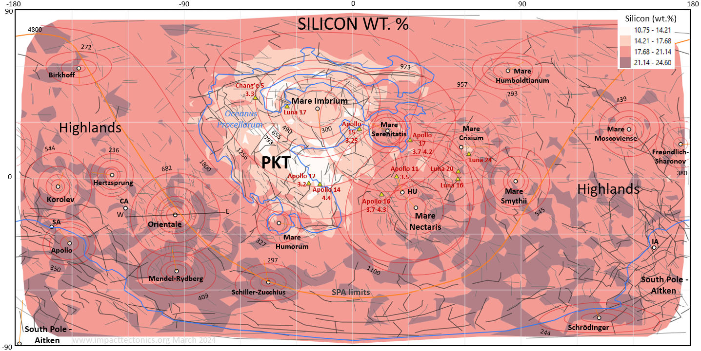
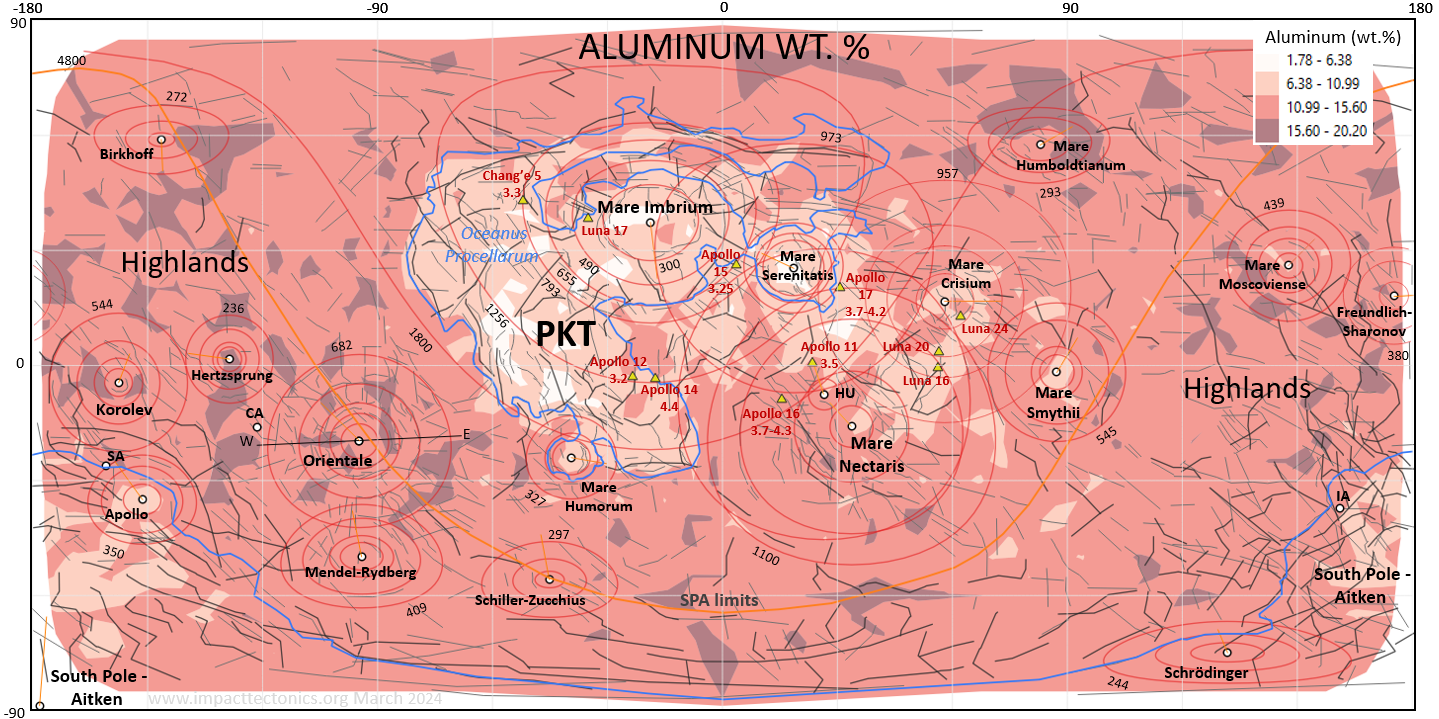
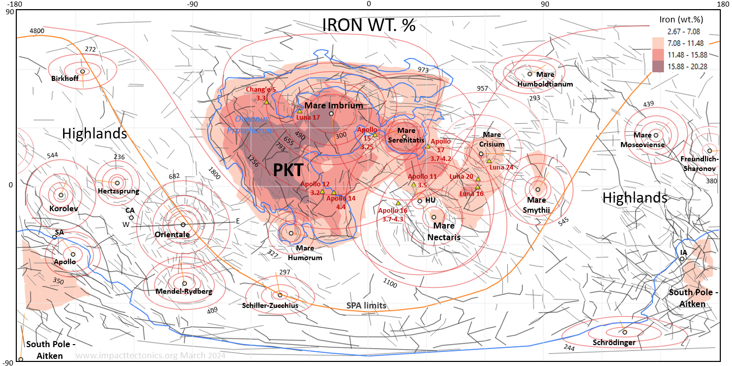
Spectroscopic sensing of the Moon’s surface by NASA’s
Lunar Prospector (LP) returned major and trace-element abundances in the upper
30 centimeters of ground surface (Feldman and others, accessed 2023). Geospatial
variability of elemental concentrations in large impact basins like the Aitken
basin and Oceanus Procellarum have been tied to depths of impact excavation and
the generation of melt bodies and flood basalts originating from the upper
mantle (Hurwitz and Kring, 2014; Uemoto and others, 2017; Zhu and others, 2019).
Spectrographic data are free from NASA as gridded ASCII text files formatted
with either 1o or 5° geographic cells with center points tagged with either
elemental bulk-weight percentage (wt. %) values or parts-per-million (ppm)
concentration units for aluminum (Al), silicon (Si), Iron (Fe), potassium (P),
thorium (Th) and uranium (U). Geographic maps of the various elemental
abundances were generated for each point theme by contouring the set of values
using three to five ranges of values, or quantiles, to colorize the map and
thereby allow a geospatial assessment of the elemental abundances for the major
impact basins (figs. 6G to 6L). Each geographic map was also added into a GE Pro
project as an image overlay further assess spatial comparisons using a virtual
globe (figs. 10 and 11). However, it is noted that using data recorded at cell
centers leaves small data gaps of either 1° or 5° along the frame of the
geographic boundaries. These data gaps are particularly noticeable along
longitude -180° when viewed using GE Pro (figs. 6 and 10).
A discussion of the elemental
distributions with respect to the larger impact basins is developed below when
focusing further on the structural and geophysical aspects of ITFF strains for
the six-largest astroblemes (figs. 10 to 14). The locations, sizes and
structural aspects for each of the eighteen multi-ring astroblemes therefore
relied upon visual inspection of observed surface features gleaned from
geophysical anomalies as visualized using geographic maps that are also used as
image overlays in the GE Pro virtual globe. Ring spacing noted in table 1 is
calculated and compared with the aforementioned √2 factor, and the interpreted
headings for the set of bolides are statistically analyzed using a circular
histogram that is compared to interpreted bolide headings derived for Mars (fig.
6M; Herman, 2022). The six largest multi-ring impact basins are further analyzed
using the NASA and JAXA geospatial data in GE Pro and the mapped dimensions of
the basin rings added to a SUP Moon model that incorporates seismological
constraints on the manner in which the Moon's interior layering will reflect
shock energy (figs. 7). A spatial comparison is then conducted on where
reflected shock energy would be focused in concentric alignment around large
craters using a CAD Moon model. This is used to highlight outlying regions
around large craters where large crustal faults are mapped based on global
topographic and gravity maps. Such faults radiate outward from craters with
steep dips and in many places correlate spatially with high-intensity gravity
anomalies likely stemming from basic, high-density upper-mantle melts (~3.34 gm/cm3 pervading
lower-density anorthosite crust (~2.55 - 2.85 gm/cm3; fig. 7).
The astrobleme rings were mapped in hierarchical order
and recorded in table 1 with the innermost ring designated 1 and outlying rings
noted as 2 through 6. The inner rings either coincide with the crater rim
approximated by the first set of topographic fault scarps forming the central
depressions, or the limits of gravity mascons for most of the astroblemes (fig.
6 and table 1). Only the SPA basin and the Birkhoff (table 1, no. 9) and Korolev
(table 1, no. 16) astroblemes lack central, high-intensity gravity anomalies
exceeding 300 mGal, although the latter two have relatively high-intensity
gravity anomalies on the order of 100-200 mGal (fig. 6C and 6D). The innermost
ring of most basins is mapped along the edge of the central, negative gravity
anomaly (fig. 6C). The outer basin rings (2 through 6) are drawn along visible
fault scarps or near the limits of concentric, gravitational-intensity
anomalies, although fault scarps are not perfectly concentric to craters and
form to varying degrees of density and elevations around craters owing to the
variance of many impact-related physical factors. For example, there is good
evidence that the Mare Orientale impact was at a moderate- to high angle (> 60°)
impact from a projectile heading westward owing to having a nearly continuous
set of outer rings and cordilleran uplift in a sector downrange of the crater
like that seen in missile-test studies (fig. 14). The outer rings of Mare
Orientale have a muted topographic expression up range where fault scarps occur
and the crust has been stretched resulting in having mare ponded in ringed
crustal depressions (fig. 14).
Outer rings correspond with prominent, concentric
fault scarps lying outboard of mascons where large tensional fault systems
encircle craters and form semi-continuous fault chains that accommodated the
rapid, incremental strains accumulated in the target from the absorbed ground
energy of impact and subsequent gravitational relaxation. But in other places
the mapped rings denote the circumferential limits of thickened crust where
radial and concentric faulting spurred the coeval generation of crustal plutons
and associated surface volcanism. In these cases, the outer concentric sectors
of astroblemes are puffed up where the thickest crust occurs from
impact-generated faulting, magmatism and veining. The outermost rings of each
astrobleme are mapped to encompass most of the ITFF strains stemming from each
impact event with the notable exception of the SPA which has two sets of
cratered regions (figs. 6, 10, and 17). The majority of the outer ring correlate
with Turtle and others (2005) 'outer limit of deformation' defining the limits
of far-field impact strains.
There are also many places on the
Moon where sharp, gravity anomalies flare out along linear trends from the
margins of impact basins that lie at the center of large astroblemes. These
sharp gravity anomalies stem from deeply penetrating faults that have
low-intensity signatures where the crust has been broken with cataclasis and
density reduction. On the other hand, high-intensity signatures probably
represent faults that have tapped low-titanium (Ti), high-density magma from the
upper mantle leading to the local deposition of diabase dikes and mare basalts.
For the eighteen ringed basins mapped here, only the SPA Basin doesn't have
rings represented in figure 6 because the main impact crater in this vast strewn
field lies close to the South Pole with rings paralleling latitude lines that
otherwise clutters the maps. A more detailed discussion and representation of
impact-generated rings of the SPA is reserved for a later section using GE Pro
that provides a clearer representation of the structure than for the geographic
maps that spatially inflate and distort polar regions on 2D maps.
Many criteria are used to help interpret the meteorite
headings. Primary criteria include down-range crustal excavation together with
low-intensity gravity anomalies including the cratered region forming a
horseshoe shape with the meteorite heading bisecting the open ends, thereby
resembling a trident (y)
with the open end pointing down range. This generally seems to be the case for
impacts of low- to moderate obliquity. Those of higher angle display more
axial-type of concentric strain fields with closure of the U's open end with
continuous uplands and mountain chains. Another strong criterion is having large
crustal faults striking in parallel alignment in the central region and
sometimes bracketing the crater with sets lying in conjugate arrangement to the
axial plane and bisected by the interpreted heading and the horizontal component
of the principal, compressive stress axis arising from impact. This phenomenon
in rock mechanics is called axial splitting and is one of the dominant,
brittle-rupture responses of rocks subjected to uniaxial compression under low
confining pressures (Chakraborty and others, 2019). In that respect, it is also
common to see radial crustal faults exhibiting a double-shear response giving
rise to conjugate fault systems bisected acutely by the meteorite heading as
demonstrated for Martian astroblemes and from the aforementioned glass-ball
impact experiments (Herman, 2022). Radial faulting arising from axial splitting
and conjugate faulting are seen in most of the mapped astroblemes with the most
notable exception being the overlapping Maria Imbrium- and Serenitatis, which
may have caused vast regions of the crust to be melted and then flooded by
Oceanus Procellarum mare (figs. 6 and 11). Another prime criterion is where the
free-air and Bouguer gravity maps show mascon axial elongation along the heading
line in the free-air theme and horseshoe-shaped anomalies in the Bouguer themes
with the open end bisected by the heading. This trend can also parallel
far-field magnetic striping within the limits of the astrobleme. The striping
consists of alternating, thin bands of varying intensity anomalies situated
outside of a cratered region and is best exemplified by the area between Maria
Imbrium and Serenitatis where the striping stems from the latter and is reset
and gone from inside Mare Imbrium's 490 km concentric ring (figs. 6 and 11) is
also exemplified by the gravity expression of the Chicxulub crater on the
Yucatan Peninsula of Mexico that was caused by an oblique impact (Gulick and
others, 2013). Basin proportionality and structural symmetry was also used to
interpret the bolide headings for each astrobleme which is grounded in the
observational records of oblique missile impacts like that depicted in figure 14
(bottom), with a basin’s long axis paralleling the missile heading and thickened
ground lying down range from structural compounding. Also, astrobleme symmetry,
patterns of impact ejecta, and the alignment of multiple craters in a strewn
field either arising from projectile fragmentation or bolide spalling provide
additional clues that help decipher suspected impact trajectories (Wilhems and
others, 1987).
The interpreted bolide headings are therefore constrained
by the basins shape, topographic asymmetry, structural, and gravitational
expression of the associated fault and fracture systems that commonly display
systematic distribution about the impact-trajectory plane (figs. 3 and 4).
Oblique strikes occurring at various impact angles produce variable ITFF strain
fields including up- and down-range topographic variations and gravity
signatures that reflect differential structural processes operating within
different blast sectors (Moore, 1976). Missile-test crater studies of oblique
projectile strikes have documented broken and tilted material occupying the down
range sector whereas the up-range sector has open fracturing and little tilting
of the ground. The zone of open fractures differs from the tilted and broken
sector in that the original ground surface is often exposed and the original
surface is level or displaced downward. Sparse, nearly vertical open fractures
in the zone are concentric to the crater edge and confined to the up-trajectory
side. Beneath the surface, shattered target material or conjugate fractures form
crisscross patterns that were exposed on the up-trajectory crater wall. The
conjugate fractures and tensile fractures perpendicular to them form
diamond-shaped blocks with acute angles pointing upward and downward. This fault
pattern is seen up range in the Mare Orientale impact basin on the gravity and
digital terrain themes (fig. 14). The tendency to have elevated topography down
range from structural compounding and crustal thickening corresponds directly
with high-intensity gravity anomalies opposing low-intensity, concentric ones
situated up range. These relationships are complicated where multiple astrobleme
ITFF strains overlap as seen for the five covering much of the near-side of the
Moon (fig. 6). Astroblemes therefore commonly display bilateral symmetry with
respect to interpreted headings that are also seen on the elemental-abundance
maps for the largest impact basins, the SPA and Maria Imbrium-Serenitatis
astroblemes and further visualized and discussed below with respect to the six
largest, lunar, multi-rings impact basins (figs. 10 to 14).
Inclination values of the bolide trajectories are not
included in table 1 because their interpretation is the most difficult to deduce
along with impact velocities. Bolide sizes are somewhat constrained by crater
dimensions (Turtle and others, 2005) but interpreted headings for some of the
smaller astroblemes are less certain than the larger ones owing to the relative
lack of manifest, widespread asymmetric, ITFF strains that help constrain them.
It has been shown that impact obliquity influences crater morphology (Davis and
Collins, 2022) and my glass-ball experiments show the transition from axis- to
plane-symmetric strain responses that vary based on high (>60°), moderate
(30°-59°) and low <30°) impact angles. Vertical impacts have nearly symmetric,
radial strain fields and little sector-based structural variance in the
respective blast sectors when compared to oblique impacts. Theoretically, the
size and strain expression of a bolide will vary as a sine function of its
obliquity with the most grounded strain imparted by vertical impacts and the
least from very shallow ones. Bolide obliquity for each event is speculated on
further in a section below focused on the structural expression of the six
largest, lunar astroblemes mapped using GE Pro.
The mapped limits of Oceanus Procellarum and the Aitken
Basin as represented in figure 6 are somewhat arbitrary as they are mostly based
on visual scrutiny of the NASA DTM (fig. 6A). The area of Oceanus Procellarum
listed in table 1 uses the digitized polygon boundary that loosely follows the
0-meter elevation contour. The respected period ages assigned to the various
astroblemes is largely based on the work of Tartèse and others (2019),
Morbidelli and others (2012) and Wilhelms and others (1987), and it is important
to note that these ages will be modified, perhaps significantly based on more
robust sampling of the lunar surface. We are still in the formative stages of
understanding the absolute timing of impact events on the Moon owing to the
difficulties of directly obtaining outcropping geological samples, particularly
on the Moon's far side.
The plausibility of impact-generated shock energy giving
rise to radial and concentric crustal faults, mountains and basins is placed
into 2D and 3D perspectives below using maps, cross sections, and a CAD model of
the Moon’s internal seismological boundaries deduced from a study of Moonquake
and meteorite impacts recorded with the Apollo seismic network (fig. 7). The
Apollo Passive Seismic Experiment (PSE) resulted from multiple deployments of a
surface-based seismological network between 1969 and 1972 from five Apollo Moon
landings, and the resulting transmission of seismological data to Earth until
September 1977 (Wiezorik, 2009). Weber and others (2011) analyzed the PSE data
and reached a consensus on a reference velocity model having eight components
including seven concentric layers surrounding a solid inner core. Their velocity
model was used to build a 3D geometric model of the Moon with its interior
layers and core assembled and rendered using SketchUp Pro 2020 (fig. 7). The
layered model includes the crust, two upper mantle layers, three lower mantle
layers, and both an outer and inner core. Two, noticeable P-wave velocity
inversions occur in the upper and lower mantle where strongly reflected
rarefaction waves are returned to the surface from interior material-phase
boundaries having reduced acoustic impedance contrasts (430 km and 1224 km
radial depths). The spatial limits of the representative impact basins as
defined by the concentric fault systems agree very well with the primary shock
reflections arising off these two boundaries (figs. 7 and 15 to 18).
Meteorite impacts generate primary shock-compression
waves like underground atomic-bomb blasts, but unlike normal earthquakes that
stem from the elastic rupture and rebound of subsurface material which generates
both P- and S- body waves and surface waves when the radiated energy reaches the
ground. Km-scale bolides mostly strike target surfaces at oblique angles and
shock compress the target leaving fluidized and plasticized regions around
craters where pseudotachylyte melts, mylonite and cataclastic fault zones
radiate outward beyond the crater (figs. 2 to 4 and 15). At some point in time
and space, widespread plasticity cause by highly pressurized compression waves
yields to elastic seismic responses when dissipating shock waves fall below the
elastic limit in the medium in which they travel. The transition point from a
fluid- plastic state to the elastic state is called the Huguenot elastic limit
(HEL) whose extent can vary for the big craters on Earth that are buried and
concealed deep beneath sedimentary basins and oceans. Field work around old,
large, continental craters have shown that such fluidized, ductile, and brittle
shock structures can also include shatter cones mapped at distances of tens to
hundreds of kilometers from the crater where they have been raised to the
surface and unroofed as with the Precambrian Vredefort (Colliston and Reimold,
1992; Spray, 1998; Allen and others, 2022) and Sudbury (Thomson and Spray, 1996)
astroblemes. There is also field evidence in the central Appalachian Mountain
region of penetrative, ITFF crustal strains reaching over 700 km distance from
the impact crater located at the mouth of Chesapeake Bay and within the
compressed, down-range blast sector extending northward through the central
Appalachians of Pennsylvania and New Jersey (Mathur and others, Herman, 2022).
As such, there is mounting geological evidence of remote ITFF strains occurring
on Earth at thousands of kilometers radial distances from large craters, and it
becomes a matter of planetary rheology and the seismological behavior of shock
waves to place these types of ITFF strain into spatial perspective for the
impact basins of The Moon (fig. 7), Mars (fig. 20), and Earth (fig. 22). On
Earth, field evidence of ITFF, regional crystal plasticity in quartz, feldspar,
and calcite also stem from impact-generated shock waves that instantly raise
radial mountain belts and the intervening annular troughs and basins, but
traditional thinking places mountain building on Earth, dynamo-thermal
metamorphism, and far-field penetrative, secondary structures solely into the
realm of gradual tectonic orogenesis which isn’t exclusive given the manner in
which km-scale hypervelocity impacts plasticize and strain the crust across vast
regions. We see clear evidence from remote sensing of these ITFF strains
reaching radial distances of thousands of kilometers around large lunar Impact
basins like Mare Imbrium basin crater (figs. 6 and 11). These same processes
operate on Earth and Mars, but gradual orogenesis from plate tectonics on Earth
and atmospheric weathering on both helps masks their effects.
A shock wave is a strong pressure wave in any elastic
medium produced by phenomena that create violent changes in pressure at the wave
front. The shock physics of elastic media is well known (Grady, 2017). The shock
wave front is an expanding, spherical region of sudden and violent compression
and change in stress, density, and temperature. Propagating shock waves cause
tectonic disruption that occur above the HEL. Shocked Earth materials can be
vaporized, liquefied, plasticized, and undergo solid-solid phase transitions
depending upon pressure-intensity variations relative to the shock front and how
the energy gets dispersed and absorbed (Bevan, 1994). Shock waves are directed
through media in a similar manner as elastic compression waves with respect to
radiating energy along wave fronts outward in directions aligned normal to the
wave front called ray paths (fig. 9). Wave incidence angles are measured along
ray paths from a reference axis aligned normal to a boundary plane, such as an
interior compositional or density changes like the phase boundary in the Moon
between the upper and lower mantle (~490 km depth; fig. 7). Low incidence angles
have steep ray paths relative to the surface and high-incidence angles are
oriented at low angles to the boundary. Dienes and Fisher (1961) determined
from studying atomic bomb blasts and numerical modeling that shock energy
introduced into a solid medium is both transmitted and reflected at solid-solid
interfaces having measurable contrasts in material density and wave-transmission
speeds that determine a layer’s acoustic impedance. This is also generally the
case for acoustic, or elastic seismic waves (figs. 8 and 9; Telford and others,
1976). But shock waves differ from elastodynamic waves as they travel faster
than sound, and their speed increases as the amplitude is raised (Dienes and
Fisher, 1961). But the intensity of a shock wave also decreases faster than does
that of an elastic wave, because some of the energy of the shock wave is
expended to heat and fracture the medium in which it travels.
When a compressional wave moves through a solid body and
encounters an interface with a medium of different acoustic impedance at angles
other than normal, the wave energy splits between transmitted energy that
continues into the “target” medium along a different ray path, and a newly
reflected wave that carries a fraction of the original energy back into the
“parent” medium (fig. 9). Dienes and Fisher (1961) found If the acoustic
impedance ratio between adjacent layers is as large as 10, or as small as 1/10,
the pressure transmitted through parent layer is generally 64% of the original.
This is about the greatest reduction that might be expected with common
materials. Therefore, for typical cases where acoustic impedance contrasts
increase with depth at layer boundaries, most materials transmit roughly 2/3 of
the original compression energy through a boundary with only about 1/3 of it
being reflected back into the parent medium. But when the impedance contrasts
decrease with depth, a layer boundary returns nearly 100% of the wave energy
back into the parent material as a rarefaction (tensional, or
‘pressure-release’) wave (figs. 8, 9, and 15). In other words, when the pressure
transmitted through a boundary layer is less than that in the incident wave, the
reflected wave relieves pressure as a rarefaction wave that returns back into
the parent medium, and when it exceeds that in the incident wave, the reflected
wave is a compression wave. Shock waves also get diffracted, transmitted into
and partially absorbed along layer boundaries at normal incident angles. But in
particular, layer boundaries having high, negative impedance contrasts return
the bulk of wave front energy as reflected waves back into the parent material
at incidence angles exceeding 30o with maximum reflectance occurring at about
60° (fig. 8; Telford and others, 1976). Dienes and Fisher (1961) also report
that strong, rarefaction waves lead to tensile fracturing in brittle material
and possible spallation at free surfaces like the ground. It is therefore likely
that the ringed cordilleran and basins constituting these large basins rise in
part from the dispersion and absorption of shock seismicity radiating outward
from and focused below large craters as both refracted, transmitted waves and
reflected, rarefaction waves. The SU Pro CAD models of The Moon, Mars, and Earth
show that the sizes of impact basins and their ringed-basin architecture are
dimensionally similar to where primary reflections arise off layered, internal
interfaces with inverted impedance contrasts in targeted bodies at ray-path
incident angles between 30° and 60° (figs. 15 to 18).
A closer inspection of the radial and concentric
structures of six of the largest lunar astroblemes follows using GE Pro. The two
largest ones are covered first including the SPA and Maria Imbrium and
Serenitatis, followed by Maria Nectaris, Crisium, and Mare Orientale. The Maria
Imbrium and Serenitatis astroblemes are mapped and discussed together because
they structurally overlap and their geophysical expression is closely linked
because of their enormity, successive ages, and close proximities.
The focused structural analysis begins with the most
structurally complex region on the far side of the Moon covered by the SPA. It's
considered to be the oldest, largest, and deepest impact basin on the Moon but
it hasn't been directly sampled and its absolute age is unknown (Spudis and
others, 1994; Potter and others, 2012; Garrick-Bethell and Milković, 2018 among
others). Hurwitz and Kring (2014) provide a through treatment of the SPA geology
and cover both pre- and post-SPA conditions. The reader is referred to this work
for a more through discussion of the geological aspects of this massive feature,
and how obtaining an absolute age is crucial for constraining the chronology of
our solar system evolution. The SPA is very old and has an aureole of
anorthosite crust that locally has some of the highest crater densities on the
Moon (Wu and others, 2022). The age of the SPA is probably about 4.3 to 4.4 Ga (Morbidelli
and others, 2012). The SPA has an unique structural and geophysical expression
involving two sets of regional gravity anomalies that together constitute a vast
strewn field formed by multiple projectiles impacting the southern hemisphere.
Based on its structural expression as principally defined using the Watters
(2002) gravity map (fig. 6E, 10 and 17), the strain field is slightly larger
than mapped by the SPA limits depicted in figure 6, with ITFF strains likely
covering half of the lunar surface and ejecta deposits likely spread over most
of the globe early in its history. The largest, 'parent' crater is located close
to the south pole with the astrobleme fanning out to the north from there and
reaching a surface span of over 4800 km directly downrange along a heading of
~007° (figs. 6 and 10, table 1). The center of primary crater is mapped at
latitude, longitude -89.5°, 165.5°, an approximate location because of the
amount of subsequent, dense cratering occurring there. A second SPA ring is
centered down range to the north at longitude 54.42 and latitude 173.48 that was
generated with a 820 km radius to roughly follow the 0-meter land elevation
along the rim of the basin as seen on the NASA Blue-Steel DTM (fig. 6A and 10).
This ring radius best fits the circular set of geophysical anomalies situated
down range that fall in line with the main crater, and only departs from the
mapped limits of the basin on its northern edge where it is elongated beyond the
circular limits along the interpreted heading (fig. 10).
Hurwitz and Kring (2014) characterized the SPA basin as a
2400 km long by 2050 km wide impact structure centered at 53°, 191°E. That point
(AC1; fig. 10) falls very close to the center of the Aitken basin as defined for
the aforementioned, secondary ring with center point AC2 on figure 10. The SPA
limits therefore extend beyond the basin rim and encompass over 4800 sq. km. of
the surface when accounting for radial and concentric faulting within
surrounding regions of the lunar highlands. As such, the two cratered regions
and associated ITFF strains cover about 47% of the Moon’s surface (table 1,
figs. 6 and 10). Large faults also flare out laterally in its wake from the
south pole center to the east and west, and other sets of large radial crustal
faults flare out from the basin into the highlands along its heading down range
(figs. 6 and 10). The strike of the large faults covered by the astrobleme are
in agreement with the experimental results of Herman (2022) that show dominant
fault strikes normal to the bolide heading for gently inclined (<30°) impacts
(fig. 4). Figure 17 (right side) depicts a 200-km diameter bolide inclined at
45° to the surface in order to give this event perspective and illustrates how a
moderately inclined, large projectile will tend to spall and shear the
lithosphere because of the globe's curved surface.
The central region of this astrobleme is thought to be a
vast impact melt sheet, or LIP that was likely differentiated through time with
magmatic fractionation of the mare (Uemoto and others, 2017). Potter and others
(2012) have determined that after the basin formed, melt remaining within the
transient crater pooled to form an impact melt sheet with a radius of ~200 km
and a depth of 50 km. The floor of the Aitken basin is at higher elevations and
gravity intensities on its north end where it has likely been structurally
compounded down range as a wedged section of crust and upper mantle in a manner
similar to that depicted for the Mare Orientale basin and in the schematic
profile representations of a lunar astroblemes (figs. 12 and 15). About halfway
downrange in the basin the crust transitions from excavated, mantle-type
lithologies to contracted and thickened mixed upper mantle and crustal rocks in
a manner depicted in figure 15. KREEP terrane is mapped spectroscopically in the
foreland and western margin of the Aitken basin near where the antipodes of Mare
Imbrium and Serenitatis occur (figs. 6G to 6L and 10). The KREEP terrane has
relatively high surface concentration of potassium, iron, uranium and thorium
with relative depletion of aluminum and silicon (fig. 6G to 6L). This is
only the second place on the lunar surface where there is satellite evidence of
KREEP on the lunar surface in addition to Oceanus Procellarum and the associated
Maria-Imbrium-Serenitatis-Nectaris astroblemes (figs. 10 and 11). The SPA KREEP
may simply arise from excavated, upper mantle ejecta that was deposited down
range but it may also signal the subtle uplift of KREEP terrane to the surface
after being shoved and compacted by an oblique projectile (fig. 15). If this
KREEP expression is solely attributed to ejecta deposition the we should see a
more uniform spread of these upper-mantle materials across the foreland down
range of the crater. But it's possible that this KREEP occurrence is an
expression of secondary, anatectic magmatism generated by crustal compounding
and heating of the upper mantle with resulting plutons and mineral veins
emplaced along concentric, ITFF tensional structures stemming from reflected
shock energy as demonstrated above. Because this basin appears to be the
oldest, deepest, and largest impact basin on the Moon, it has been overprinted
by repeated bombardment and younger craters but nevertheless retains it's
dominant, oblong structural form. The ovoid shape of the basin is a primary
criterion used for constraining the bolide’s heading that doesn’t quite align
with basin's long axis, but is skewed a little to the west because the basin's
shape has been subsequently modified by the younger, overlapping Apollo and
Schröedinger multi-ringed basins, and perhaps from impact-antipodal, faulting,
igneous flaring and epierogenic welting from the antipodal Maria Imbrium,
Serenitatis, and Crisium impact events (Figs. 6 and 7A). Antipodal cracking,
heating, magmatism and welting from a series of younger, overlapping,
basin-forming events occurring on the opposite side of the globe may also help
account for the anomalous KREEP expression here because the SELENE magnetic
theme also shows close spatial agreement between high-intensity magnetic
anomalies and the aforementioned MISC antipodes (figs. 6F and 10).
This basin likely therefore formed as a strewn field from
large, low-angle impacts that was modeled by Schultz and Crawford (2011) as a
170-km diameter bolide impacting at a gentle trajectory with impactor
decapitation prevalent. But the impact parameters resulting in this complex,
double-ringed basin are speculative with the decapitation scenario likely as the
Bouguer gravity expression of the Aitken basin shows numerous, teardrop-shaped
craters resulting from spalled fragments that splashed down along a
south-to-north heading and leading to secondary basin development (fig. 17).
Bolide fragmentation before or after atmospheric entry is also possible that
would have resulted in a few main projectiles and slews of smaller ones
impacting the south-polar region. The distribution of the anorthositic lunar
highlands relative to the SPA appears to be systematic, as if this event could
have generated an expansive, associated phase of crustal melting and mineral
fractionation leading to the formation or modification of the main lunar
highlands. Because it hasn't been directly sampled yet, it’s possible that this
main event, so early in the lunar chronology, formed the primary division
between the excavated and melted basin area and the surrounding upland regions
around 4.3 to 4.4 Ga (fig. 5).
The gravity expression of the lunar highlands outside of
the SPA limits is different from that inside it. Anorthosite inside the SPA
limits have higher-intensities than those outside, indicating that the SPA event
not only melted and excavated the central cratered region of the astrobleme but
also strained a great expanse of the surrounding lunar crust where the relative
increase in gravity intensities likely reflect the infusion of iron-rich
fractionated melts and secondary mineral veins throughout the anorthosite
aureole surrounding the Aitken basin (fig. 6C and 10). Mixing of the primitive
crust and upper mantle occurred in the astrobleme core but the diffusion of
iron-laden fluids along faults flaring out and surrounding the core structure
helps explain the genesis and distribution of pure (PAN) versus siderophile
(FAN) anorthosite as determined from remote spectroscopy and direct sampling (Nagaoka
and others, 2023). Higher-intensity gravity signatures of the highlands inside
the mapped SPA limits in comparison to lower-intensity ones outside of the SPA
limits may represent anorthosite crust that has been magmatically intruded and
mineralized with ferrous veins that pervaded this swath of the highlands on the
far side within the defined ITFF reaches of the SPA astrobleme. So, the overall
higher-intensity gravity expression of the anorthosite aureole surrounding the
Aitken basin could either have originated by primary fractionation of melted and
mixed upper mantle and crustal protoliths by the heat and friction of impact, or
they may have originated during secondary impact tectogenesis from anatectic
crustal melting and intrusive mixing of basic material from the upper mantle
resulting in ferrous veining and magmatism that metamorphosed primary PAN into
FAN.
Astroblemes Maria Imbrium and Serenitatis combine to form
most of the second largest region of crustal disruption on the lunar surface
stemming from impact tectogenesis. They are ranked second and fourth in size
with respect to all of the multi-ring structures (table 1) and major impact
events separated slightly in time that are parts of a vast, overlapping strewn
field involving other large impact basins including Maria Nectaris and Crisium,
together covering most of the Moon's near side, and likely causing the Moon to
be tidally locked into Earth so that we perpetually see the 'near' side (fig.
19). As currently interpreted, the relative ages of these four, near-side, large
astroblemes is from oldest to youngest: 1) Nectaris, 2) Serenitatis, 3) Crisium,
and 4) Imbrium, although this is speculative until absolute ages are obtained.
Maria Nectaris and Imbrium are used to mark primary divisions of time in the
Moon's history with the former discussed below in the following section.
There is ample stratigraphic and structural evidence of
Mare Imbrium being younger than Mare Serenitatis (Wilhems and others, 1986 among
others) but they're modeled and discussed together here as a conjoined
astrobleme that largely coincides with the surface expression of Oceanus
Procellarum (figs. 6 and 11). They're complimentary, large lunar structures that
melted, plasticized, and brecciated vast regions of Oceanus Procellarum in close
succession. Mare Imbrium is thought to have occurred during the heavy
bombardment phase of planetary evolution at around 3.92 ± 12 Ga based on U-Pb
ages of impact-melt breccia, phosphates, and zircon grains from more than 20
different samples, five Apollo landing sites, and one meteorite sample (Nemchin
and others, 2021; Zhang and others). The age of Mare Serenitatis is thought to
be slightly older at about 3.98 Ga (Cadogan and Turrner, 1975). The Imbrium
impact was numerically modeled by Zhu and others (2019) as a Moon-shattering
event that excavated deep into the mantle with fracturing and spalling of the
core. They used model projectiles in the 400 km to 1,000 km diameter range and
impact velocities ranging between 3 and 17 km/s.
The successive punches from these large impacts occurring
closely in time and space has resulted in ITFF strains occurring over a vast
region with a profound structural and geophysical expression on the lunar
surface. The outboard gravity expression of the Mare Imbrium astrobleme is
enormous, covering about one quarter of the globe (figs. 6 and table 1). The
outer limits of crustal disruption are defined by a set of semi-continuous,
sharp, high-intensity gravity anomalies that link up to surround the crater at
about 1800 km radial distance from its center point, thereby giving this
astrobleme a mascon diameter of 600 km and its overall structural expression
exceeding 3600-km diameter. These sharp perimeter anomalies are crustal fault
zones developed along the margin of the impact basin with increased material
densities likely reflecting magmatic intrusion along deeply penetrating fault
systems that likely tap melts generated in the upper mantle as depicted in
figures 9 and 15. The strike of the basin-bounding faults veer away from
concentricity where they formed in areas having inherited crustal and
upper-mantle heterogeneities stemming from preceding large impacts like Maria
Serenitatis and Nectaris.
The interpreted headings for
Maria Imbrium and Serenitatis lie at high angles to one another with the former
located immediately down range of the latter. Much of the compressed and
foreland ITTF sector of Serenitatis has therefore been excavated, mixed up and
strewn about the Imbrium basin. The depth of excavation for Mare
Serenitatis appears to be mostly confined to the crust as it generally lacks an
upper-mantle KREEP expression. The GRAIL and Watters Bouguer gravity themes also
show that the Mare Serenitatis mascon appears elongated to the northwest because
is superimposed upon at least two earlier, large impacts, with the largest one
having been half eroded by the younger Serenitatis. The earlier meteorite impact
had a more northerly heading based on the grain seen in the Watters theme (fig.
11). This previously uncharacterized structure is tentatively referred to as the
Hunterdon (HU) astrobleme on figure 11 that's now incorporated into the Mare
Serenitatis astrobleme. A smaller impact crater occurs immediately to the north
of HU and further stretches the overall geophysical expression of the Mare
Serenitatis astrobleme out to the north.
The Mare Imbrium structure includes many other sets of
gravity 'hot spots' besides those distributed along the perimeter faults that
are clustered down range of the mascon and along the structural intersection
with Mare Serenitatis. Two of the most prominent sets of linear gravity and
topographic anomalies align with Montes Apenninus and Caucasus in concentric
arrangement around Mare Imbrium's center point at radii between ~700- to 800-km
(fig. 11). These mountain ranges are bisected along the Serenitatis heading and
flare out laterally from there which demonstrates how shock energy from the
Imbrium event became focused there when running into older, inherited ITFF
structures. Other spotty, high-intensity gravity anomalies are concentrated
immediately down range along the heading along the heading down range between
radial distances of 300 to over 1800 km distance (figs. 6 and 11). This sets of
radial anomalies likely reflects axial splitting focused downrange of an oblique
strike along a heading of about 174o. It is interesting to note that
the SELENE magnetic theme shows that magnetic banding occurs along this same
trend with the central spine of the structure running ~N-S and lacking a
magnetic signature, whereas the lateral margins of the spine show weak magnetic
striping paralleling the central structure (fig. 6F and 11). This could
represent the mobilization and expelling of Fe-rich fluids and material from the
core from pressure and heat or perhaps, marginal melt bodies accumulating along
the margins of the shocked core region. Such melting could happen in either or
both the upper mantle and crust. But the composite set of gravity flares
occurring down range indicates the likelihood of anatectic magmatism in addition
to melt emplacement originating from the upper mantle from crustal compounding,
thickening, and heating within a foreland, down-range structural wedge formed by
refracted shock energy. It is interesting to note that the spectroscopic
signature of the down-range blast sector where the excavated ejecta is focused
takes on a triangular form with a base aligned with the up-range chain of large
faults and its top pointing directly down range. This form suggests that the
KREEP expression of Mare Imbrium is not solely a result of thick ejecta blankets
that happen to align with basin-bounding, magmatically active fault systems but
also movements of tectonic blocks. The form of the basin boundary line is also
asymmetrically extended down range in comparison to up range where the basin
limits are nearly straight with a rectangular shape up-range but is more tapered
down range.
Mare Nectaris is the third
largest multi-ring lunar astrobleme and marks the beginning of the Nectarian
period of lunar geological history and span of heavy bombardment as proposed
(fig. 5). The astrobleme is located in the southern hemisphere and resulted from
a moderately inclined hypervelocity impact heading northwest that creased the
lunar surface and thickened lateral sectors of the strewn field with large
ejecta block and an ejecta blanket followed by mantle-derived magmatism emplaced
along deeply radial faults as inferred from the GRAIL high-intensity,
Bouguer-gravity anomalies that cluster along systematic, northwest-striking
surface faults. The crust and upper mantle are split along its axis with large
faults that have focused, high-intensity gravity anomalies and therefore are
likely intruded by magma. Mare Nectaris itself overlaps an earlier large crater
having a more northerly heading as indicated by the Watters gravity theme. The
age of Mare Nectaris was determined using cratering-flux estimates based on its
ejecta blanket named the Jansenn Formation; a key, lunar stratigraphic unit. As
proposed, the period marks the beginning of a heavy, early, lunar impact flux
that declined exponentially with a short half-life (Stuart-Alexander and
Wilhelms, 1975) although other impact-flux theories favor a steadier and more
constant post-mare flux based on crater counts constrained by radiometric dates
(Hartmann, 1970, 1972; Soderblom and Boyce, 1972).
The magnetic-intensity field theme shows that Mare
Nectaris retains a strong magnetic signature that's roughly concentric to the
crater but segmented and distorted by the aforementioned superimposed
structures. The Mare Nectaris astrobleme is a good example of how
impact-tectonic thickening of the crust occurs concentric to a large crater. The
outer rings of this astrobleme cannot solely be explained as ejecta blankets as
they have sharp, concentric, mountainous ridges spaced at ~440 and 850 km radii
that correspond with pronounced gravity and magnetic anomalies indicating that
this early, massive structure has deep roots with abundant ITFF igneous
plutonism that was subsequently overprinted by the younger trio of large
astroblemes including Maria Serenitatis, Crisium, and Smythii (fig. 6F).
Age dating of material within the outer rings and within a lateral sector return
three groups of ages including ones from anorthosite associated with Mare
Crisium (~3.9 Ga), and older one lateral margins of Mare Nectaris appear to have
been melted during formation of the younger Mare Crisium astrobleme.
The mare Crisium basin is ranked fifth in size of the
eighteen mapped astroblemes with an outer ring reaching 957 km radial distance
and covering about 7% of the Moon’s surface area. It is a multi-ring structure
formed by a moderately-inclined impact heading east. The astrobleme morphology
belies the meteorite's heading along a 079o from the basin center where the
innermost ring is missing and an extended mare tract occurs in its place. The
Bouguer gravity themes show a set of deep, radial conjugate faults that bracket
the mascon, with the most noticeable set flaring out westward and up range (fig.
11). The circular histogram plot of large crustal faults shows a poor
correlation with definitive axial splitting because of the scattered histogram
plot of large faults within it's limits owing to the overlapping strains from
the Maria Nectaris and Smythii astroblemes (fig.6 and 11).
The Soviet Luna 16, 20, and 24 robotic Moon missions were
completed within the Mare Crisium astrobleme by drilling into regolith at the
various sites and obtaining a mixture of basalts, metaclastic, and anorthosite
rocks within 2-m long drill cores that have yielded some very interesting
interpretations (Cadogan and Turner, 1977; Meyer, 2009). Among them are an age
for the mare basalt in Mare Fecunditatis (Luna 16) of ~3.4—3.5 Ga (fig. 13), a
Luna 20 metaclastic fragment dated at ~4.05 and 3.85 Ga that supports widespread
cataclysmic bombardment of the moon at that time, and the presence of at least
two isotopically distinct, non-radiogenic argon components in the Luna 20
anorthosite sample leading to model plateau ages of ~4.40 Ga to ~4.30 Ga that
support SPA as having giving rise to large swaths of the Lunar highlands. But
perhaps the most interesting aspect of the LUNA 24 samples is the relatively
young age date of 3.3 Ga returned for the mascon mare. The magnetic-intensity
theme shows that Mare Fecunditatis is physically connected to Mare Crisium
rather than Mare Nectaris (fig. 12) and so the obtained age for outlying melts
(3.4 - 3.5 Ga) is just slightly older than the mare within the cratered realm
~3.3 Ga (Meyer, 2009). Because Mare Crisium is assumed to have occurred during
the hypothetical late, heavy bombardment (LHB) stage of the lunar chronology,
the results of Luna 24 are dismissed as being younger than the age of the
astrobleme, and presumed to stem from a younger impact. But if we relax the
preconceived notion that Mare Crisium occurred during the LHB stage, then the
younger age of this structure is indicated by the close ages Mare Fecunditatis
and the crater mare (~3.3 Ga). It's not a far stretch to think that that
volcanism within the cratered realm may have occurred over a protected time
interval that terminated after outlying effects. This possibility would make the
Mare Crisium astrobleme of Late Imbrium age rather than Nectarian age (fig. 5
and table 1).
The Mare Orientale astrobleme ranks sixth in size for all
multi-ring, lunar structures and is one of the most apparent impact basins on
the Moon's far side (figs. 5 and 9). It covers about 4% of the lunar surface
(table 1) and has a spectacular multi-ring architecture with a ‘bull’s eye’
first reported by Hartmann and Kuiper (1962). Its location amidst the Lunar
Highlands makes its structural expression clear on topographic, gravity, and
photogrammetric maps. It’s also situated midway between two very large impact
basins amid the lunar highlands with the Aiken basin to the south and Maria
Imbrium to the north. The pupil of Mare Orientale’s eye is a dark circular Mare
about 278 km diameter corresponding to the mascon where thick layers of
impact-generated melts and/or basalt ponded (figs, 6, 13, and 15). The crater is
surrounded by at least three concentric mountain ranges bounded inward by
normal-fault scarps have elevated footwall blocks nearly forming continuous
rings around the crater. The outer two rings reach between 460 to 580 km radial
distances and bracket splotchy, high-intensity gravity anomalies that encircle
the crater (figs. 15A). This pronounced outer-crustal arch of Mare Orientale is
named the Cordilleran Ring (ref) and is topographically elevated over 2 km
higher in the down-range sector than for the opposing, up-range one. This likely
happened as a result of down-range reverse-shear faulting that compounded and
thickened crust like that seen in missile-test craters formed by oblique impacts
(fig. 14). The inner low-intensity gravity anomaly is asymmetric with a wider
expression down range in comparison to the width up range.
Forward mechanical modeling of the Mare Orientale basin
rings by Nahm and others (2013) showed that the largest, outer ‘Cordilleran’
ring is bounded by large-scale normal faults with displacements of 0.8 to 5.2
km, fault dip angles of 54° to 80°, and vertical depth of faulting around 30 km.
These faults and the distribution of mare inside the basin suggest that the
transient crater had a diameter between 500 and 550 km. They don’t think that
the difference in crustal thickness between the western and eastern sides of the
basin is a result of the basin-forming event, although the variable topographic
expression of the astroblemes agrees with crustal compounding and thickening
focused down range like that observed in missile-test craters (fig. 16). There
is good geospatial evidence of tectonic inheritance also, with the older and
larger Aiken and Maria Imbrium-Serenitatis astroblemes having influenced the
locations and forms of subsequent structures where the IFFF strains overlap and
interfere with one another (figs. 5 – 10).
The concentric fault systems and mountainous, curved
fault scarps have isostatically rebounded, rifted footwalls that reach over 5 km
(or ~17,000 feet) above the central mare that likely resulted from the strain
effects stemming from reflected shock waves from the acoustic discontinuity
separating the upper and lower mantle (um2/lm1; fig. 7). As illustrated in
figures 8 and 9, reflected shock waves return to the surface with about 60% of
their original energy, but as pressure-release (rarefaction) waves that induce
regional, concentric tensional, ITFF failure around the crater. These concentric
faults are clearly accompanied by magmatic intrusions in the form of lava flows,
ring dikes (Andrews-Hanna and others,2018) and plutons that pervade the shallow
mantle and crust along both radial and concentric faults that mediated the
ascent of mantle-derived magma (fig. 11B). It thus appears that rapid, shock
reflections from the mantle spurred the development of vast, deeply penetrating
crustal rifts that span thousands of kilometers length. The splotchy,
high-intensity gravity anomalies of the Cordilleran ring probably signal the
occurrence of dense, basic, crustal plutons that may have locally fractionated
into more acidic intrusive complexes and volcanoes over time. Another
possibility is that crustal anatexis has occurred in compounded and thickened
highlands crust occurring down range of craters in most astroblemes.
Differentiated, evolved, acidic magmas have been obtained from direct Lunar
sampling, and the periodic magmatic genesis within down-range overlapping strain
fields can help explain the various ages obtained (ref.). The structural
expression of these combined processes is to puff up the outer collar of an
astrobleme like that clearly seen in Mare Orientale.
The circular histogram plot of faults occurring within
the basin (fig. 12A) have fault-strike maximums that do not parallel the
interpreted heading and that likely reflect the inheritance of pre-existing
faults in the region imparted by the larger, bracketing Aiken and Maria
Imbrium-Serenitatis impacts. It therefore is possible that complex
structural movements have occurred on the older faults caused by tectonic
overprinting, and the likelihood of having older faults involved in younger
magmatic activity. The primary criteria used for interpreting the Mare Orientale
heading is the topographic expression of the basin with the heading pointing to
the highest, down-range cordilleran and the cross section paralleling that trend
(fig. 12). Another criterion arose from the subtle topographic ridges within the
central mare as seen in the digital elevation models that are oriented at
high-angles to the interpreted heading and that likely stem from post-mare
isostatic, structural adjustments causing subtle fault scarps to develop above
blind faults within the limits of the crater (fig. 15).
The same methods used to model the seismic responses to
large impacts on the Moon are also applied to Mars (fig. 21) and Earth (fig. 23)
using global seismic-velocity profiles together with 3D CAD models to derive
ITFF strain solutions for impact-shock reflections. Mars and Earth are similar
insofar as the only major, interior, inverted acoustic-phase boundary occurs at
the liquid outer cores beneath overlying plastic mantles. Figures 21 and 22 show
the interior layering of Mars shaving strong shock reflections off the liquid
outer core in relationships to the Syria-Sinai-Solis Planums astrobleme in Mars.
The model shows a direct spatial correlation between major concentric, crustal
structures and the dimensions of strongly reflected shock rarefactions. Figure
23 and 24 show similar relationships for Earth where strong reflections rising
back to the surface off the outer core spatially correlate with a 5000-km radius
rings around the large, suspected Congo impact basin on Earth, and how that
event may be responsible for spearheading the breakup of Pangaea and emplacement
of the 200 Ma central Atlantic magmatic province (CAMP) that I have had the
pleasure to map in parts of New Jersey and New York.
There is a large body of literature concerning the Moon’s genesis and geological evolution as it plays a pivotal role in our understanding of our place in our Universe. Recent numerical thermal and geodynamic models of the Moon and large impacts resulting in the multi-ring basins have been done in three dimensions including 2D geometry and time (Wieczorek and Phillips, 2000, Zhu and others, 2019). What is gleaned from this work, among many others, is that the Moon’s crust varies in thickness from about 30 to 65 km in thickness with respect to the Maria and Highlands terrains, and with respect to the two largest astroblemes, the SPA and Maria Imbrium-Serenitatis astroblemes respectively. These three bolide-impact events imprinted and significantly altered the expression of a primitive, lunar magma ocean (LMO) that is thought to have fractionated into the lowland Mare and anorthosite Highlands. As seen illustrated above, large regions of the Moon have been repeatedly melted, fractionated, mixed up and tossed about from cosmic bombardment and planetary accretion. Visual inspection of the geospatial data show that the SPA carved out a vast section of the southern, polar region and is collared by stretches of highlands that reach the maximum lunar altitudes far down range where focused, refracted shock energy structurally thickened and elevated the upper mantle and crust. It also appears that the largest impact craters are concentrated in the southern hemisphere in comparison to the north which is also the case for Mars and Earth. But most of the Lunar KREEP terrane is focused within the mid-latitude Mare Imbrium astrobleme, and to a lesser extent the SPA. Only the largest four multi-ring astroblemes show impact excavation to upper-mantle levels (figs. 6, 10 and 11).
This study has outlined aspects of the 18 largest,
lunar, multi-ring astroblemes and provided a secondary glance at five of the
largest ones as a preliminary investigation into their structural nature that
appears to hinge on how the global interior is structured. Other geophysical
aspects and structural details surrounding the 12 smaller astroblemes await
further scrutiny but will undoubtedly shed more light on the nature of ITFF
scaling for larger versus smaller astroblemes. But what we really need from the
Moon are absolute ages for specific geological structures based on outcropping
rock samples rather than grab samples of loose surface materials and regolith
that can have ejecta origins located hundreds to thousands of kilometers
distance from collection points. In this respect the Luna core samples of
basalt-laden regolith are amazing achievements but subject to the widespread
deposition of impact ejecta across lunar hemispheres, and then reworked into
regolith by successive cratering and ejecta depositional events. The vastness of
Oceanus Procellarum, comprising over 10% of the Moon’s surface area (table 1 and
fig. 6) testifies to the extreme distances impact-spurred volcanic basalts can
flow across the surface to infill crustal depressions and mask the visual
identification of craters predating the emplacement of the volcanic flows and
melt sheets.
The magnetic-field data show a north-south striking grain
to the east of the Maria Imbrium, Serenitatis, and Nectaris astroblemes that may
result from mineral-fractionation processes and compositional banding in the
partially melted deep mantle from iron segregating outward from the compressed
spine of the Imbrium impact as previously mentioned. It's herein noted that the
most intense magnetic-field anomalies occur in the northwest rims of the SPA
near the antipodes for the massive Maria Imbrium, Serenitatis, and Crisium
multi-ring basins. This spatial correlation emphasizes the relative importance
of antipodal ITFF strains in the upper-mantle and crust from cracking and
decompression melting appear significant only for the largest astroblemes.
Wieczorek and Phillips (2000) have shown how the lunar
Moho is the top of the KREEP upper-mantle layer that has been differentially
uplifted by tens of kilometers beneath young multi-ring basins. This behavior
has commonly been attributed to the vast quantity of material that is excavated
during the impact event and the subsequent rebound of the crater floor.
Wieczorek and Phillips (1999) used this observation to argue that most of the
lunar basins formed in accordance with the premise of proportional scaling.
Specifically, they found that the depth/diameter ratio of the excavation cavity
for most of the young basins was equal to about 0.1 independent of crater size.
This work offers a complimentary explanation for the differential occurrence of
KREEP terrane occurring principally downrange of large craters coring asymmetric
astroblemes and with large-basin antipodal welting. My intent in conducting this
research was to spatially examine the geometric links between radiated
impact-shock energy and the resulting ITFF radial and concentric crustal
faulting. In that regard I am satisfied with the derived geometric association
with interior seismogenic layering and crustal strain fields stemming from
impact tectogenesis. But the correlation of strong rarefaction shock waves
pulling the crust apart from beneath minutes after a meteorite collision were an
unexpected aspect stemming from this work that helps explain rift tectonics on
Earth.
This work compliments recent advances in impact tectonic
theory by Buthman (2022) and Herman (2022) that show how, where, and when sudden
and catastrophic tectonic episodes of mountain and basin formation have occurred
on Earth and Mars from periodic bombardment by km-scale bolides striking at
hypervelocity speeds. Impact-generated tectonic events suddenly punctuate
geological time on Earth that otherwise reflects the slow, steady, and
comparatively uniform tectonic processes operating near the planetary surface
most of the time such as the slow-spreading oceanic ridges, subducting tectonic
plates, and stratigraphic accumulation arising from ordinary tectonic
orogenesis. But large, catastrophic impact events also correlate temporally with
rapid and brief biological mass extinctions on Earth and regional magmatic
events that help us partition geological time into the various Eras, Periods,
and Epochs (Herman, 2022). Plutonism and volcanism are constructive geological
processes that can topographically elevate and sometimes thicken the crust where
large igneous provinces (LIPS) form beneath oceanic-spreading ridges, as oceanic
seamounts, or topographic highlands and mountains of terrestrial bodies. It is
shown herein that impact tectogenesis of the Moon stems from absorbed ground
energy imparted by hypervelocity, km-scale meteorites, and the manner in which
shock energy is absorbed can be partitioned into refracted and reflected shock
strain mechanisms that account for what we can sense using satellite imagery.
These concepts also apply to other terrestrial bodies like the mapped ITFF
structures on Earth. The pronounced vertical tectonic shifts that have been
noted since the advent of geology as a science can also stem from the
extraterrestrial, impact-tectonic agents of bolide bombardment and accretion
that are integral agents of solar system evolution.
It has been nearly one year since I began analyzing lunar
structures in the hopes of gaining a better understanding of how ITFF welting
happens on Earth. From this I have realized how fascinating the Moon is, have
developed new vocabulary, and an alternative explanation for how ITFF ring
structures on the Moon principally arise from primary shock reflections
returning to the surface off interior layer boundaries having inverted,
subjacent acoustic impedances. These hypotheses are only made possible through
the gathering and sharing of global geophysical data by multi-national agencies.
So even though humanity struggles to coexist in harmony, this work proves that
we effectively cooperate as a scientific community globally to advance our
understanding of our natural surroundings. I hope that these contributions to
lunar geology prove useful.
Allen, N. H., Nakajima, M., Wünnemann,K., Helhoski, S.,
and Trail, D., 2022, A revision of the formation conditions of the Vredefort
crater: Journal of Geophysical Research: Planets, v. 127, 15 p., DOI
10.1029/2022JE007186
Andrews-Hanna J.C., Head J.W., Johnson B., Keane J.T.,
Kiefer W.S., McGovern P.J., Neumann G.A., Wieczorek M.A., Zuber M.T., 2018, Ring
faults and ring dikes around the Orientale basin on the Moon: Icarus. v. 310, p.
1-20, DOI 10.1016/j.icarus.2017.12.012
Boehnke P. and Harrison, T. M, 2016, Illusory Late Heavy
Bombardments: Proceedings of the National Academy of Sciences, v. 113, no. 39,
www.pnas.org/cgi/doi/10.1073/pnas.1611535113
Cadogan P. H. and Turner G., 1977, 40Ar—39Ar Dating of
Luna 16 and Luna 20 samples: Philosophical Transactions of the Royal Society of
London. Series A, Mathematical and Physical Sciences, v. 284, Iss. 1319, DOI
10.1098/rsta.1977.0007
Chakraborty, S., Bisai, R., Palaniappan, S. K., and Pal,
S. K., 2019, Failure modes of rocks under uniaxial compression tests: An
experimental approach: Journal of Advances in Geotechnical Engineering, v. 2.,
issue 3., DOI 10.5281/zenodo.3461773
Cocco, M., Aretusini, S., Nielsen, S. B., Spagnuolo, E.,
Tinit, E., and Di Toro, G., 2023, Fracture energy and breakdown work during
earthquakes: Annual Review Earth and Planetary Sciences. V. 51, p. 217–252
Colliston, W. P. and Reimold, W. U. 1992, Structural
review of the Vredefort dome: Lunar and Planetary Inst., International
Conference on Large Meteorite Impacts and Planetary Evolution, www.ntrs.nasa.gov/api/citations/19930000939/downloads/19930000939.pdf
Davison, T. M., & Collins, G. S., 2022, Complex crater
formation by oblique impacts on the Earth and Moon" Geophysical Research
Letters, v. 49, 9 pages, DOI 10.1029/2022GL101117
Dienes, J. K. and Fisher, R. H., 1961, Shock transmission
through a solid-solid interface: General Dynamics General Atomic Division,
Special Nuclear Effects Laboratory, San Diego, CA, 34 p.
Dziewonski, A. M., and D. L. Anderson, 1981, Preliminary
reference Earth model: Phys. Earth Plan. Int. v. 25, p. 297-356.
Fassett, C. I., J. W. Head, S. J. Kadish, E. Mazarico, G.
A. Neumann, D. E. Smith, and M. T. Zuber, 2012, Lunar impact basins:
Stratigraphy, sequence and ages from superposed impact crater populations
measured from Lunar Orbiter Laser Altimeter (LOLA) data, Journal of Geophysical
Research, v. 117, E00H06, DOI 10.1029/2011JE003951
Feldman, W. C., Prettyman, T. H., Belian, R. D., Elphic,
R. C., Gasnault, O., Lawrence, D. J., Lawson, S. L., . Moore, K. R., Binder, A.
B., and Maurice, S., Accessed 2023, Lunar prospector reduced spectrometer data -
Special products: National Aeronautics and Space Administration:
www.pds-geosciences.wustl.edu/missions/lunarp/reduced_special.html
French, B. M., 2004, The importance of being cratered:
The new role of meteorite impact as a normal geologic process: Meteoritics &
Planetary Science v. 39., no. 2., p. 167-197
Garrick-Bethell, I. and Miljković, K., 2018, Age of the
lunar south pole-Aitken Basin: 49th Lunar and Planetary Science Conference 2018
(LPI Contribution No. 2083), www.hou.usra.edu/meetings/lpsc2018/pdf/2633.pdf
Genova, A, Goossens, S., Lemoine, F. G., Mazarico, E,
Neumann, G. A.; Smith, D. E.; Zuber, M. T., 2016, Seasonal and static gravity
field of Mars from MGS, Mars Odyssey and MRO radio science: Icarus, v.272, p.
228–245. DOI 10.1016/j.icarus.2016.02.050
Gomes, R., Levinson, H. F., Tsiganis, K., and Mobidelli,
A., 2005, Origin of the cataclysmic Late Heavy Bombardment period of the
terrestrial planets: Nature, v. 435, p. 466 - 469, DOI 10.1038/nature03676
Grady, D., 2017, Physics of Shock and Impact: Volume 1,
Fundamentals and dynamic failure: IOP Publishing Lts., 103 p., DOI
10.1088/978-0-7503-1254-7ch1
Gulick, S.P.S., Christeson, G.L., Barton, P.J., Grieve,
R.A.F., Morgan, J.V., and Urrutia-Fucugauchi, J., 2013, Geophysical
characterization of the Chicxulub impact crater: Review of Geophysics, v. 51,
iss. 1, p. 31-52. DOI 10.1002/rog.20007, www.agupubs.onlinelibrary.wiley.com/doi/10.1002/rog.20007
Hackman, R. J., 1963, Stratigraphy and structure of the
Montes Apenninus quadrangle of the Moon: U.S. Geological Survey Lunar and
Planetary Investigations, Part A. No. 1, 8 p.
Harrison, T. M., Hodges, K. V., Boehnke P., Mercer, C.
M., and Parisi, A., 2018, Problematic evidence of a late heavy bombardment:
Bombardment: Shaping Planetary Surfaces and Their Environments, LPI Contribution
No. 2017, 2013.pdf, www.adsabs.harvard.edu/link_gateway/2018LPICo2107.2031H/PUB_PDF
Hartmann, W. K., 1970, Lunar
cratering chronology: Icarus, vol. 13, no. 2, p. 299-301.
Hartmann, W. K., 1972, Moons and planets:
Tarrytown-on-Hudson, N.Y., Bogden and Quiglen, 404 p.
Hartmann, W. K. and Davis, D. R., 1975, Satellite-sized
planetesimals and lunar origin: Icarus v. 24, p. 504-515, www.web-static-aws.seas.harvard.edu/climate/eli/Courses/EPS281r/Sources/Origin-of-the-Moon/more/Hartmann-Davis-1975.pdf
Hartmann, W. K. and Kuiper, G. P., 1962, Concentric
structures surrounding lunar basins: Communications Lunar Planetary Lab., v. 1,
p. 61-66 and 77 plates.
Hartmann, W. K. and Wood, C., 1971, Moon: Origin and
evolution of multi-ring basin: Earth, Moon and Planets, v. 3, no. 1, p. 3 - 78.
Herman, G. C., 2009, Steeply-dipping extension fractures
in the Newark basin: Journal of Structural Geology, v. 31, p. 996-1011.
Hurwitz, D. M., and Kring, D. A., 2014, Differentiation
of the South Pole–Aitken basin impact melt sheet: Implications for lunar
exploration, Journal of geophysical research: Planets, v.119, p. 1110–1133, DOI
10.1002/2013JE004530.
Johnson, B. C., Andrews-Hanna, J. C., Collins, G. S.,
Freed, A. M., Melosh, H. J., & Zuber, M. T., 2018, Controls on the formation of
lunar multiring basins: Journal of Geophysical Research: Planets, v. 123, p.
3035–3050. DOI 10.1029/2018JE005765
Lindsay, J. F., 1976, Lunar
Stratigraphy and Sedimentology, in Kopal
and Cameron, A.G.W., eds., Developments in Solar System- and Space Science, v.
3: Elsevier, 302 p. ISBN 0-444-414443-6Z
Martin, H., Albarede, F., Claeys, P., Gargaud, M., Marty,
B., Morbidelli, A., and Pinti, D., 2006, 4. Building of a hospitable planet:
Earth, Moon, and Planets v. 98, p. 97-151, DOI 10.1007/s11038-006-9088-4
Mazarico, E., Rowlands, D. D., Neumann, G. A., Smith, D.
E., Torrence, M. H., Lemoine, F. G., & Zuber, M. T., 2012, Orbit determination
of the Lunar Reconnaissance Orbiter: Journal of Geodesy, v. 86, no. 3, p,
193-207. DOI 10.1007/s00190-011-0509-4
McKinnon, W. B., and Melosh, H. J., 1980, Evolution of
planetary lithospheres: Evidence from multiringed structures on Ganymede and
Callisto: Icarus, vol. 44, Iss. 2, p.454–471. DOI 10.1016/0019-1035(80)90037-8
Melosh, H. J., 1989, Impact Cratering: A Geologic
Process, Oxford Univ. Press, Oxford. 245 p
Melosh, H. J., and Ivanov, B. A., 1999, Impact crater
collapse: Annual Review Earth Planetary Sciences, v. 27 p. 385–415
Melosh, H. J., and McKinnon, W., B., 1978, The mechanics
of ringed basin formation: Journal of Geophysical Research, vol. 5, Iss. 11, p.
897-992
Meyer, C., 2009, Luna 24 Drill core; 170 grams: in Meyer,
C., Lunar Sample Compendium: U.S.A. National Aeronatics and Space
Administration, https://curator.jsc.nasa.gov/lunar/lsc/luna24core.pdf
Miljkovic, S., 2018, Moon's
crustal thickness: NASA/JPL-Caltech Photojournal:
https://photojournal.jpl.nasa.gov/catalog/PIA17674
Monteux, J. and Arkani-Hamed, J., 2019, Shock wave
propagation in layered planetary interiors: Revisited: Icarus, v. 331, p.
238-256. DOI 10.1016/j.icarus.2019.05.016
Moore, H. J., 1976, Missile Impact Craters (White Sands
Missile Range, New Mexico) and Applications to Lunar Research; Contributions to
Astrogeology: U. S. Geological Survey Professional Paper 812-B, 47 p
Morbidelli, A., Marchi, S.,
Bottke, W. F. and Kring, D. A., 2012, A sawtooth-like timeline for the first
billion year of lunar bombardment, Earth and
Planetary Science Letters, v. 355-356, p. 144–151
Nagaoka, H., Ohtake, M., Karouji, Y., Kayama, M.,
Ishihara, W., Yamamoto, S., and Sakai R., 2023, Sample studies and SELENE (Kaguya)
observations of purest anorthosite (PAN) in the primordial lunar crust for
future sample return mission: Icarus, v. 392, 12 p., DOI
10.1016/j.icarus.2022.115370
Nahm, A. L., Öhman, T. and Kring, D. A., 2013, Normal
faulting origin for the Cordillera and Outer Rook Rings of Orientale Basin, the
Moon, Journal of Geophysical Research. Planets, v. 118, p. 190–205,
doi:10.1002/jgre.20045
Nemchin, A. A., Long, T., Jolliff, B. L., Wan, Y.,
Snape,J. F., Zeigler, R., Grange, M. L., Liu, D., Whitehouse, M. J., Timms, N.
E. and Jourdan, F., 2021, Ages of lunar impact breccias: Limits for timing of
the Imbrium impact: Geochemistry, v. 81, issue 1, ISSN 0009-2819, DOI:
10.1016/j.chemer.2020.125683, www.sciencedirect.com/science/article/pii/S0009281920300945
Irving, J. C. E., Lekic, V., and 32 others, 2023, First
observations of core-transiting seismic phases on Mars: Earth, atmospheric, and
planetary sciences, v. 120, no. 18, 10 p., DOI 10.1073/pnas.2217090120
Johnson, B. C., Andrews-Hanna, J. C.,Collins, G. S.,
Freed, A. M., Melosh, H. J., and Zuber, M. T., 2018, Controls on the formation
of lunar multiring basins: Journal of Geophysical Research: Planets, v. 123, p.
3035–3050. DOI 10.1029/2018JE005765
Lakce, R. H. and Onat, E. T., 1962, A comparison of
experiments and theory in the plastic bending of circular plates, Journal of the
Mechanics and Physics of Solids, v. 10, Iss. 4, P. 301-308, ISSN 0022-5096
Lognonné, P., Banerdt, W. B., Giardini, D., and 178
others. 2019, SEIS: Insight’s Seismic Experiment for Internal Structure of Mars:
Space Science Reviews, v. 215, no. 12, 170 p., DOI 10.1007/s11214-018-0574-6
Phillips, R. J., Conel, J. E., Abbott, E. A., Sjogren, W.
L., & Morton, J. B., 1972, Mascons: Progress toward a unique solution for mass
distribution: Journal of Geophysical Research, v. 77, p. 7106–7114. DOI
10.1029/jb077i035p07106
Pike, R. J. and Spudis, P. D, 1987, Basin-ring spacing on
the Moon, Mercury, and Mars: Earth Moon and Planets, v. 39, p, 129–194. DOI
10.1007/BF00054060
Potter, R. W. K., 2015,
Investigating the onset of multi-ring impact basin formation: Icarus v. 261 p.
91–99, DOI 10.1016/j.icarus.2015.08.009.
Potter, R. W. K., G. S. Collins, W. S. Kiefer, P. J.
Mcgovern, and D. A. Kring, 2012, Constraining the size of the South Pole-Aitken
basin impact: Icarus, v. 220, no. 2, p. 730–743, DOI
10.1016/j.icarus.2012.05.032
Ringwood, A. E. and Kesson, S. E., 1977, Composition and
origin of the moon: Proceedings Lunar Scientific Conference, 8th, p. 371-398,
www.adsabs.harvard.edu/full/1977LPSC.... 8..371R
Singer, K. N., Jolliff, B. L., and McKinnon,W. B., 2020,
Lunar secondary craters and estimated ejecta block sizes reveal a
scale‐dependent fragmentation trend: Journal of Geophysical Research: Planets,
v. 125, e2019JE006313
Spray, J.G., 1998, Pseudotachylyte Type Area: The
Vredefort Structure, South Africa: Chapter 22 in Fault-related Rocks; A
Photographic Atlas, Snoke, A. W., Yullis, J., and Todd, V. R., eds., Volume 410
in the series, www.doi.org/10.1515/9781400864935
Spudis, P. D., 1993, The Geology of Multi-Ring Impact
Basins: The Moon and Other Planets (Cambridge Planetary Science Old). Cambridge:
Cambridge University Press. doi:10.1017/CBO9780511564581
Spudis, P. D., Gillis, J. J., and Reisse, R. A., 1994,
Ancient Multiring Basins on the Moon Revealed by Clementine Laser Altimetry:
Science, v. 266, p. 1848-1851, DOI 10.1126/science.266.5192.1848
Spudis, P. D. and Sharpton, V. L., 1993, Impact basins on
Venus and some interplanetary comparisons: Lunar and Planetary Institute, v. 24,
p. 1339-1340, www.lpi.usra.edu/meetings/lpsc1993/pdf/1671.pdf
Spudis, P. D., Martin, D. J. P., and Kramer, G., 2014,
Geology and composition of the Orientale Basin impact melt sheet: Journal of
Geophysical Research: Planets, v. 119, p, 19–29, DOI 10.1002/2013JE004521.
Stöffler, D., and Ryder, G., 2001, Stratigraphy and
isotope ages of lunar geologic units: Chronological standard for the inner solar
system: Space Science Reviews, v. 96, p. 9–54 DOI 10.1023/A:1011937020193
Stuart-Alexander, D., E., and Wilhelms, D. E., 1975, The
Nectarian System, a new lunar time-straigrpahic unit: U. S. Geological Survey
Journal of Research, vol. 3., no.1, p. 53-58. URL: www.pubs.usgs.gov/journal/1975/vol3issue1/report.pdf
Tartèse, R., Anand, M., Gattacceca, J., Joy, K. H.,
Mortimer, J. I., Pernet-Fisher, J. F., Russell, S., Snape, J. F., and Weiss, B.
P., 2019, Constraining the Evolutionary History of the Moon and the Inner Solar
System: A Case for New Returned Lunar Samples: Space Science Reviews v. 215, no.
54, 50 p., DOI 10.1007/s11214-019-0622-x
Telford, W. M., Geldart, L. P., Sheriff, R. E., and Keys,
D. A., 1976, Applied Geophysics: Cambridge University Press, New York, USA,
2004. 860 p.
Thompson, L. and Spray, J. 2004, Pseudotachylyte
petrogenesis: constraints from the Sudbury impact structure. Contributions
Mineralogy and Petrology v. 125, p. 359–374 (1996). DOI 10.1007/s004100050228
Toksöz, M. N., Dainty, A. M., Solomon,S. C., and
Anderson, K. R., 1974, Structure of the Moon: Review of Geophysics, v. 12, no.
4., p. 539-567. DOI 10.1029/RG012i004p00539
Turtle, E.P., Pierazzo, E., Collins, G.S., Osinski, G.R., Melosh, H.J., Morgan, J.V., and Reimold, W.U., 2005, Impact structures: What does crater diameter mean?, in Kenkmann, T., Hörz, F., and Deutsch, A., eds., Large meteorite impacts III: Geological Society of America Special Paper 384, p. 1–24.
Uemoto, K., Ohtake, M., Haruyama,
J., Matsunaga, T., Yamamoto, S., Nakamura, R., Yokota, Y., Ishihara, Y.,
and Iwata, T., 2017, Evidence of impact melt sheet differentiation of the lunar
South Pole-Aitken basin: Journal of Geophysical Research; Planets, v. 122, p.
1672–1686, DOI 10.1002/2016JE005209
Wang, Y., Forsytha, D. W., Raua, C. J., Carrieroa, N.,
Schmandtb, B., Gahertyc, J. B., and Savaged, B., 2013, Fossil slabs attached to
unsubducted fragments of the Farallon plate: Earth, atmospheric, and planetary
sciences, v. 110, no. 14, p. 5342-5346
Watters, T. R., 2022, Lunar wrinkle ridges and the
evolution of the nearside lithosphere: Journal of Geophysical Research: Planets,
v. 127, 14 p., DOI 10.1029/2021JE007058
Weber, R. C., Lin, Pei-Ying, Garnero, E. J., Williams,
Q., and Lognonné, P., 2011, Seismic Detection of the Lunar Core. DOI
10.1126/science.1199375
Werner, S. C., Bultel, B., Rolf, T., and Fernandes, V.
A.,2022 Orientale Ejecta at the Apollo 14 Landing Site Implies a
200-million-year Stratigraphic Time Shift on the Moon: Planetary Science
Journal, v. 3, no. 3., 12 p., www.iopscience.iop.org/article/10.3847/PSJ/ac54a6;
DOI 10.3847/PSJ/ac54a6
Wieczorek, M. A., 2009, The interior structure of the
Moon: What does geophysics have to say? Elements, v. 5, no., p. 35-40
Wieczorek, M.A. and Phillips, R.J., 2000, The
“Procellarum KREEP Terrane”: Implications for mare volcanism and lunar
evolution: Journal of Geophysical Research, v. 105, no. E-8, p. 20, 417 to 420,
and 430. www.agupubs.onlinelibrary.wiley.com/doi/epdf/10.1029/1999JE001092
Wieczorek, M. A., Weiss, B. P., Breuer, D., Cébron. D.,
Fuller, M., and others, 2022, Lunar magnetism: HAL Open Science document
hal-03524536, 44 p., www.hal.science/hal-03524536
Wilhelms, D. E., McCauley, J. F., and Trask, N. J., 1987,
The geologic history of the Moon: United States Geological Survey Professional
Paper 1348, 302 p. DOI 10.3133/pp1348
Wu, B., Wang, Y., Werner, S. C., Prieur, N. C., & Xiao,
Z., 2022, A global analysis of crater depth/diameter ratios on the Moon:
Geophysical Research Letters, vol. 49, 14 p., DOI 10.1029/2022GL100886
Yoshida, M., and Hamano, Y., 2015, Pangea breakup and
northward drift of the Indian subcontinent reproduced by a numerical model of
mantle convection: Nature Scientific Reports, vol. 5., article no. 8407, 8 p.,
DOI 10.1038/srep08407
Zhang F., Pizzi, A., Ruj, T., Komatsu, G., Yin A, Dang Y,
Liu. Y., Zou, Y., 2023, Evidence for structural control of mare volcanism in
lunar compressional tectonic settings. Nature Communications, v. 14, article no.
2892, DOI 10.1038/s41467-023-38615-1. PMID: 37210379; PMCID: PMC10199890
Zhang, J.; Head, J.W.; Liu, J.; Potter, R.W.K., 2023,
Lunar Procellarum KREEP Terrane (PKT) Stratigraphy and Structure with Depth:
Evidence for Significantly Decreased Th Concentrations and Thermal Evolution
Consequences. Remote Sens., 15, 1861. DOI 10.3390/rs15071861
Zhu, M.‐H., Wünnemann, K., Potter, R. W. K., Kleine, T.,
and Morbidelli, A., 2019, Are the Moon's nearside‐farside asymmetries the result
of a giant impact?: Journal of Geophysical Research: Planets, 124, 2117–2140.
DOI 10.1029/2018JE005826
Introduction * Review * Geographic maps of eighteen lunar astroblemes * Seismological aspects * The South Pole - Aitken basin * Maria Imbrium and Serenitatis * Mare Nectaris * Mare Crisium * Mare Orientale * Mars and Earth models * Discussion * References * GE Pro Moon KMZ file