 TECTONICS BLOG
Rev. 2020-07-11;10-29-2020
TECTONICS BLOG
Rev. 2020-07-11;10-29-2020
|
Click on an
image to enlarge it
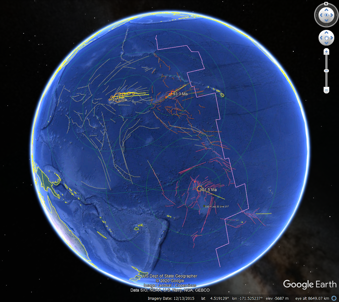
Figure 1.
Google Earth (GE) map centered
on the Mid-Pacific Ocean showing three suspected, Cretaceous-age,
large-impact events resulting in expansive fracture systems and
far-field lithospheric welts
Table 1.
Names, diameters, geographic coordinates and sizes of the suspected
craters associated with the three proposed, large-impact events of
Cretaceous age in the west-central Pacific basin.
Crater Longitude
(dd) Latitude (dd) Diameter (km)
MPM1-1 170.817829
19.056199
60
MPM1-2 171.412033
19.828540
80
MPM1-3 173.566964
19.613020 300 or
80
MPM1-4 173.839099
20.609317
60
MPM1-5 175.047064
20.587932 100
MPM1-6 176.704622
20.717308
80
MPM1-7 178.173939
20.466718
60
Manahiki -163.735657
-5.933358 160
MPM2-1 -172.288833
19.080839
40
MPM2-2 -171.105825
19.934793
60
MPM2-3 -170.267079
20.406090 100
Suspected ~125.0 Ma MPM1 event
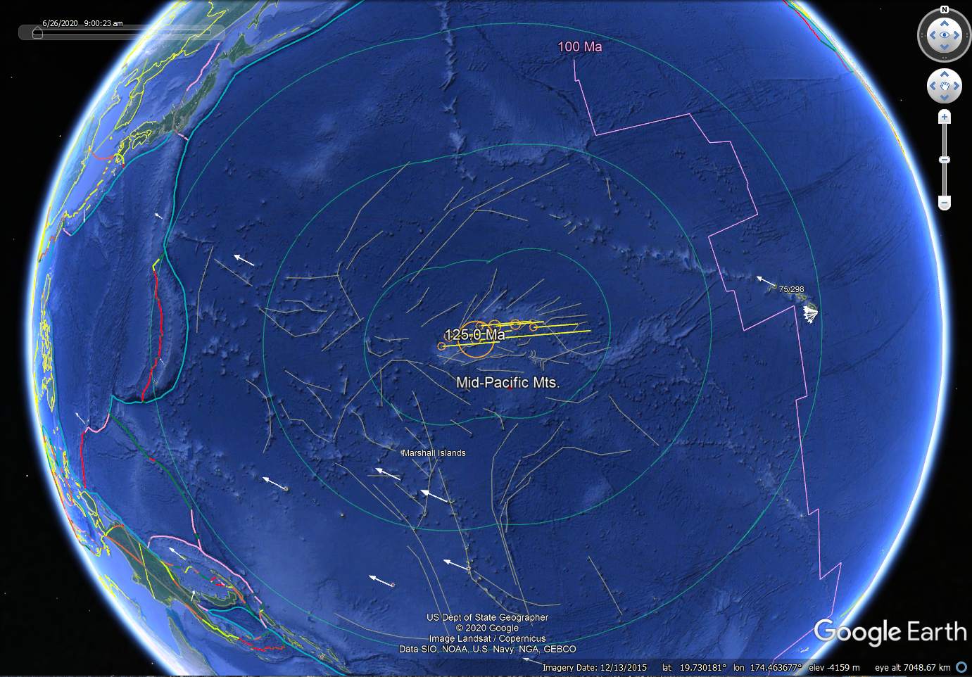
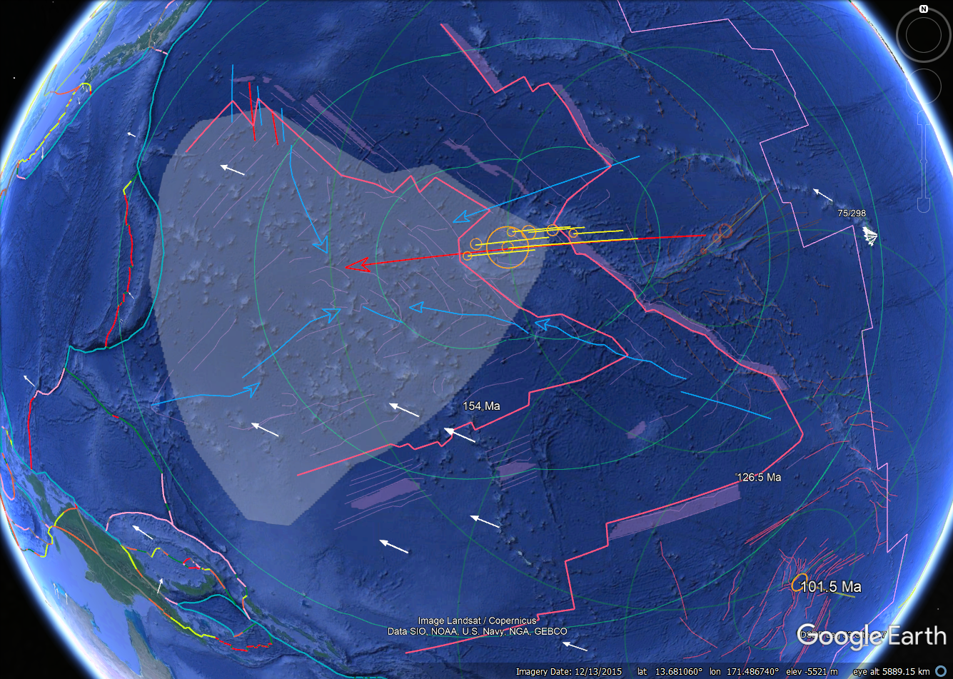
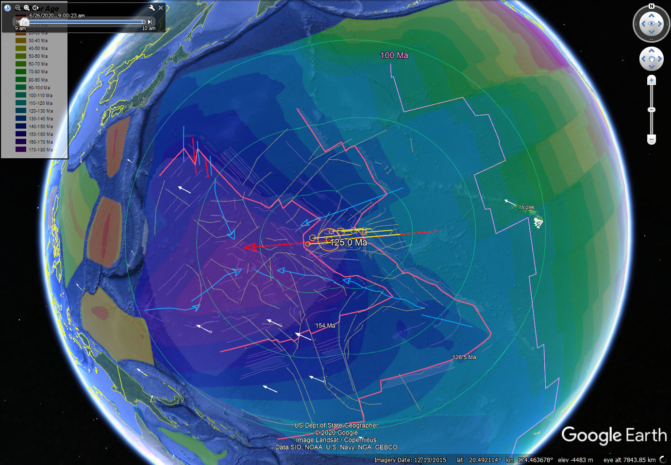
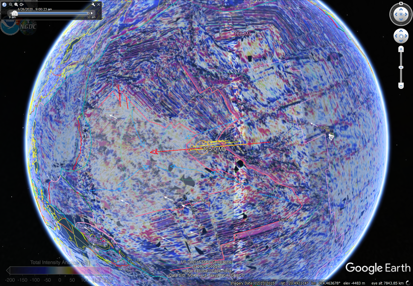
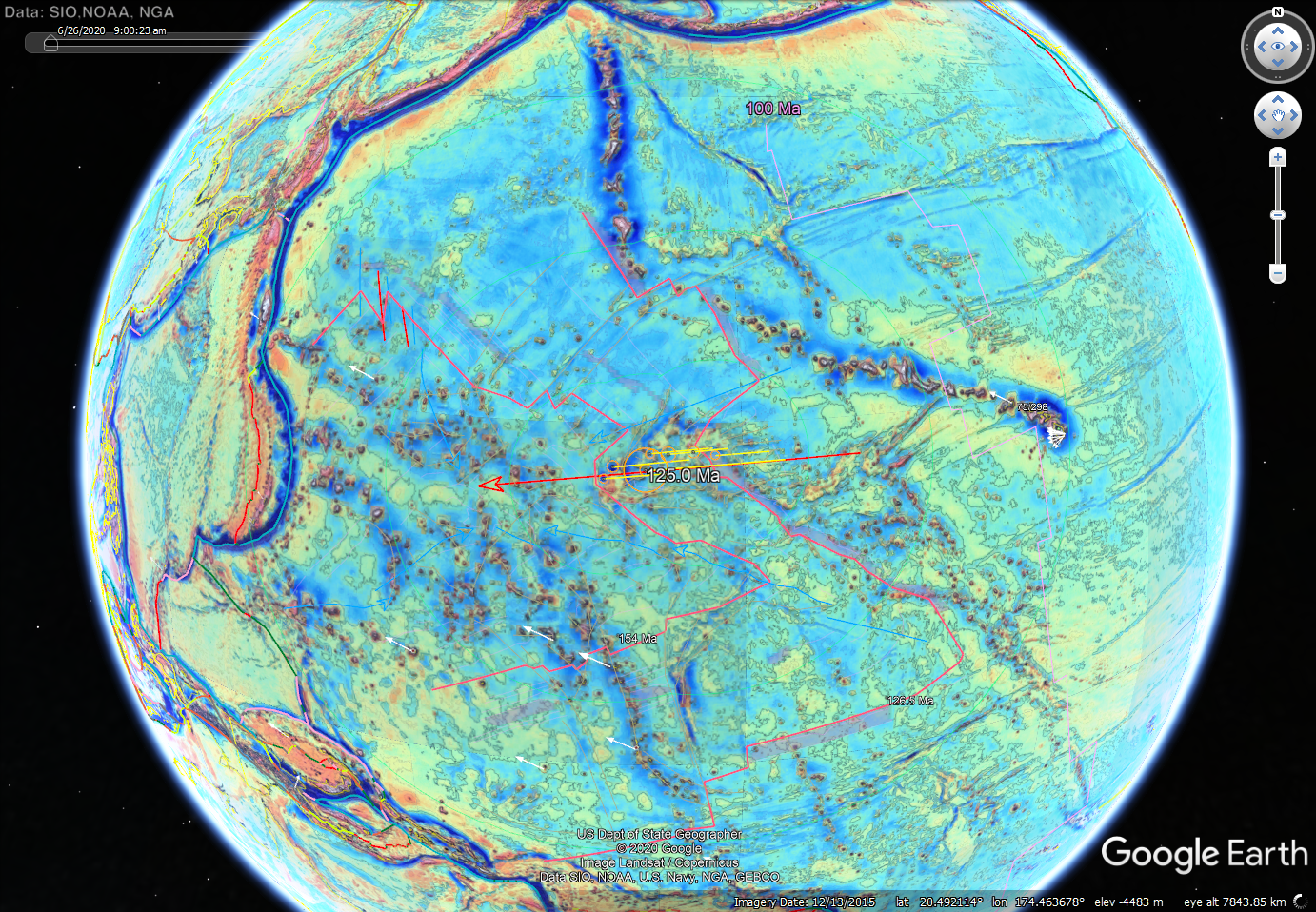
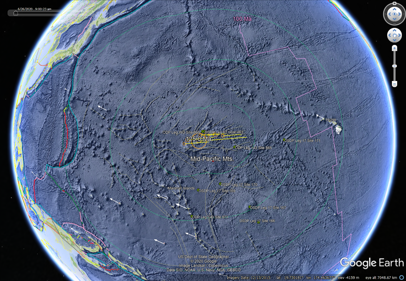
Figure 2.
MPM1 GE maps showing multiple craters in a strewn field.
Ocean-floor physiography (top left) with details (top right) and overlays showing ocean-floor age (middle left), magnetic (middle right) and gravitational (lower left) potential fields, and continental geology
by Era (bottom right). Maps include suspected crater locations and sizes, trajectories, associated crustal fractures, tectonic-plate boundaries, and GPS plate-drift vectors (proportionately scaled with one Hawaii
station showing magnitude). The magnetic field shows
remagnetization through a foreland sector fanning out to the west to the
Marianas trench. Select DSDP and ODP drill sites are shown (lower right) where basement
and cover were obtained.
Suspected ~101.5 Ma Manahiki event
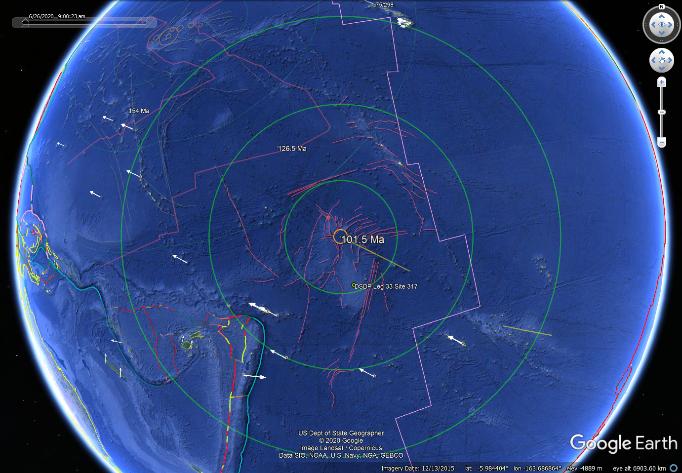
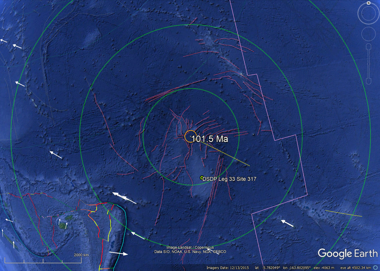 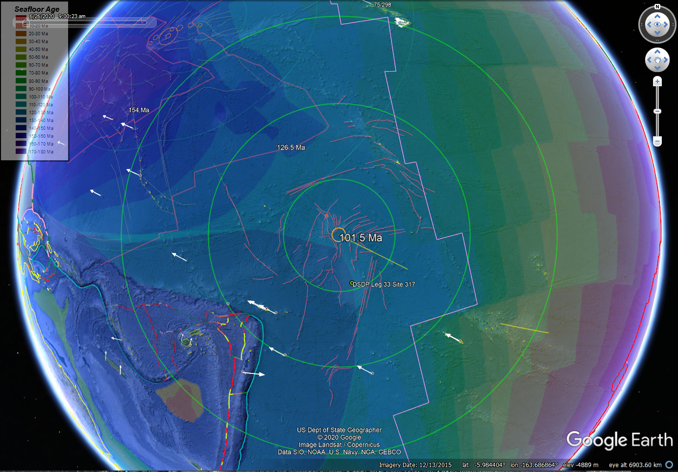
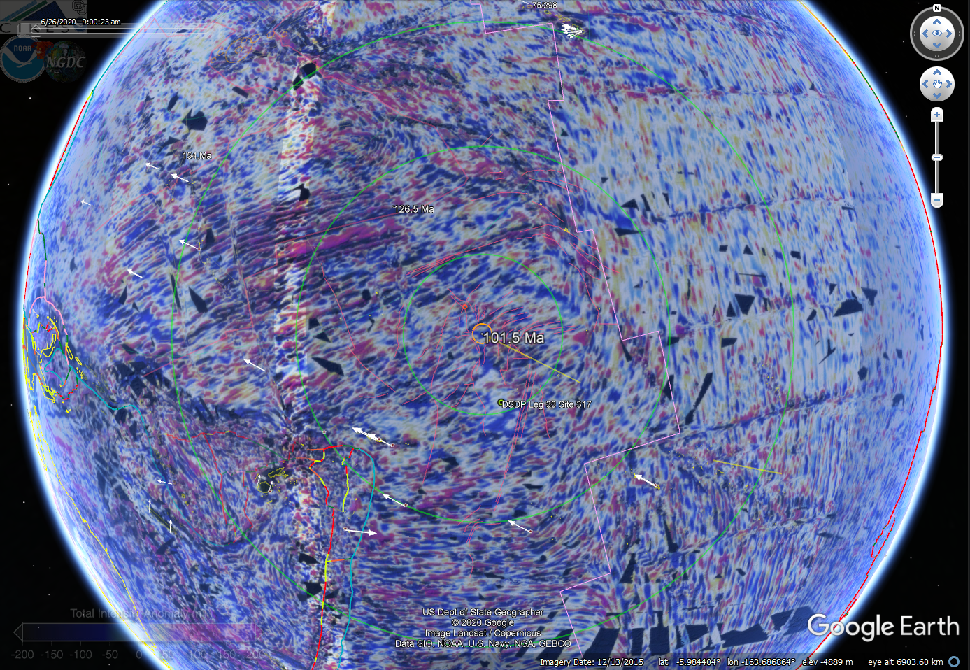
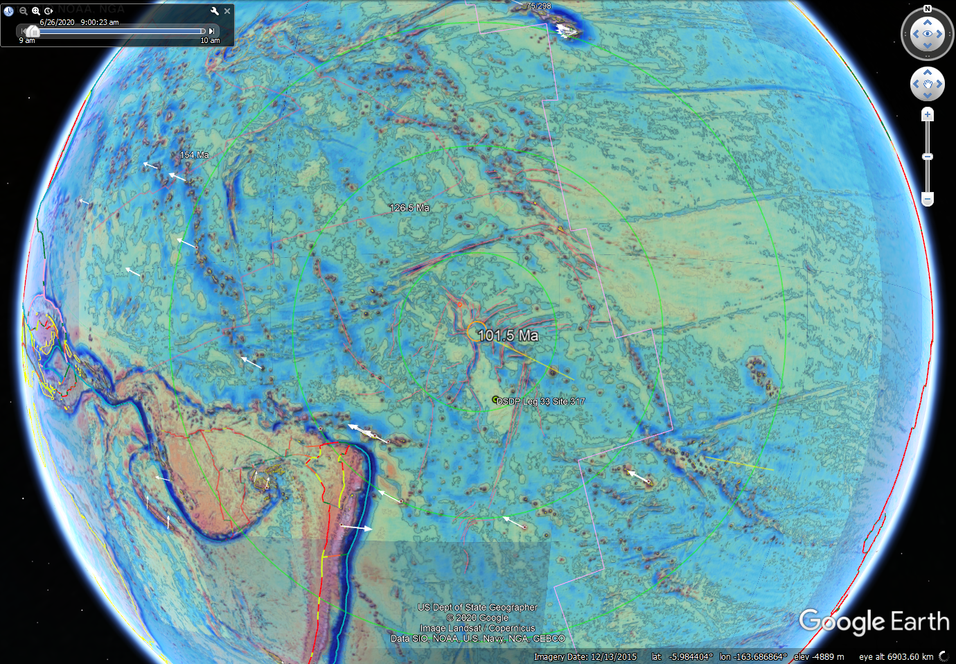
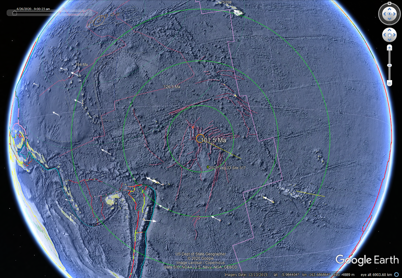
Figure 3.
Manahiki GE maps
showing evidence of a solitary impact crater. Image sequence same as
that detailed in figure 1.
Suspected ~93.5 Ma MPM2 event
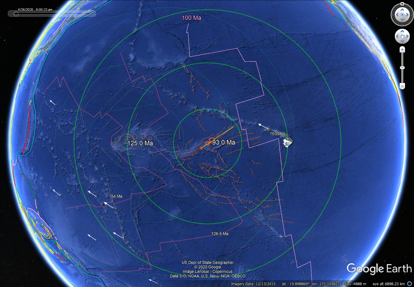
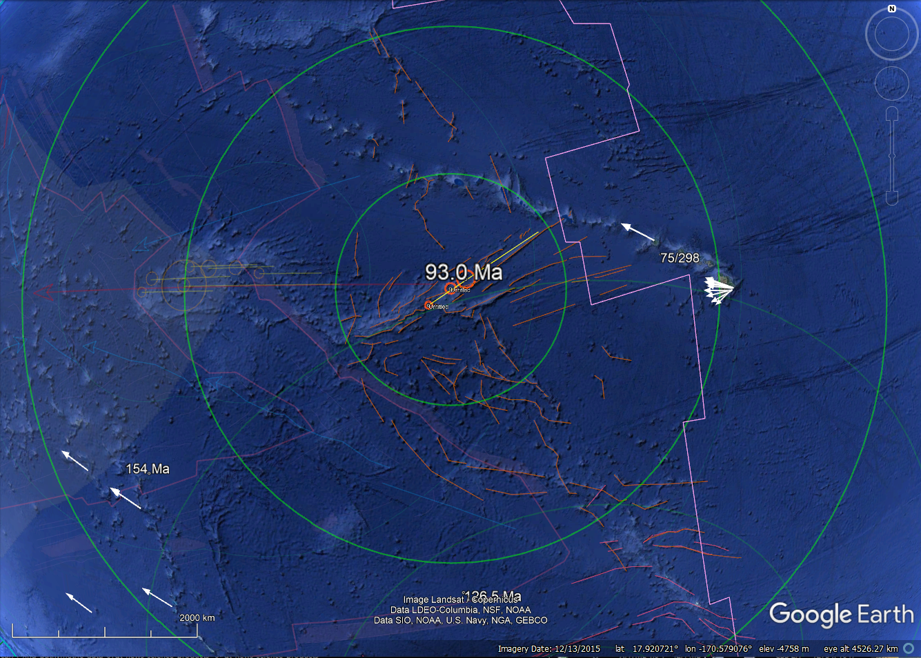 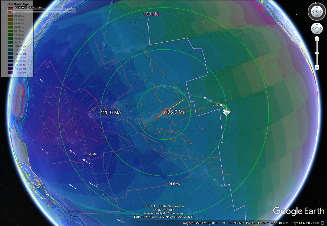
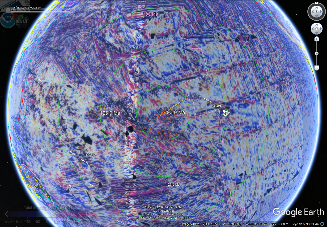 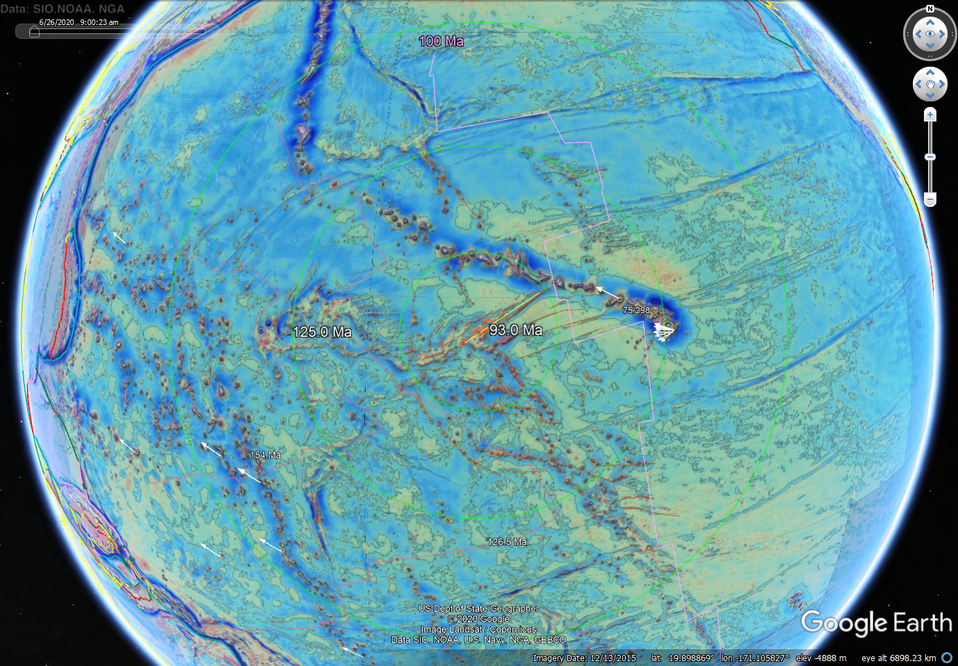
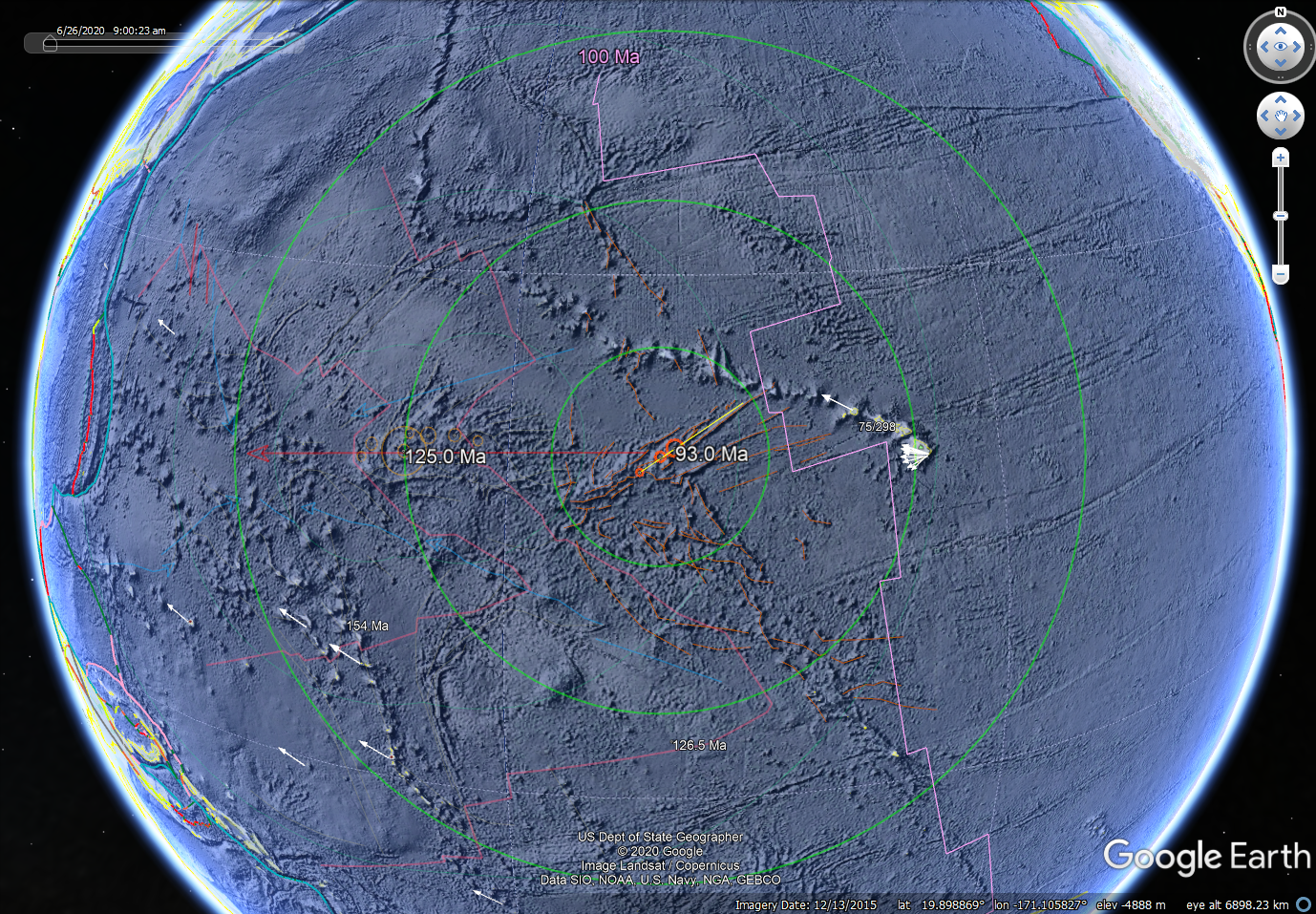
Figure 4.
MPM2 GE maps showing evidence of a strewn
field with multiple craters. Image sequence same as that detailed in
figure 1.
Stratigraphic summary of a Cretaceous
Canadian Arctic stratigraphic sequence
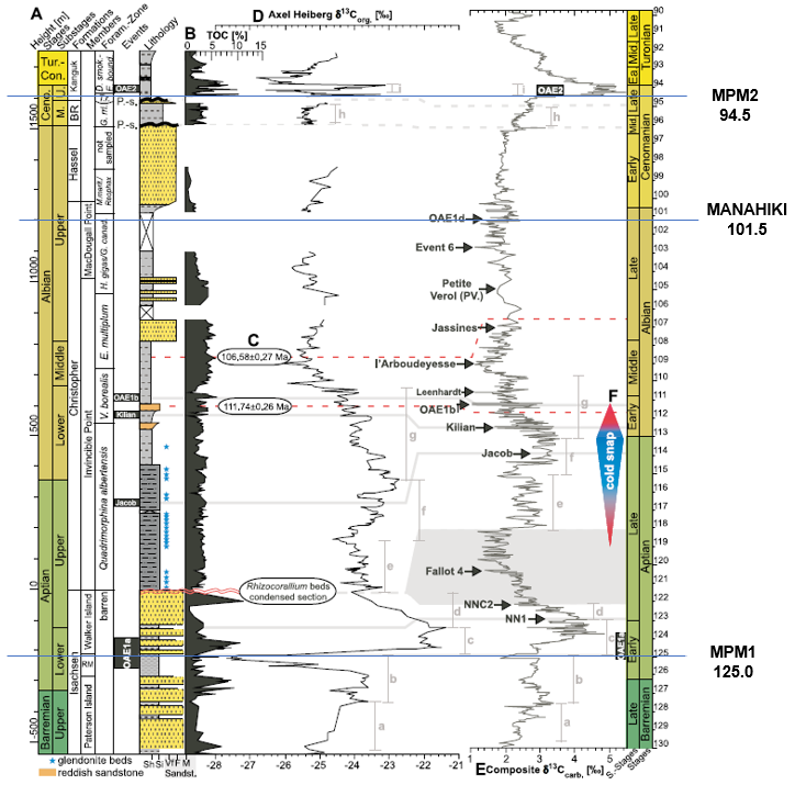
Figure 5.
Sedimentary succession and geochemical records of Axel Heiberg Island,
Nunavut, Canada. The suspected MPM and Manahiki events are added to
Figure 2 of Herrel and others (2015).
Temporal comparison of Phanerozoic
climate change and biological extinction intensity
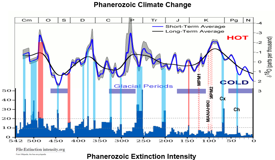
Figure 6.
Combined Wikipedia graphs of
Phanerozoic climate change and biological extinction intensity with
connecting lines emphasizing hot
versus cold events and the timing of
MPM, Manahiki, Chicxulub and Chesapeake impact events.
DSDP stratigraphic record of Site 463
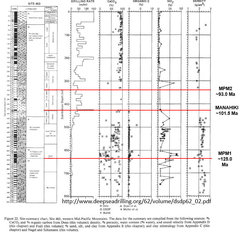
Figure 7.
DSDP
stratigraphic record of Site 463 showing the suspected timing of MPM and
Manahiki events.
Oceanic-impact fracture and fault
patterns
from 4 suspected events <125 Ma.
Figure 8.
Fracture and
fault sets (astoblemes) stemming from 4 suspected oceanic-impact
events. The interpreted patterns are aligned in the same direction
relative to a common trajectory but variably scaled and rotated to allow
comparison of strains. The red arrows show the current, equatorial spin
direction opposing the oblique strikes. Note that the MPM1 impact
trajectory directly opposes the spin direction. Blast sectors shown with
light-green circle and sector lines indicate foreland (F), hinterland
(H), and lateral (L) circumferential positions.
|
Gregory Charles Herman,
PhD
Flemington, New Jersey, USA
Old Pacific mayhem; three suspected bolide-impact events of Cretaceous age with global consequences.
Current problems with plate-tectonic theory *
Methods * MPM1 * Manahiki *
MPM2 *
Discussion *
References
Introduction
Google Earth (GE) is used
to map three, suspected, bolide-impact (asteroid or comet) events that disrupted
Cretaceous Pacific oceanic crust and raised both the Mid-Pacific Mountains (MPM) and
the Manahiki Plateau (figs. 1). The largest and oldest is named MPM1 with an
estimated age of 125.0 Ma, followed by Manahiki at about 101.5 Ma, and the
youngest MPMP2 at about 94.5 Ma, the latter lying physically close and
structurally overlapping MPM1. The older and younger events involve multiple craters lying close
together in large strewn fields (fig. 2 to 4). These extraterrestrial,
catastrophic agents structurally disrupted regions of the Pacific Oceanic basin
and correlate to low-level mass-extinction events stemming from global volcanic,
atmospheric, and sedimentation episodes that lasted eons (figs. 5 and 6). What began as
an exercise to map the visually dominant MPM1 (est. 125 Ma) has resulted in the
addition of the other two sites upon closer scrutiny of the regional
physiographic, geological, geophysical, and temporal data. Each of the
three strewn fields lie amid thickened oceanic crust and have associated
fractures that systematically flare out from the craters and verge toward the
foreland along the interpreted trend of the bolide-descent trajectories. They
also extend to great lengths in lateral sectors of each blast zone. The
fracturing, faulting, and folding mapped for each impact event are the
structural components of "astroblemes" or "star wounds" that
were coined by Dietz (1961), a plate-tectonic patriarch that helped
discover sea-floor spreading. Each set of features occur in close proximity and provide comparable
examples of how oceanic-impact events structurally imprint Earth. This chapter summarizes the mapping techniques and geological
aspects of these three, large impact events in the old Pacific Basin.
The interpretations borrow heavily from prior work
that identified impact-tectonic far-field (ITFF) strains on the North American
Plate stemming from the Chicxulub (~66 Ma) and Chesapeake (~35 Ma) impact
events where resulting, systematic crustal fracturing, faulting, and deep-seated,
multi-ring lithospheric welting contribute to the tectonic architecture of the
North American continent.
Current
problems with plate-tectonic theory
There is only one oceanic impact site included in the
159 known and confirmed bolide impact craters in
Earth's impact-crater database despite two thirds of our planetary surface
being
covered by oceans or marginal seas. Scores of craters must lie undiscovered
beneath thick blankets of sediment across the globe. The confirmation of oceanic
impact structures however is expensive, risky, difficult, and hampered by having to drill the sea bed
lying kilometers below the water surface to additional kilometers depth through
post-impact pelagic and hemi-pelagic sediment to retrieve rock core containing
the geological evidence of shock strains. Such evidence in oceanic, basic crust
can include near-crater breccia, melts, mineral veining, crystal
transformations and dislocations, and shatter cones. But by closely examining the
geometric expression of the fracture systems that gave rise to the
oceanic mountains with respect to 1) seafloor age, 2) their gravitational and magnetic
expressions, and by 3) applying historical and structural-geological principles, the geological
mysteries of the oceanic realm begin to unfold. As characterized here,
many of these extensive fracture systems are secondary structures imparted by
large (> 1 km diameter) asteroid or comet (bolides) impacts that occur
periodically through time to impart far-reaching, tectonic strains in Earth's
lithosphere when it is suddenly shocked and rumpled from an extraterrestrial
strike.
Not only do impacts
accrete new material to Earth, but they also instantaneously impart extensive
brittle and plastic structural damage to the crust and lithosphere together with
producing severe atmospheric disturbances, craters, and pulverization
(communition) of the projectiles. At this time we are only beginning to
recognize and catalogue far-field strains and study the manner in which ground
energy is partitioned into the strain responses to account for these massive
energy fluxes. There is a lack of experimentation and mathematical modeling to
account for these far-reaching strains like those seen surrounding the two- well
known, large, Cenozoic-aged impacts on marginal continental lithosphere of the
North American Plate (see posts 1 and
2). Humans cannot reproduce the physical conditions of large, hypervelocity impacts
because of the process scale, but laboratory tests
do help
constrain crater morphology (see Gault references). On the other hand, the
seismic efficiency, or the amount
of the bolide kinetic energy that gets transferred into ground energy upon impact is poorly
constrained and will vary depending upon impact velocity, incident
obliquity, and both projectile and target compositions. The velocity variable in
particular is a primary factor, because when a strike opposes the host bodies'
direction of planetary rotation and/or circulation, the resulting impact
velocity, and physical expression of resulting strain fields would be additive, as is the case for the
interpreted events mapped below. Most
laboratory experiments derive impact variables based on firing projectiles into
static bodies, and the physics of colliding bodies is very complex and often
limited by having one body at rest. Such conditions inadequately account for the tectonic
energy arising when spinning bodies moving in opposite directions collide. The
online Earth
Impact Effects Program states that the minimum impact velocity on Earth is
11 km/s, with typical impact velocities of 17 - 51 km/s for asteroids and comets
respectively. Maximum impact velocities of 72 km/s are attained when Earth
collides with bodies moving in opposite directions. Jutsi
and others (2015) summarize the state of the art of modeling asteroid collisions
and tectonic processes and conclude that there have been major advances in the
past decade, but numerical simulations need to become of 'higher fidelity' in
order to just match the results to
conditions seen from physical experimentation.
Mathematical validation awaits as it's necessary to accurately identify the
physical limits and impact parameters to achieve realistic models.
Methods
These interpretations
primarily used GE as a geological mapping tool. Recognition of the impact features
rely principally on the physiographic expression of the seafloor,
compiled from decades of work conducted by the U.S. National Oceanic and
Atmospheric Administration (NOAA).
The three locations coincide with large, ocean-floor rises that are
also large igneous provinces (LIPS) where oceanic crust is thickened by
post-impact magmatism in addition to material accretion from bombardment. The number of
craters and the
composition of the bolides are unknown because deep-sea (DSDP)
and ocean-drilling (ODP)
programs have not sampled the suspected crater
locations, although some are very close (figs, 2 to 5). The suspected crater
locations and dimensions are estimates based on the following aspects
illustrated in figures 1 to 4.
1) GE sea-floor
physiography
2) ocean floor ages with the 100 Ma magnetic isochron highlighted
3) regional magnetic and gravity potential-field maps
4) fracture geometry that systematically radiates outward from each site
5) crustal-floor fold geometry derived from the magnetics
6) far-field, radial fractures and lithosphere welts or 'rings'.
GE placemarks
(points), polylines, and polygons were used to highlight and label features.
Crater-rims and radial traces of hypothetical crustal arches lying
circumferential to
craters at 660, 1600, and 2900 km. were generated using the free GE application
Range Rings to generate the
polyline circles. For strewn fields involving multiple craters, the overlapping
arch traces were merged and pared using
QGIS so that only those traces enveloping all
others of the same value were saved. That is, only the most external traces were
saved to eliminate clutter. Vertical crustal deflections associated with these
far-field, radial arches and intervening troughs are estimated to be about 0.5
to 1.5 km amplitude and are discussed further in the concluding discussion
below.
The surface traces
of systematic fractures and faults were digitized using a hand-held computer
mouse with the caveats that they lie within 2900 km radius of the crater(s) and
their extent is limited to oceanic crust that is older, or of the same age as the
interpreted event. A GE theme of
the ocean-floor ages (Muller and others, 1997) is included in a 2012 GE computer
file named
Dynamic Earth.KMZ that was compiled by Laurel Goodell of Princeton
University (2012) and used here to help constrain the timing of each event. The
aforementioned KMZ file also includes the differentiated tectonic-plate
boundaries included in the illustrations (Bird, 2012).
The fold interpretation
in the old Pacific basin is derived from the
aforementioned magnetics theme. Ocean-floor isochrons of approximate age 126.5
and 143 Ma age are highlighted in figure 2 (top right) to show that the trace of
a major, central antiform lies parallel to the interpreted trend of the bolide-flight
path. As portrayed, the anticline trace reaches over 2700 km distance. This impact event apparently wrinkled the ocean crust. I'm
uncertain if all of the folding mapped in figure 1 and 2 stem from this one
event, or if the triangular shape of the oldest ocean crust to the west was
inherited from prior tectonic events. This will also be discussed further below.
To capture and
compare the geometry of the fracture systems interpreted for
each event, a
global white mask was used as a backdrop to capture their surface-trace
expression. All fractures were colored black, set to a line
width of 2.0, then each fracture set was centered in the display before being
captured, copied, and embedded into MS PowerPoint software for further
illustration (fig. 8).
Other GE themes
include a
KMZ file of
the results of the U.S.-funded deep-sea-drilling-project (DSDP) and subsequent
ocean-drilling program (ODP) that provide detailed geological records of both
ocean-crust basement and the sedimentary cover (fig. 8). The
plate-drift vectors
are from another
KMZ compilation based on global-positioning-systems (GPS) measurements from
ground-fixed receiving stations.
The GE
theme-transparency functions were used extensively to prepare the illustrations that are captured screen displays of GE, once each figure was
fashioned to emphasize the intended physical relationships. The
theme-transparency function is what affords GE such great utility in integrating
complex scientific themes covering large areas in great detail. Earlier structures are set to a transparency of about 50% so that they become
muted with respect to the younger, emphasized structures in turn. For example,
MPM1 and Manahiki astoblemes were made semi-transparent to emphasize the
MPM2 astobleme in figure 4. The following
sections provide more detailed aspects of each event prior to a concluding
discussion.
MPM1
MPM1 is the oldest,
most expansive and energetic event interpreted to stem from multiple strikes by
a fragmented parent asteroid or comet. The suspected craters lie beneath
blankets of Cenozoic pelagic oceanic sediment that are generally less than 1
kilometer thick as sampled at DSDP site 463 (fig. 7). The names, locations and
diameters of each crater are listed in table 1. As mapped, there are seven with
the smallest about 60 km in diameter, and the largest either 80 or 300 km,
depending upon whether it's a multi-ring structure or just a very large crater.
The crater form of these features was previously noted by Wilde (2010). The fracture, fold and fault geometry reflect a
probable, moderate angle of projectile descent (<45o and >30o)
from azimuth 085o toward 265o (fig. 2). The age and magnetic expression of the crust
indicates that the lithosphere was wrinkled by these impacts, resulting in a
series of major antclines and synclines in oceanic
basement older than
about 125.0 Ma. The folds have gently-plunging axes trending sub parallel to the
interpreted flight paths (figs 1 and 2). The fracture system lies symmetrically
disposed about the strewn field and verges westward towards the direction of
incidence along the trend of the central anticline axis. The foreland sector situated
downrange of the strewn field shows melting and magnetic alteration of the oceanic crust
within a region emanating from the craters and fanning out to the west toward
the Marianas trench (fig. 1 and 2). The foreland region is where the majority
of the absorbed ground energy was focused (fig.
8).
Other
impact-tectonic far-field (ITFF) strains include the lithosphere arches and
troughs lying circumferential to each crater as illustrated having arch traces located at 660, 1600, and 2900 km radial
distance from crater centers. These welts have amplitudes on the order of 1.0 to
1.5 km, varying occurrences and physiographic expressions. They are
clearly seen in places, like along the 2900 ring to the south and west of the
strewn field where the
seafloor attains elevation of almost 2 km structural relief from the nearby
abyss. But in other places, they are not apparent because of uncertain reasons,
two of which may be tectonic inheritance and/or tectonic overprinting. These
points are discussed further at the end of this post.
The timing of MPM1
points to correlation with a
global atmospheric carbon disturbance referred to as
the oceanic anoxic event 1 (OAE1) when carbon-enriched
silt and clay was deposited in worldwide basins for almost one-million years (fig.
5), and
major perturbations of seawater chemistry and climate occurred (Schlanger
and Jenkyns, 1976; Jenkyns,
2010).
It also happened just after the onset of the Mesozoic thermal maximum (fig.
6) when worldwide hot-spots were flaring to
produce large-igneous provinces (LIPS). This was a period of global biological and tectonic
change that was probably spurred on by this event involving multiple impacts in
a strewn field covering an estimated 140,000 sq. km. in the center of the Pacific
Ocean (figs. 1 and 2). The associated seamounts of the Mid-Pacific Mountains
now reach over 2 kilometers relief from the nearby oceanic abyss and although
many aspects of these events are poorly constrained, the geological and
geophysical evidence pointing to their occurrence as major impact strewn fields
is abundant.
The current direction of plate drift is sub-parallel
to the inferred descent azimuth indicting a possible link between impact
momentum and plate traction. It's also possible that the
Hawaiian-Emperor seamount chain developed along deep-seated faults
imparted by this collision that tapped asthenosphere melts then, and continue
today to feed magma at
spots with fault-mediated ascent. The Emperor seamount chain is situated to the
North of the strewn field and occupies a lateral blast sector with large
faults that are mirrored in the opposite southern sector with surface
traces thousands of kilometers long. The Hawaiian seamount-island chain rests
in crust younger than 125 Ma and therefore the surface trace of those fractures were not traced as part of the MPM1 set.
However, that is not to say that MPM1 didn't impart deeply penetrating
fractures that persist at lower lithosphere and upper asthenosphere depths to
facilitate
new oceanic crust growth in their wake. This too will be considered further below.
Manahiki
The Manahiki event appears to be a solo impact, although
small, circular depressions occurring close by may prove to be smaller
impacts, and/or spalled projectile fragments (fig 3). The crater as portrayed is
160-km in diameter and the bolide is assumed to have had a moderate angle of
descent (<60o and >45o)
from azimuth 115o toward 295o (fig. 2). The strain
expression of the event is the most uniform of the three having the associated
fractures fanning symmetrically outward in the wake of the crater and
verging northwest toward and into the foreland sector. However this event shows less foreland
fracturing in comparison to MPM1, which may reflect a relatively higher incident angle
of impact. Faults occupying lateral sectors
are long and continuous and link together to form a basin depression extending into the
foreland sector, probably formed from an impact, plunger effect. The astrobleme is remote to the other two which may explain its relatively pristine
strain expression, reflecting inheritance of ordinary oceanic crust at the
impact center itself. Therefore, the resulting scar serves as a "type" strain
response to an oblique, hypervelocity bolide impact in oceanic crust, and a
basis for comparing the geometry to that at other sites (fig. 8).
The timing of the Manahiki event is uncertain. It appears
younger than MPM1 because the 2900-km arch stemming from MPM1 seems to limit
the foreland disruption of the Manahiki event. That is, MPM1 ITFF strains
interfere with Manahiki's scarring by limiting their foreland propagation. The regions around a
large impacts like MPM1 become strain hardened from brittle and plastic strains
distributed in the lithosphere and asthenosphere that include fracturing,
folding, faulting and
melting. These secondary structures strengthen
material that they form in and give rise to regions having decreased compressibility and
higher shear strength with respect to unstrained regions having slightly
different material strain responses. The geometry of such interactions
have only begun to be recognized and characterized and also occur where MPM2
strains overlap and interfere with MPM1 strains.
MPM2
The MPM2 event is portrayed here as a multiple-impact event having three craters
with diameter of 40, 60, and 100 km (table 1). The type of projectiles are
unknown, but the associated fracturing appears to result from a set of oblique strikes
having moderate-
to low incidence (<45o and >30o)
from azimuth 58o toward 235o (fig. 2). Being the
youngest event of the three, the associated ITFF strain
features overlap and interfere with by the ITFF strain features mapped for both MPM1
and Manahiki (figs. 1 and 4). This astrobleme has a comparatively wide fault- and
fracture expression extending to far reaches in the lateral sectors that may
reflect a
selective strain response from indenting previously strained lithosphere that
hampers the foreland
transmission of energy from this later event, as if 'running into a wall' that was
erected by MPM1 in the form of the large central fold-limb (figs. 1, 2 and 4).
MPM2 is correlated to Oceanic Anoxic Event 2 (OAE 2) in the late Cenomanian
that involved LIP volcanism as seen by increased accumulation rates of marine organic carbon in globally distributed
basins from massive
CO2
atmospheric releases
(Turgeon
and Creaser, 2008; Du
Vivier et al., 2014; Holmden
et al., 2016)
that may have limited available
bio nutrients for marine
organisms (Jenkyns
and others, 2017).
Stratigraphic, geophysical, and structural geological evidence point to a
disruptive marine event that occurred at the Cenomanian-Albian (C/A) time
boundary and coincident with marine mass extinctions.
Discussion
The representation of buried craters lacking
seismic-reflection coverage is risky because they await confirmation through
expensive sea-borne drilling operations that gamble on their existence. Hence,
the lack of confirmed oceanic impact structures. Even when there is seismic and
drilling data, an impact interpretation is not always forthcoming because
drilling is fraught with uncertainty stemming from sampling gaps and having but
one point of geological observation that may be insufficient to
confirm a large cratering event. These
suspected crater locations are constrained using only morphological, structural,
and geophysical criteria and if they are in fact realized, their form may vary
greatly from the circular craters represented here. Experimentation shows that
low-incidence, oblique strikes can leave scars that are shaped in tear-drop or
elliptical forms, and impacts striking at low-incident angles can ricochet off
Earth's surface and expel fragments that splash down elsewhere. Much work
remains in proving their existence before they are accepted as part of our
tectonic heritage. And in that respect, associated strain hardening of the lithosphere, ITFF strains,
and punctuated, geodynamic perturbations also become part of this heritage, as
seen for the
Chicxulub impact crater that sits at the center of a tectonic hub fixed on the
Gulf of Mexico having the surrounding tectonic plates rotating about it in
concert with a lack of central seismicity to within 660-km radius of the crater
(Herman, 2006). Strain hardening is a common repair response to deformation of
material having the ability to heal, and as familiar as when our bones fracture
and heal with more strength than before from calcium deposition during repair.
The network of healed fractures, mineralized fault surfaces, and compacted
material imparted by impacts cause the lithosphere to strain resulting in increased
rigidity and hardness in comparison to unstrained material, and therefore will
preferentially resist subsequent strains relative to unstrained or less-strained
regions. The great transform faults that now span the mid- to eastern Pacific
Ocean floor were probably inherited from these suspected events, among others
that have yet to be recognized. The systematic flaring outward of the deeply
penetrating fractures in the wake of each event occur in tectonic
hinterlands (fig. 8) and are apparently utilized as subsequent sutures between
plate segments that accommodate growth and adjustment as the plates drift and twist about on the surface of a
spheroid. Overlapping ITFF strain fields are mapped around two,
large, confirmed impacts
on the North American plate (NAP, Chapters 1 and 2), and now there are three
suspected oceanic impacts having overlapping strain fields that allow a
comparison among each other and to the continental ones. The latter show ITFF epierogenic
uplifts with radial arching at ~1600 and 2900-km radii from craters as seen with
the
Adirondack Mountains and the Colorado Plateau, whereas some of the deepest
troughs lie at the intersections of overlapping rings. Earth's
crust is highly anisotropic from the combined effects of both orogenic and
impact-born
strains that must overlap and interfere with one another to influence the manner in
which seismic energy becomes transmitted and dissipated from
younger events.
Impact effects including atmospheric entry, impact
crater formation, fireball expansion and thermal radiation, ejecta deposition,
seismic shaking, and the propagation of the atmospheric blast wave can be
calculated at various distances from any impact point using an
on-line
computer program that requires projectile, impact, and target input
parameters. But determining the physical nature of suspected, hidden
features is purely speculative and there is no way of determining if a strewn
field was generated by projectiles that were fragmented before or after
atmospheric entry, let alone their impact velocities. Also, having multiple
craters of uncertain dimensions in a strewn field makes it nearly impossible to
estimate input parameters for a single, parent projectile if there was only one.
Bolide clusters or fragments can impact a planetary or moon surface
with a series of tightly-spaced projectiles arranged like 'a string of
pearls'. Humans recently witnessed such an event on Jupiter
with the Shumaker-Levy event in 1997, the first modern, direct observation of an
extraterrestrial collision of Solar System objects. Calculating impact energies
stemming from big events like those is one thing, but portioning
that energy into the various strain responses realized by the host is another,
especially because we have such a poor understanding of seismic efficiency, or
the amount of impact energy that becomes grounded. Much more experimentation is
needed in order to understand how seismic efficiency varies with impact
conditions before we truly can understand the limits and strain effects stemming
from these catastrophic
disturbances.
The ocean-floor folding mapped in association with MPM1
is the first instance that I know of where large-scale crustal folding that is
not radial to an impact crater is attributable to a
large-bolide impact on Earth. If the MPM1 location and
the proposed secondary structures from this suspected event are proven, then structural folding on the order of alpine scales becomes
part of an astrobleme. As originally defined, they are the 'root structures' of
ancient meteorites that are exposed by uplift and erosion over time (Dietz,
1961). Large-scale, radial welting of the crust
is reported by Dietz in this defining work:
"Practically nothing of the original crater remains, but
geological study has revealed a worn-down "dome" of granite 26 miles in diameter
surrounded by an upturned and even partially overturned collar of Pre-Cambrian
rock. A great ring syncline (the trough of a fold in the rocks) surrounds the
collar, making the entire deformation 130 miles in diameter. Geologists have
traditionally attributed this huge structure to a long sequence of tectonic
events. ".
The term 'astrobleme' therefore includes
large-scale circumferential folding and is extended here to include the complete array of ITFF fracture, fault, and
fold strains mapped for each event.
A comparison of the Phanerozoic record of climate change
versus extinction intensity shows that biological extinction events occur
during both hot and warm climates (fig. 6). But any causative link between
the climate change and extraterrestrial-born events is speculative, but
certain to reflect in some measure such large, energetic, disruptive events as those
outlined here and prior chapters of this blog. And so to conclude, I offer some
thoughts regarding the heaping of speculation. This
work compliments and supports earlier observations and thoughts concerning ITFF
strains that were first discovered and reported surrounding the Chicxulub and Chesapeake impact
craters on the continental NAP (Herman, 2006).
Epierogenic
and mass movements associated with such events are the resulting plastic and brittle strain
responses when hard-shelled, plastic spheroids spinning and circulating
through space in time get struck. Impacts events like these should be soon
recognized with more regularity from using widespread modern technology to portray our environment with
unprecedented detail and eloquence. So although it may seem like speculative
events are used to constrain other speculative events, I assure you that by closely inspecting what is proposed and detailed here, you
will find plausible mechanisms and explanations for processes and features that
are soon to become part of our tectonic tapestry as it continues to be
woven.
References
Bird, Peter (2003) An updated digital model of plate boundaries, Geochem Geophy
Geosystems, v. 4 no. 3, p. 1027, converted into Google Earth format by T. C.
Chust.
Dietz, R. S.,
1961, Astroblemes: Scientific American, vol. 205, no. 2, p. 50-59.
Earth Impact
Database, 2015: Planetary and Space Science Centre, University of New Brunswick,
Canada, www.passc.net/EartthImpactDatabase/
Gault, D. E., Wedekind, J.A., 1977, Experimental hypervelocity impact into quartz sand – II,
effects of gravitational acceleration, in Roddy, D.J., Pepin, R.O.,
Merril, R. (Eds.), Impact and Explosion Cratering: Pergamon, New York, NY, p.
1231– 1260.
Gault, D. E., Wedekind, J.A., 1978, Experimental studies of oblique impact: Proc. Lunar
Planet. Sci. Conf. 9, p. 3843–3875.
Gault, D. E., Quaide, W., Oberbeck, V., 1968, Impact cratering mechanics and structures,
in French, B., Short, N.M. (eds.), Shock Metamorphism of Natural Materials:
Mono Book Corp., Baltimore, MD, p. 87–90.
Herman, G. C., 2006, Neotectonic
setting of the North American Plate in relation to the Chicxulub impact:
Geological Society America Abstracts with Programs, Vol. 38, No. 7, p. 415
Herrle, J. O., Schröder-Adams, C .J., Davis, W., Pugh, A. T., Galloway, J. M.,
Fath, J., 2015, Mid-Cretaceous High Arctic stratigraphy, climate, and Oceanic
Anoxic Events: Geology v. 43 no. 5, p. 403–406
https://doi.org/10.1130/G36439.1
Jutzi, M, Holsapple, K., Wünneman, K., and Michel,
P., 2015, Modeling asteroid collisions and impact processes: Asteroids, no.
IV, p. 1-21.
Karig, D.
E.; Peterson, M. N. A.; Short, G. G. (1970). "Sediment-capped guyots in the
Mid-Pacific Mountains". Deep Sea Research and Oceanographic Abstracts. 17 (2):
373–378. Bibcode:1970DSROA..17..373K. doi:10.1016/0011-7471(70)90029-X.
Kroenke, L.
W.; Kellogg, J. N.; Nemoto, K. (1985). "Mid-pacific mountains revisited".
Geo-marine Letters. 5 (2): 77–81. Bibcode:1985GML.....5...77K.
doi:10.1007/BF02233931.
Kuhnt, W., A. E.
Holbourn, S. Beil, M. Aquit, T. Krawczyk, S. Flögel, E. H. Chellai, and H.
Jabour (2017), Unraveling the onset of Cretaceous Oceanic Anoxic Event 2 in an
extended sediment archive from the Tarfaya-Laayoune Basin, Morocco,
Paleoceanography, 32, 923–946, doi:10.1002/2017PA003146
Maus, S., U. Barckhausen, H. Berkenbosch, N. Bournas, J. Brozena, V. Childers,
F. Dostaler, J. D. Fairhead, C. Finn, R. R. B. von Frese, C. Gaina, S. Golynsky,
R. Kucks, H. Lühr, P. Milligan, S. Mogren, D. Müller, O. Olesen, M. Pilkington,
R. Saltus, B. Schreckenberger, E.Thébault, and F. Caratori Tontini, EMAG2: A
2-arc-minute resolution Earth Magnetic Anomaly Grid compiled from satellite,
airborne and marine magnetic measurements, Geochem. Geophys. Geosyst., under
review, http://geomag.org/info/Smaus/Doc/emag2.pdf
Muller et. al., 1997, Digital isochrons of the world’s ocean floor, J. Geophys.
Res., 102, 3211-3214.
Thiede, J.;
Dean, W. E.; Rea, D. K.; Vallier, T. L.; Adelseck, C. G. (1981). "The geologic
history of the Mid-Pacific Mountains in the central North Pacific Ocean: a
synthesis of deep-sea drilling studies". Initial Reports of the Deep Sea
Drilling Project. 62: 1073–1120. doi:10.2973/dsdp.proc.62.162.1981. Retrieved 2
September 2018.
Wilde, P. (2010). "Supervolcanoes
in the Mid-Pacific Mountains?". AGU Fall Meeting Abstracts.
Winterer, E. L.; Metzler, C. V. (1984). "Origin and subsidence of guyots in
Mid‐Pacific Mountains". Journal of Geophysical Research: Solid Earth. 89 (B12):
9969–9979. Bibcode:1984JGR....89.9969W. doi:10.1029/JB089iB12p09969.
Winterer, E.
L.; Sager, W. W.; Firth, J. V.; Sinton, J. M. (1995). "31. Synthesis of Drilling
Results From the Mid-Pacific Mountains: Regional Context and Implications".
Proceedings of the Ocean Drilling Program, Scientific Results. 143. Retrieved 2
September 2018.
Current problems with plate-tectonic theory *
Methods * MPM1 * Manahiki *
MPM2 *
Discussion *
References
Impacttectonics.org