![]() TECTONICS BLOG
Rev. 12/31/2021
TECTONICS BLOG
Rev. 12/31/2021
|
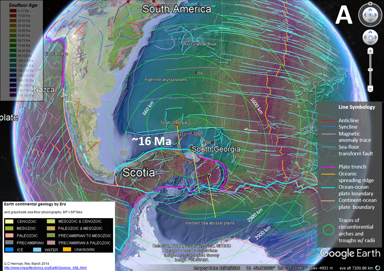
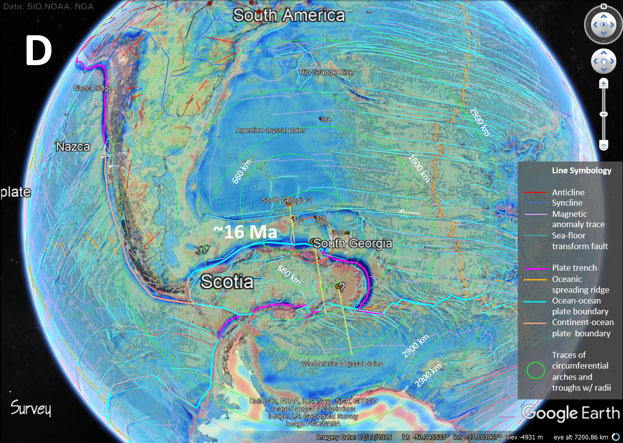
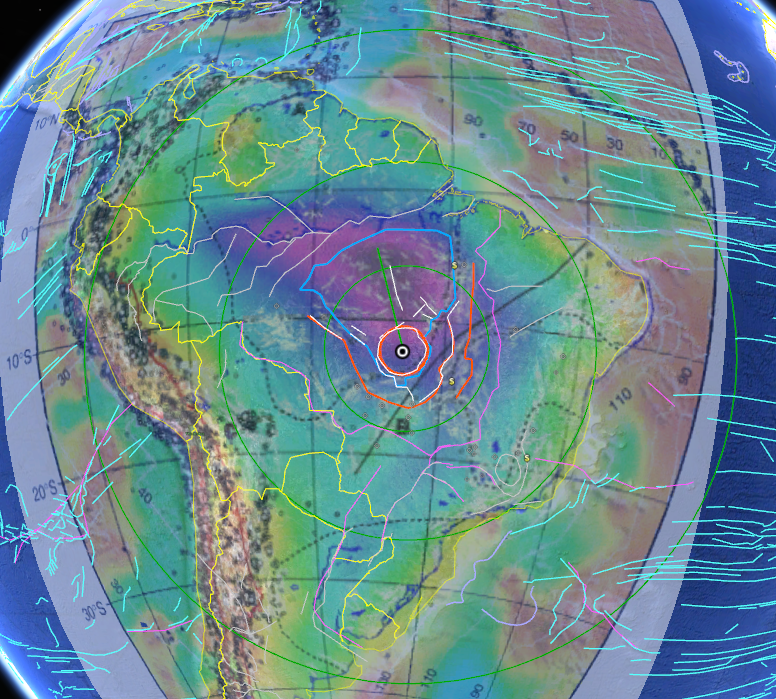
Click on an image to enlarge it  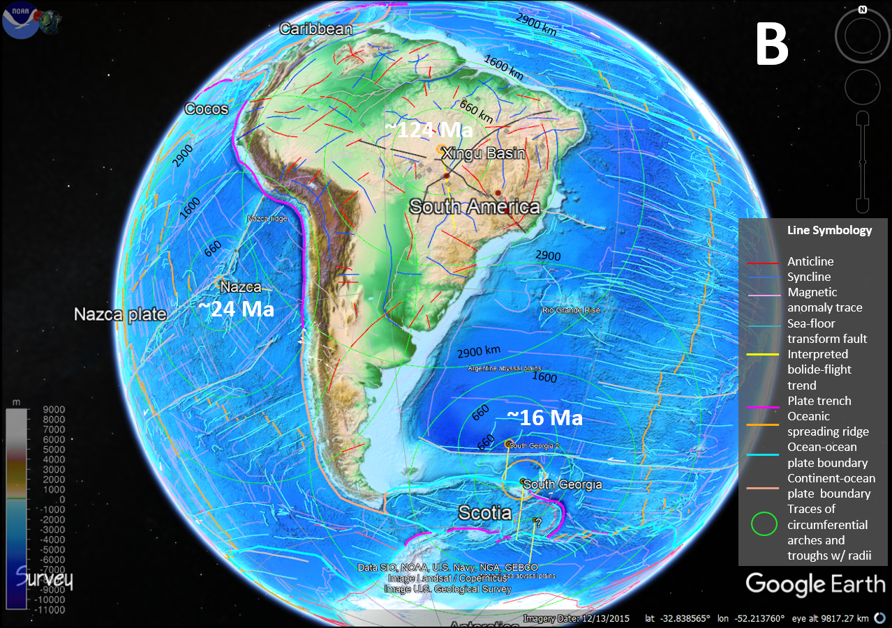 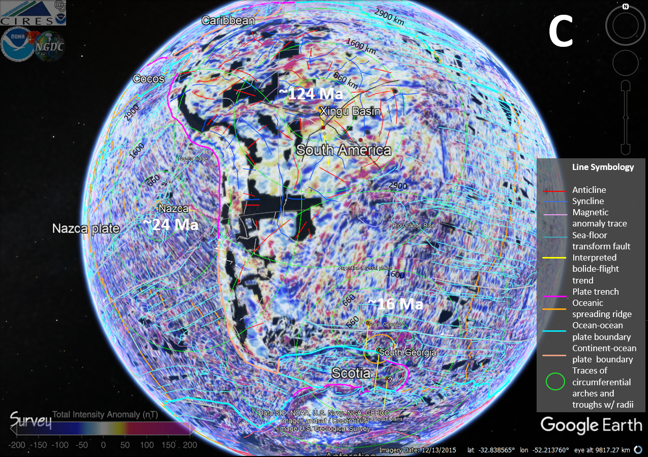 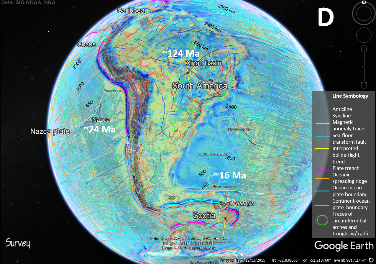 Figure 1. Four GE views of three suspected, large, hypervelocity bolide-impact locations in the South American region of estimated ages of 124 Ma (Xingu) , 24 Ma (Nazca) and 16 Ma (South Georgia) on 4 different base maps including: A. Sea-floor age and continental geology by Era B. Global topography, C. Global magnetic anomalies, and D. Global gravity anomalies.
Figure 2. A set of suspected, large impact craters are strewn about South Georgia Island the southwestern Atlantic Basin. Top to bottom global base themes include A) continental geology by Era and sea-floor age, B) topography and C) magnetic and D) gravity anomalies. 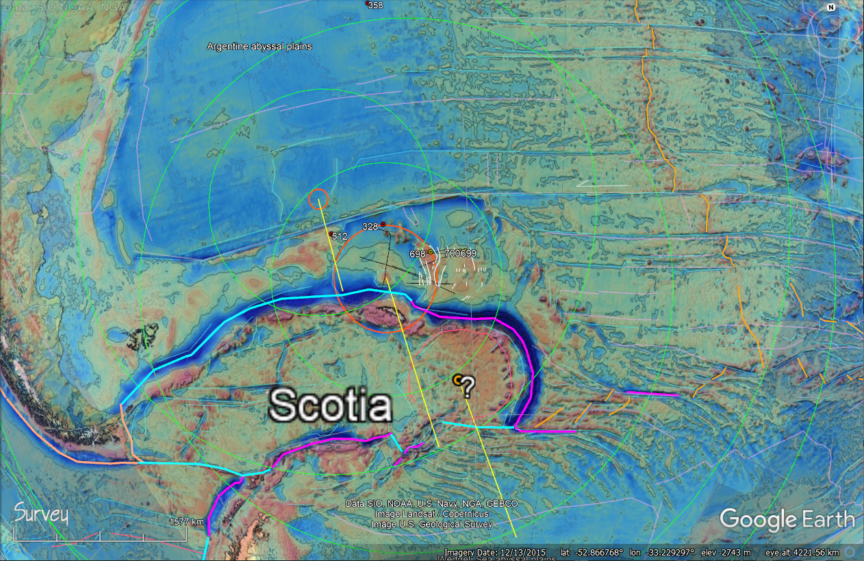 Figure 3. Details of the suspected South Georgia strewn field showing ODP and DSDP seismic-line locations and coreholes. 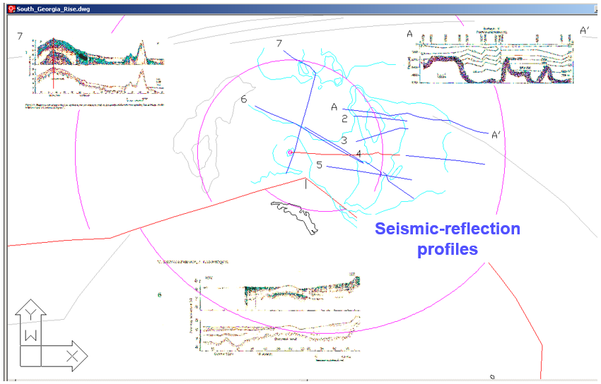 Figure 4. Four ODP seismic-reflection profiles and map locations near South Georgia. The profile depict near-surface basement structure and sediment thickness. 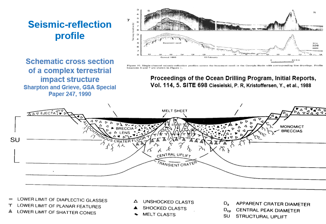 Figure 5. ODP seismic-reflection line 7 profile in comparison to a cross-section representation of a terrestrial impact crater with associated structures. 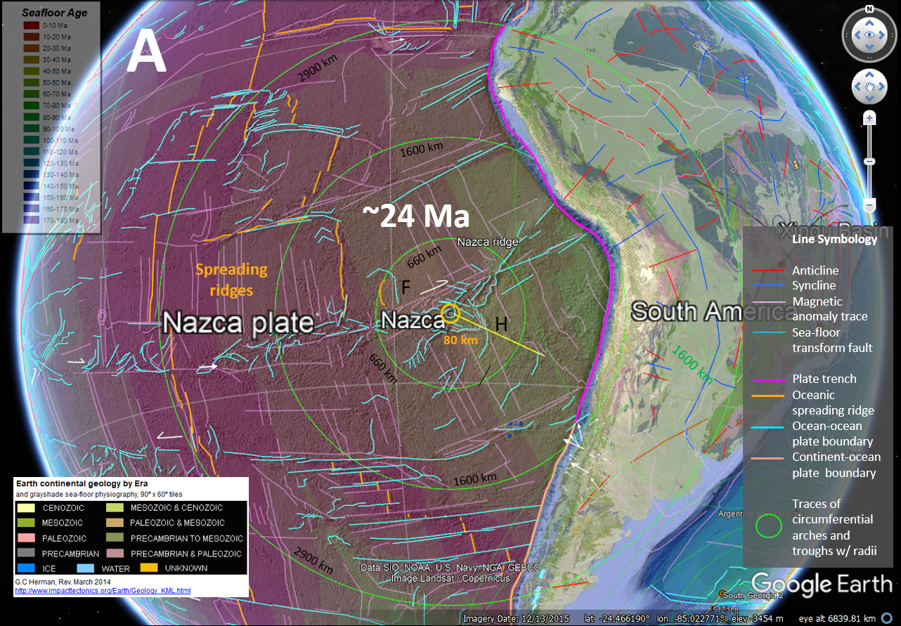 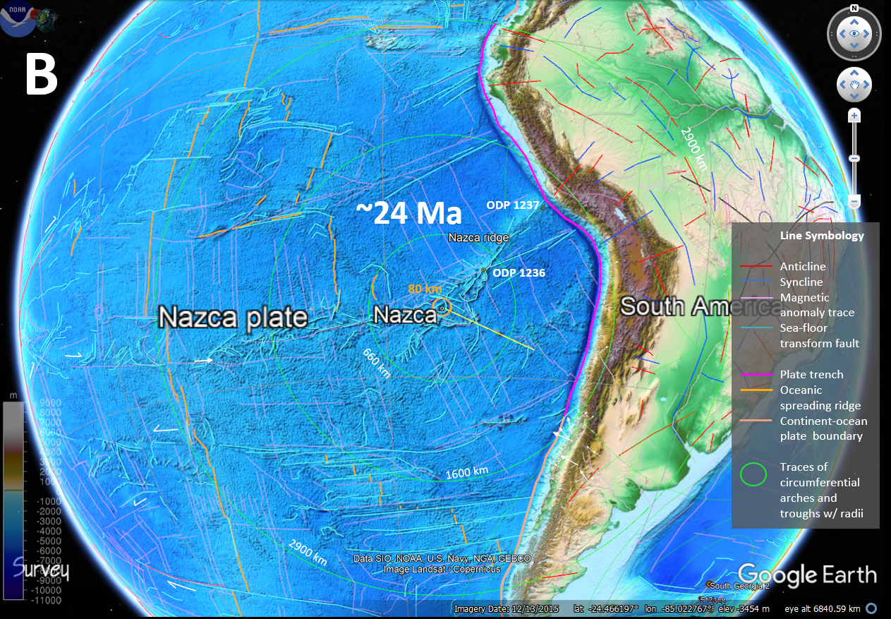 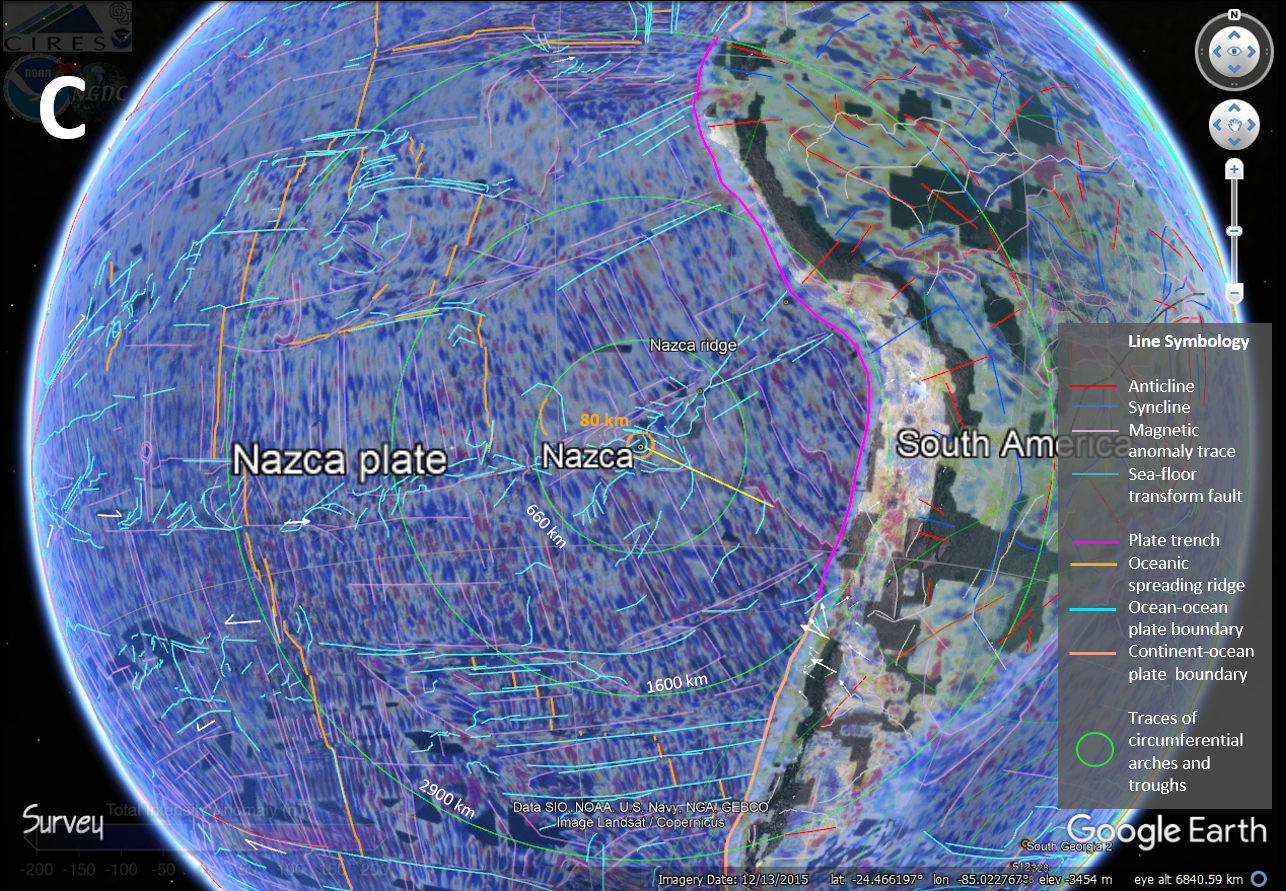  Figure 6. Stacked GE maps showing the suspected Nazca impact crater and surrounding region. Top to bottom global base themes include continental geology by Era and sea-floor age (A), topography (B), and magnetic (C) and gravity (D) anomalies. 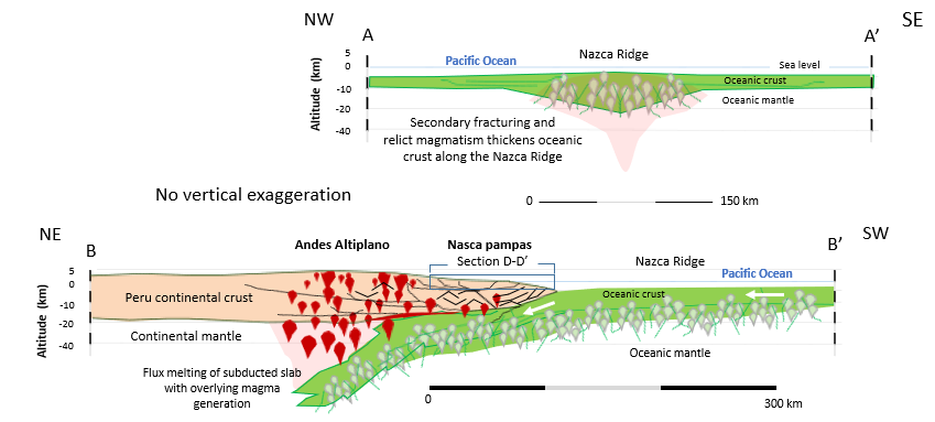 Figure 7. Two cross sections across (A-A') and atop (B-B') the Nazca Ridge showing the abnormally thickened crust being inserted beneath South Amarica. Ocean-Drilling Program Site 1236 Coring results 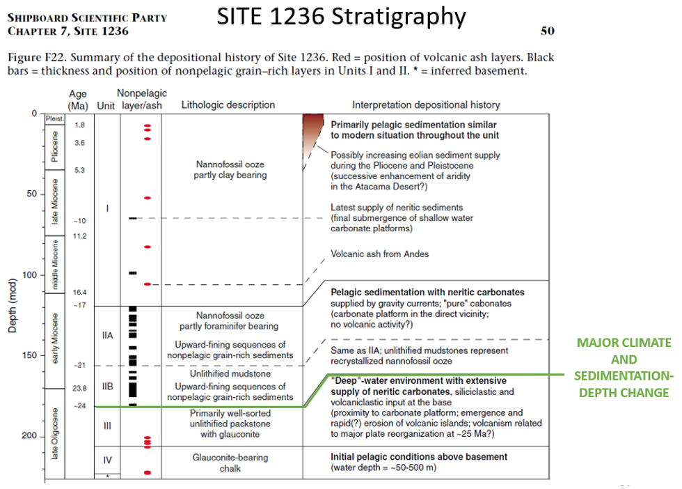 Figure 8. Major climatic and sedimentation changes occur in the stratigraphic record of the Nazca Ridge at ~24 Ma, the suspected age of the Nazca impact crater. 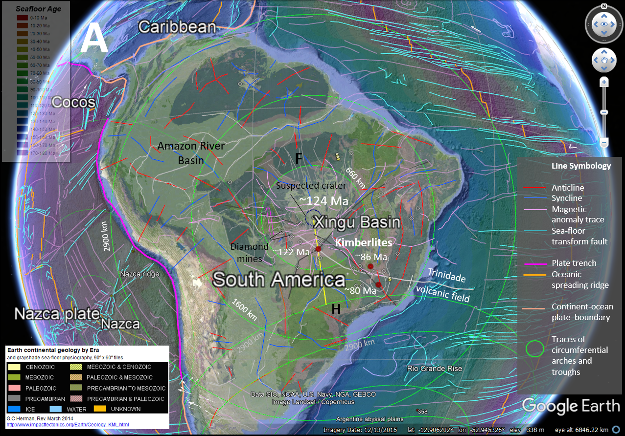 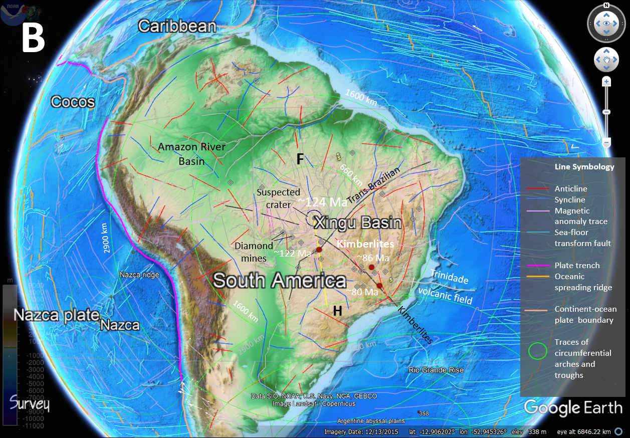 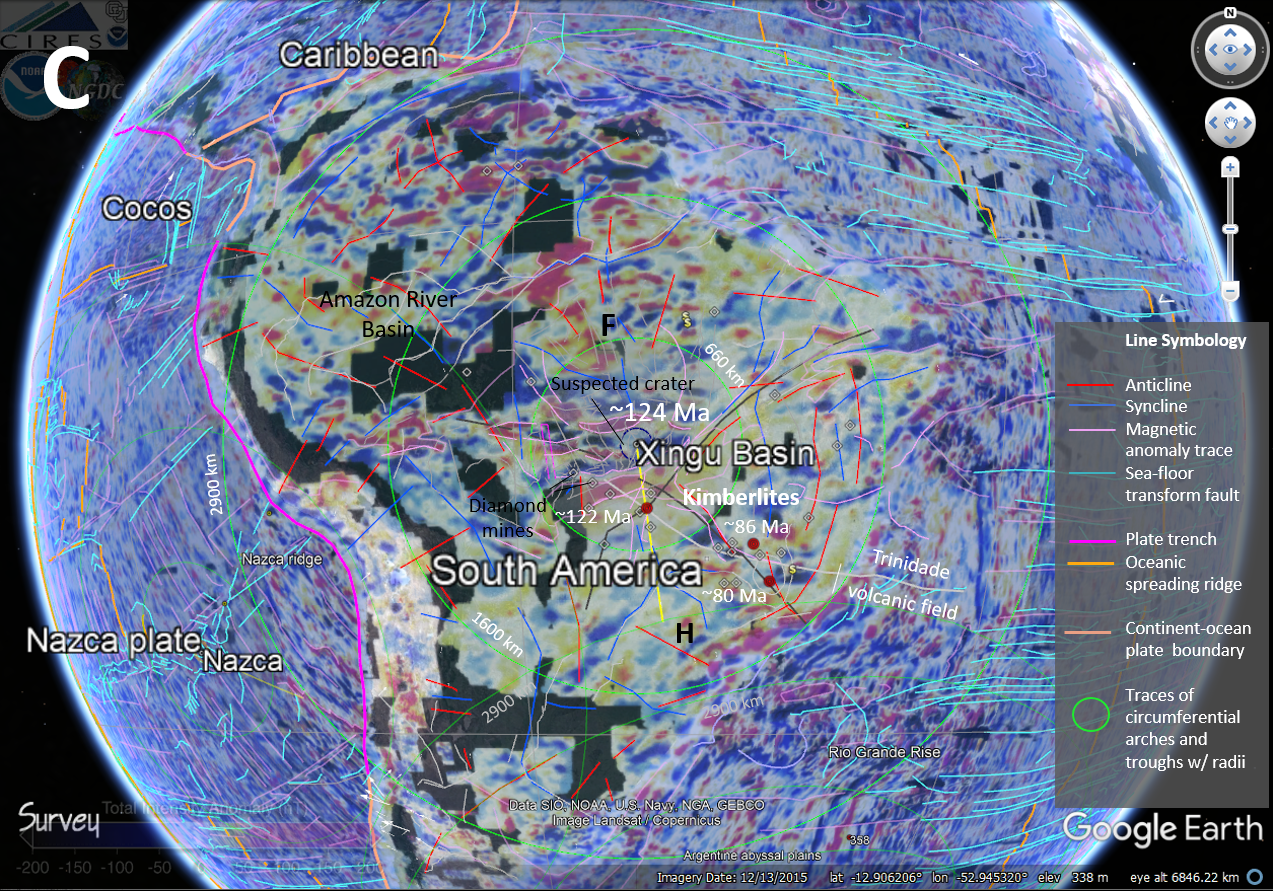 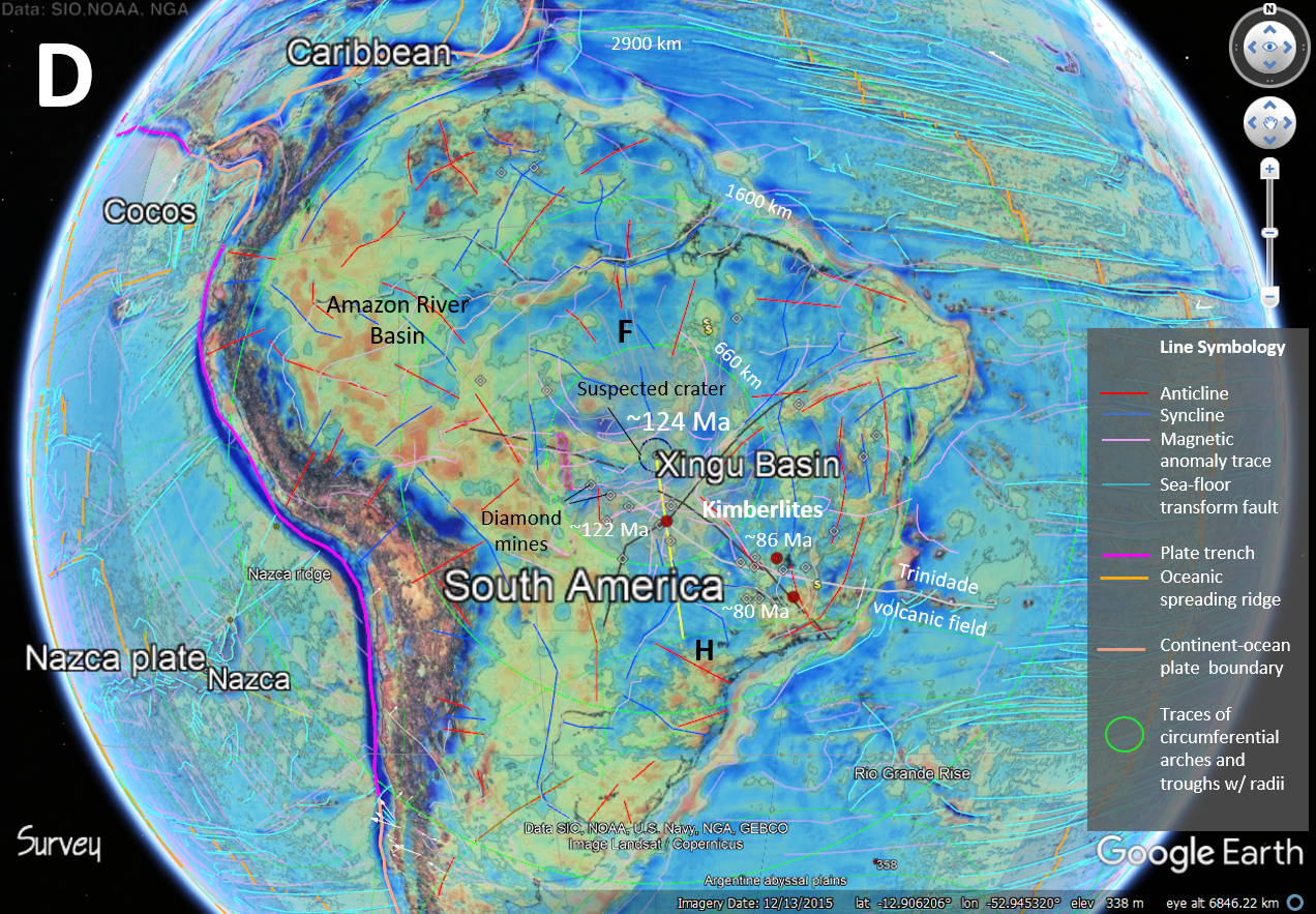 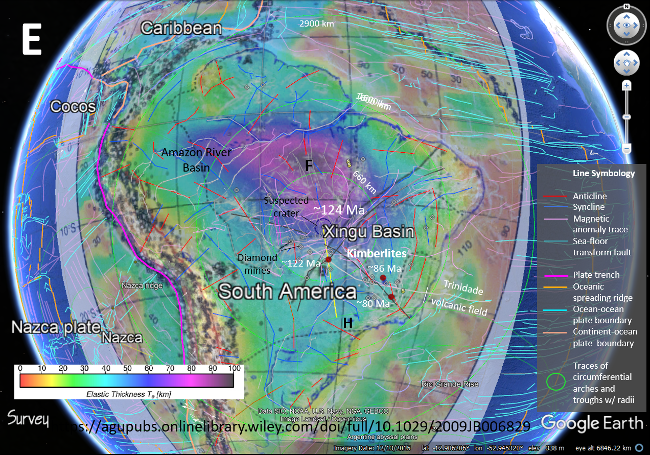 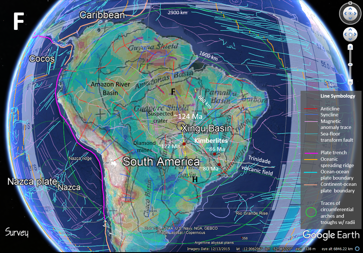 Figure 9. The suspected Xingu Basin impact. |
Gregory Charles Herman, PhD Flemington, New Jersey, USA
Three, suspected, large-bolide impacts in the South American region with estimated ages of 16 Ma, 24 Ma, and 124 Ma.
I herein note the likelihood of the South American region having been struck by km-scale bolides (asteroids or comets with kilometer-scale diameters) at least three times in the past ~124 Ma, primarily based on Earth's physiography, remote-geological mapping using Google Earth (GE; fig. 1), and published literature. Because of the speculative nature of these impact sites they're suspected events and await further scrutiny for validation. The two younger cosmic events probably happened during the Cenozoic Era and impacted the southern Atlantic (figs. 2 to 5) and Pacific (figs. 6 to 8) ocean basins respectfully, whereas the other was a continental impact event that contributed to the formation of the Amazon basin (fig. 1) . Although separated in time, they display structural kinship by having overlapping, far-reaching strain fields that help define the physical expression of both continental and adjacent oceanic realms. Their respective locations, one by land and two by sea, offer a unique opportunity to compare and contrast the resulting strain fields originating in thick continental crust versus thinner oceanic crust, and from having different impact trajectories (table 1).
| Table 1. Suspected impact crater sizes, locations, and trajectories | |||||
| Crater Name | Latitude (Decimal degrees) |
Longitude (Decimal degrees) |
Diameter (km est.) |
Azimuth heading (deg.) |
Incidence angle1 (deg.) |
| South Georgia 1 | -52.615485 | -37.105381 | 300 | 355 | Low |
| South Georgia 2 | -48.022798 | -41.466365 | 100 | 355 | Low |
| South Georgia 3 | -57.918989 | -31.022301 | 300 | 355 | Low |
| Nazca | -24.498811 | 84.985558 | 85 | 292 | Low |
| Xingu Basin | -12.930623 | -52.945323 | <200 | 352 | High |
| 1 Incidence angle measured from 0° (parallel) to 90° (normal) with low (1° to 30°), moderate (31° to 60°), and high (61° to 89°) ranges. | |||||
Each impact astrobleme is mapped with respect to the suspected crater locations using five, geospatial-base themes built for Google Earth (GE) including: 1) Earth continental geology colored by Era (CGBE), 2) Sea-floor age, 3) Global physiography, 4) Global magnetic anomalies, and 5) Global gravity anomalies. The first two of these are used together as a global base covering complimentary oceanic and continental realms. Although assembled by country and made available publicly, the geology by Era base theme was generated using various US Geologic Survey themes originating from their world assessment of petroleum. They are produced by region and were not formerly integrated to the common geologic Eras, so I downloaded and began editing them in 2014 into a unified geospatial theme to share publicly as a GE KMZ file comprised of twelve seamless tiles of raster imagery. This theme is important because it shows many continental, semi-circular or circular, very large sedimentary basins covered by young detritus, and shows where the crustal roots of Proterozoic age (gray) are arched upward to the surface. Other Era designations include those for Paleozoic (pink) and Mesozoic (green) rocks, and younger Cenozoic (yellow) cover. Additional, custom imagery was added to the GE folders for each impact location that aided in their interpretation based on their geological and remotely sensed geophysical expressions. Two complimentary themes are combined with the CGBE theme that cover the oceanic realm. These include a US Geological Survey raster image of Earth physiography that is formatted in geographic space. This is used to show a gray-shaded, ocean- and sea-floor physiography upon which the chronological age of the ocean floor is overlain in semi-transparent mode (fig. 1A for example).
There are probably more large-impact sites in the region not identified here, but these three locations have suspected craters and overlapping, far-reaching, radial strain fields that inexorably link together tectonic aspects of the continent with adjacent parts of Atlantic and Pacific Ocean basins. These three, catastrophic, tectonic agents show spatial and temporal links to some notable geological features and stratigraphic anomalies that help constrain their ages of occurrence. Such features include the East-Pacific magmatic swell and oceanic rise, transcontinental structural lineaments spanning Brazil, and the Trinidade hot-spot track besides the general structural and stratigraphic expression of the region (fig. 1). Another aspect of these astroblemes was mentioned and illustrated in a recent, prior blog entry that included a depiction of how Earth's geomagnetic field may also be influenced by these impacts, which is discussed again below. Each of these suspected events is covered individually below in a temporal sense from the youngest to oldest but each will require closer scrutiny and ground truthing to confirm or disprove their existence.
The South Georgia impact, Southwest Atlantic Ocean (~16 Ma)
Sea-floor physiography in the southwestern Atlantic Ocean includes two, large circular features around the South Georgia islands that look like impact craters in remote imagery like that in the standard Google Earth (GE) virtual globe (figs. 1 and 2). I attempted to add these features to the Earth Impact Database, but their candidacy was rejected in 2013 with no explanation as to why. It's ironic to think that if these features occurred on Mars are Mercury they would have names and be easily counted among the impact crater database for that planet.
The area was geologically assessed during the Ocean-drilling program (ODP) and the Deep-sea drilling project (DSDP) with the results supporting the proposed impact structures (figs 3 to 5.) In addition to the South Georgia 1 (SG1) structure having a raised outer rim of ~300 km diameter (fig. 2), it also has a pronounced, central uplift that together constitute an impact crater on Earth's surface that is visible from space. The other two craters are not as conspicuous, with South Georgia 2 lying just northward of SG1 and another, circular structure at the east end of the Scotia Plate and lying immediately behind SG1 to the south (figs. 2D and 3). SG2 has a triangular shape than fans out to the north, and may be a low-angle ricochet of spalled piece of the SG1 bolide. Continuing northward from SG2, the Argentine Abyss is coated with a blanket of relatively undisturbed pelagic mud (figs 2 and 3) that masks the bedrock physiography. To the south of SG1, a third suspected crater may lie beneath recent basalt flows originating from the volcanic arc of the South Sandwich Islands to the east (fig. 3). This one is highly speculative, but two other, feint, circular, gravitational anomalies lying immediately to the west of SG1 in the Scotia Plate, that are most apparent in the gravity theme (figs. 2B and 3), make me suspect that that the impact event probably involved multiple projectiles that together segmented the former tectonic plate(s) into a new arrangement. The composite set of features would constitute a massive strewn field that probably separated the South American and Antarctic tectonic plates. This event resulted in a tremendous of disruption of Earth's ground and atmospheric systems. With respect to the ground disruption, the three structures portrayed here overstep one another from the the south to north, resulting from an oblique impact along a heading of about 350o, with multiple craters overstepping one another from the south to north (fig. 2).
The scotia Plate is unusual insofar as it is bounded by massive, oceanic transform fault systems of opposite vergence (sinistral to the north and dextral to the south) and involves plutonism, volcanism, and even subduction on the eastern end. The elongate, extensive networks of bounding faults and ensuing ocean-floor structures resemble impact scars stemming from low-trajectory impacts that may include smaller craters stemming from spalled or fragmented pieces of a larger bolide that had the top sheared off of was busted up by the atmospheric entry of at impact. The east-west stretch of the Scotia Plate is proposed to stem from this impact event, but it may have been overprinted by other-aged impact, as tectonic inheritance and/or regional overprinting by other remote tectonic agents is not only possible, but likely.
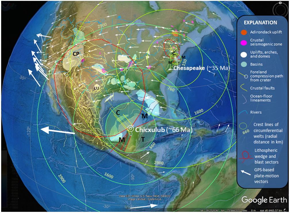
With respect to the climatic disruption, the South Georgia event appears to have occurred in the Middle Miocene during the Langhian (13.65–15.97 mya) stage when there was a sudden warming trend in Antarctica (~15.7 mya ), changes in Atlantic and Pacific ocean circulation, and extinction waves of terrestrial and aquatic life forms (~14.8 to 14.5 mya). The distribution of tektites in the North American tektite strewn field also shows a remarkable spatial coincidence with the proposed foreland trajectory of the South Georgia impacts even though it is currently thought to stem from the Chesapeake impact of Eocene age (~35 Ma).
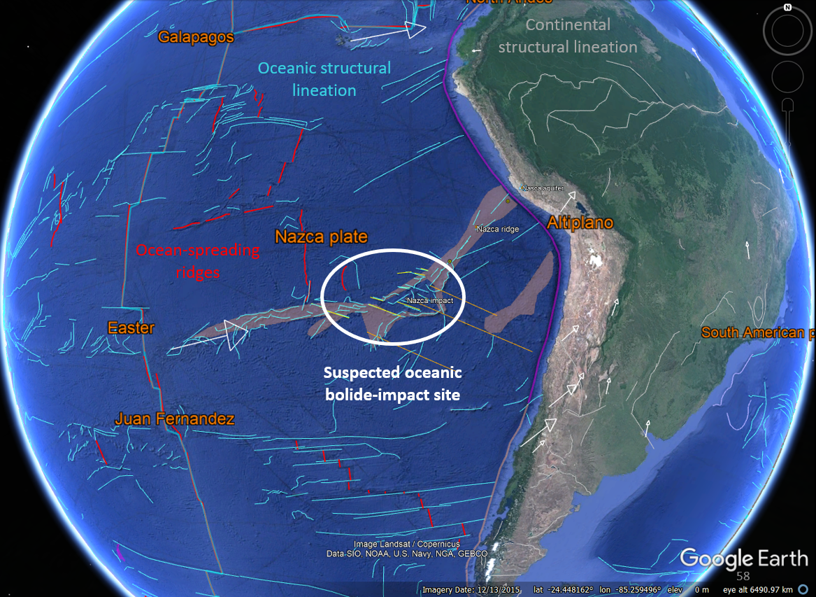
The Nazca impact, Southeast Pacific Ocean (~ 24 Ma)
The suspected Nazca impact event was discovered from using GE to examine the regional tectonic setting of the Nasca Lines. This event appears to have been a shower of bolides or a fragmented, larger one of uncertain composition because of the many circular depressions lying amid a set of linear, ocean-floor fractures aligned along a 390o heading (fig. 5). This set of fractures compliments others where secondary magmatism has risen and thickened the oceanic crust in a region covering almost one-half million square kilometers relative to undisturbed, or 'normal' oceanic crust (fig. 6). The main crater lying at the center of this strain field is about 85 km in diameter (table 1 and fig. 6). The bolide heading is assumed to parallel the 390o fracture set that shows symmetric alignment with ocean-spreading ridges, aseismic ridges, and other structural lineation mapped on the sea floor (fig. 6).
The impact-induced fractures fan out in marginal strain sectors
that likely
indicates a low incidence angle below 45o based on
impact-strain
field experiments.
The Xingu Basin impact, Brazil
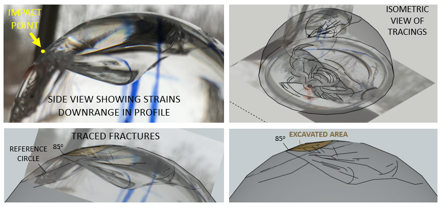
The Xingu Basin impact crater in Brazil is speculative insofar as its blanketed by Cenozoic detritus much like the Chicxulub and Chesapeake impacts on the North American Plate (NAP). This region is currently at the forefront of deforestation and focused, environmental protection measures to address civil encroachment into a relatively virgin forest that is home to many indigenous human tribes. The likelihood of having a buried, large crater in the location is high owing to the preponderance of geological and geophysical data pointing to it. The crater would have a diameter of less than 200 km and situated beneath the Xingu River headwaters in Brazil, resting on the southeast margin of the Amazon shield (figs. 1 and 9). The associated astrobleme, or far-reaching strain field around the crater, includes a circumferential basement arch reaching over 1000-km radius where deeply rooted Proterozoic basement is arched up around it (fig. 1). Continent-wide seismic-wave velocity and satellite analyses reveals an anomalously thick wedge of continental crust that flares out northward from the proposed crater location. Together, these data point to the probability of this wedge as a contracted and faulted crustal lying downrange in front of an large, buried crater formed from a hypervelocity bolide impact of a high- to moderate-angle incidence angle directed toward azimuth ~350o (table 1). The resulting outward-fanning triangle of compacted and thickened bedrock stems from suddenly imposed compression. Foreland-crustal models of this type of phenomenon are seen for the Chicxulub and Chesapeake impacts on the North American Plate where impact effects are seen spanning the continental United States. A scaled-down experimental model of such foreland strains was achieved in a set of impact-experiments using 60mm-diameter glass balls. For the Xingu impact, compressional tectonic structures fan outward to the North where the crust was punched and depressed close to the crater, but uplifted at remote distances reaching at least 2900 km distance from the crater from the dissipation of refracted, impact-induced seismic energy.
The age of this suspected event is uncertain, with the most compelling chronological data being a nearby diamondiferous, kimberlitic intrusion having a radiometric age of about ~122 Ma, the oldest, apparent age of volcanism in the Trinidade hot spot track beginning there and leading progressively eastward to active volcanism in the Trinidade archipelago. This hot-spot trace lies almost directly behind the proposed crater location (fig. 2) in the extended, hinterland strain sector where impact-induced, decompression melting in the mantle is expected to occur with ensuing plutonism or volcanism. The timing behind impact and magma generation is therefore poorly constrained and may be on the order of many million of years (Ma) from that proposed (table 1). This event appears to have catastrophically altered the craton structure, and as such is an integral aspect of Amazon River Basin structural evolution. The Amazon River Basin follows a great crustal synclinorium developed along faults and fracture systems spanning the width of South America linking transform faults in the flanking ocean basins.
Two major, deeply-penetrating fracture and fault systems mapped on the South American continent include the Trans Brazilian and Kimberlitic lineaments depicted in figure 9 and labeled in figure 9B. These structures may be partially inherited secondary structures cutting the lithosphere and crust. Their geospatial alignment and geometry are conformable with this event as they define the foreland, lateral, and hinterland blast sectors, with the preponderance of magmatic activity stemming from impact focused in the lateral and hind ward sectors relative to the suspected descent trajectory of the bolide (figs, 1 and 9). Large crustal lineaments crisscross in the wake of the suspected crater, both of which are recognized and named the Trans Brazilian and Trinidade lineaments (9D). The correspondence of kimberlite and other plutonism and volcanism along these structures is
A fifth (fig. 7E) and sixth (fig. 7F) map of the Xingu impact event are presented that show the results of continental-wide, seismological sensing of the continental crust with respect to it's elastic thickness (ref.) and depth to the Moho (ref.), respectively. These journeyed results lend further credence to this suspected cratering event reasonable for the thickened wedge of terra firma defining the southern limits of the Amazon basin that extends north and foreland sector where the depressed and compacted crust and lithosphere have been pushed, faulted, and thickened immediately downrange from the oblique strike.
Discussion
All three impact events appear to have trajectory headings from the south towards the north in the Earth geographic reference frame (table 1). The two oceanic impact events likely originated from low-angle strikes in the 30o to 45o range whereas the Xingu Basin, continental event was likely of higher incidence, greater than 45o, based solely on the geometry of the resulting astroblemes. Bench-top impact experiments using glass balls show that low-angle impacts have the majority of resulting fractures and faults radiating laterally outward relative to the crater and trajectory heading, but for high-incident events they are more focused in the foreland sector. Obliquely incident impacts generally focus the bolides linear momentum down range along it's heading.
Large-bolides with high to moderate traction can collide at hypevelocities reaching 70 km/sec. Collisions with Earth at these speeds immediately transfer tremendous amounts of linear momentum that instantaneously ruptures and compresses the lithosphere downrange. Upon impact, large, deep fault systems propagate away from the crater an order of magnitude faster than primary p- and s- seismic body waves can be transmitted (~4 to 9 km/sec). These are far-field, brittle, grounded strains reaching well beyond the crater that dissipate into absorbed ground energy from elastodynamic rupture and the generation of distributed, secondary, remote seismic disturbances. The fractional amount of grounded impact energy dispersed outside of the crater is referred to as Eseismic that is dispersed and absorbed through frictional heating and brittle failure deep into the mantle and new igneous melts are instantly produced in tensional strain regimes. Impact generated heat agents also drive resulting hydrothermal responses, including vein mineralization at remote distances like that seen for the Chesapeake impact (Mathur and others, 2015). Uncertainties yet exist through regarding the nature of the post-impact ductile Earth response to lithospheric rupturing and flexure. But at this time, it seems that most of the impact-generated welting and igneous activity occurs within a five-million year span from impact, with even longer consequences to geodynamic motions seen in an evolving system reflective of punctuated equilibrium.
The manner in which Earth materials absorb bolide-impact energy (Ekinetic) conforms to the laws of thermodynamics and continuum mechanics. Most bolide-impact experiments that address (Eseismic) focus on the nature of the primary p-wave reflection generated by collision, and fail to consider other seismogenic, elastodynamic responses in the crust and lithosphere. A large impact generates strain effects that include epeirogeny, and deep, brittle rupturing from the immediate transfer of linear momentum and absorption of impact energy at very high strain rates. Conservatively low estimates of the seismic efficiency factor (k; Eseismic/Ebolide kinetic) ranging from ~ 10-6 to 10-3 are used to model the primary, hemispherical wave fronts emanating from the seismic source that converge at the spherical antipode (refs). Such k values are gained from laboratory and missile-range projectile-and-target tests, and studies of project-module collisions on lunar and Martian surfaces (refs). But early, experimentally derived estimates of k derived from impact experiments into compact basalt reached 10-2 (Gault and Heitowit, 1963). The aforementioned values stem from cm- or m-scale impact tests and models fail to reflect the physical conditions that govern large impact events on lunar and planetary surfaces. Schultz and Gault (1975) also point out that k values would increase with deeper penetration of the projectile into the target. All agree that k is a loosely constrained parameter for km-scale impact events that have not been directly observed historically. Therefore, I propose that k may reach as high as 10% (10-1) or higher for km-scale, mountain-building events. k varies as a function of initial velocities, spins, trajectories and compositions of the colliding bodies. Intuitively, normal-incident events would have more traction and higher k values than low-angle impacts that nearly parallel a bodies surface. This is likely a geometric function like that derived from charting mapped strain-field areas (x) relative to incident angles (y, where x = .0001y2) for the 60mm glass balls.
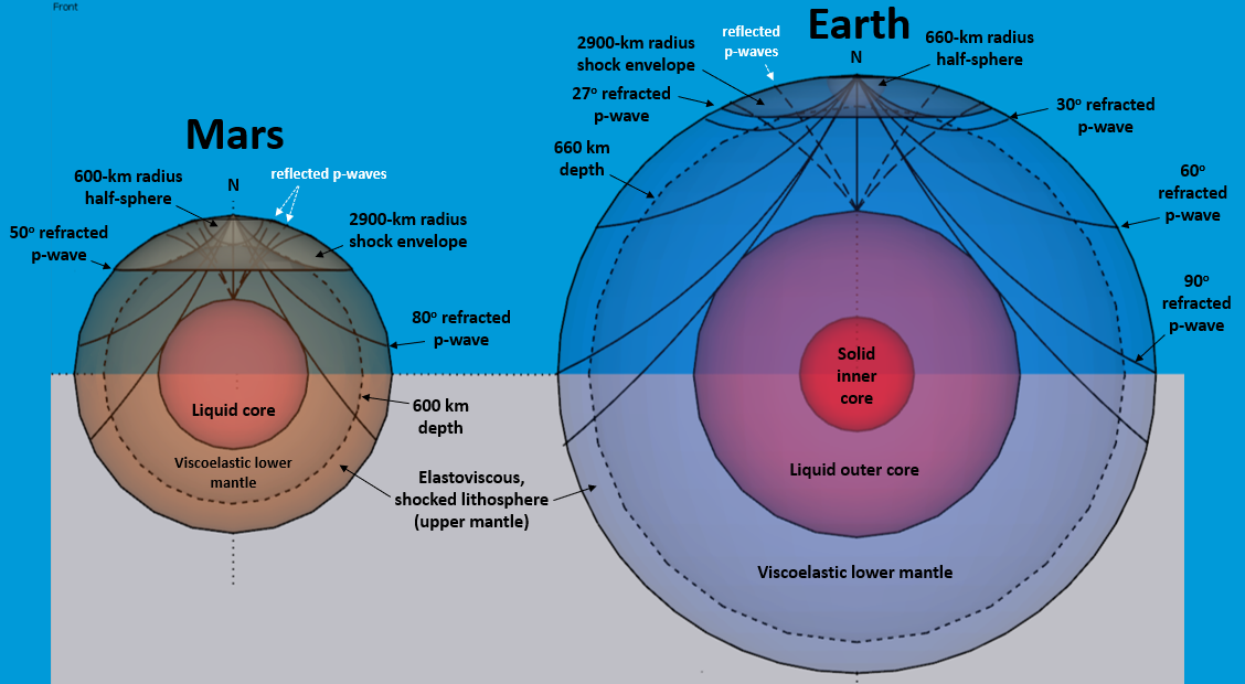
After having recognized the effects of remote, epierogenic and sector-based strain partitioning as part of an impact astrobleme, it is also important to consider how overlapping strain fields will interfere with one another. Overlapping epeirogenic welts can have pronounced, regional uplifts or subsidence from epeirogenic interference. These impact-generated seismogenic welts are represented using 660, 1600, and 2900-km surface rings generated around each crater's center point by using a custom ring-generating program built for GE called Range Rings. The inner, 660-km rings traces the boundary of a strain-hardened half-shell of lithosphere that was shocked by impact, and in the case of the Chicxulub impact, lacking plate-tectonic seismicity and significant lateral drift (Herman, 2005). Beyond the inner shell, a 1600-km ring may coincide with outboard seismogenic zones and elevated areas coinciding with continental margins, like that seen for the Nazca (fig. 7) and Xingu Basin events (fig. 9). The largest, 2900-km ring is of utmost importance as it may define the strain limits of the astrobleme where a pronounced arch appears to be centered that likely stems from primary, refracted p- and s-waves s that suddenly return an incredible amount of ground energy back to Earth's surface at that distance from the crater owing to the planets rheology. In the case of the Chicxulub event, this distance coincides with an abrupt increase in plate drift for the NAP, and trace regional, epierogenic movements like the Laramide orogeny in the US Rocky Mountains. The 2900-km arches mapped for these three events, all parallel notable surface features including, the East-Pacific rise (Nazca), segments of the mid-Atlantic Ridge (Xingu), and continental anticlinoriums in South America (South Georgia 1). As one might anticipate, areas having km-scale arches that overlap correspond to areas having deep basement is raised and eroded, while those having overlapped, subsided aeas will correspond with deep sedimentary basins. And depending upon the intensity of each event, overlapped arches and throughs may show comparatively muted epeirogenesis but corresponding unconformities and overlaps. Such is the case for the Chicxulub and Chesapeake astroblemes on the North American plate (NAP; Herman, 2006). When considering the incredible surface spans that these astroblemes cover, any large impact event occurring in the same spherical quadrant will overprint younger ones touching upon the same quadrant. There are likely instances where entire, regional-scale fault systems become bent and deflected from there original paths because of remote, unrelated, impact tectogenesis. This is likely the case for the Scotia Plate, because the 2900-km radii arch from another suspected bolide impact in Antarctica perfectly circumscribes the curved oceanic transform faults immediately south of SG3 that otherwise appear to be dragged by fault slip along the southern Scotia-plate boundary. Failure to account for epeirogenic strains in plate-tectonic reconstructions will cause model inconsistences that could otherwise benefit from incorporating such strain effects. There is no doubt that large, quasi-periodic, catastrophic impacts events contribute to the structural evolution of our planet's surface.
According to Shoemakers and others (1990), craters multiple, large craters such as SG1 and SG2 that are part of the Scotia plate shouldn't exist. That is, a crater with a diameter of 300 km is predicted to occur only once in past 100,000 years from a comet impact by Shoemaker and others (1990). Either this is the one, or there are more. For comparison, the official crater diameters for the Chicxulub and Chesapeake impacts according to the on-line Earth Impact Database are 'only' 170 km and 90 km respectively. Shoemaker and others (1990) also predict a total of 109 large-bolide Earth impacts over the past 100 Ma that would produce craters larger than 30-km diameter, yet only 25 known and confirmed craters of this save have been mapped on Earth so far, or less than 25%.
The physical
effects that these three, large, suspected impacts have on Earth's geomagnetic
dynamo were previously shown and discussed in my
2021 Geomagnetic Reversal
Tectonics-blog entry.
References
de Moraes Rocha, L. G., Correa, R. T., da Silva, A. B., and Matos, D. R., 2019, Geophysical reassessment of the Azimuth 125° Lineament: emplacement model and propagation of its dikes: Journal of the Geological Survey of Brazil, vol. 2, no 1, p. 87-98
![]() Impacttectonics.org *
G.C. Herman
Impacttectonics.org *
G.C. Herman

